Category:Kimotsuki, Kagoshima
Zur Navigation springen
Zur Suche springen
English: Kimotsuki is a Town in Kagoshima prefecture, Japan. It is famous for Uchinoura Space Center, Yabusame.
| Cities | Kagoshima · Kanoya · Makurazaki · Akune · Izumi · Ibusuki · Nishinoomote · Tarumizu · Satsumasendai · Hioki · Soo · Kirishima · Ichikikushikino · Minamisatsuma · Shibushi · Amami · Minamikyushu · Isa · Aira |
|---|---|
| Towns | Satsuma · Nagashima · Yusui · Osaki · Higashikushira · Kinko · Minamiosumi · kimotsuki · Nakatane · Minamitane · Yakushima · Setouchi · Tatsugo · Kikai · Tokunoshima · Amagi · Isen · Wadomari · China · Yoron |
| Villages | |

Ort in der Präfektur Kagoshima, Japan | |||||
| Medium hochladen | |||||
| Ist ein(e) | |||||
|---|---|---|---|---|---|
| Ort |
| ||||
| Liegt am oder im Gewässer | |||||
| Rechtsform |
| ||||
| Datum der Gründung, Erstellung, Entstehung, Erbauung |
| ||||
| Einwohnerzahl |
| ||||
| Fläche |
| ||||
| Ersetzt |
| ||||
| offizielle Website | |||||
 | |||||
Unterkategorien
Es werden 10 von insgesamt 10 Unterkategorien in dieser Kategorie angezeigt:
In Klammern die Anzahl der enthaltenen Kategorien (K), Seiten (S), Dateien (D)
N
- Nikaido Family Residence (4 D)
O
- Ōsumi-Kōyama Station (4 D)
S
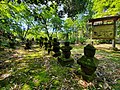
- Shijukusho-jinja (4 D)
T
- Takada Falls (7 D)
- Tsukazaki no Kusu (4 D)
U
- Uchinoura Bay (Kagoshima) (3 D)
Medien in der Kategorie „Kimotsuki, Kagoshima“
Folgende 81 Dateien sind in dieser Kategorie, von 81 insgesamt.
-
 Emblem of Kimotsuki, Kagoshima.svg 538 × 540; 2 KB
-
 Flag of Kimotsuki, Kagoshima.svg 900 × 600; 2 KB
-
 (Other), Kimotsuki, Kimotsuki District, Kagoshima Prefecture 893-1200, Japan - panoramio.jpg 4.592 × 3.448; 9,19 MB
-
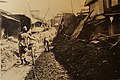
 1938 Kimotsuki District Storm and Flood Damages Koyama Cultivated land near Maeda-bashi.jpg 3.500 × 2.625; 5,27 MB
-
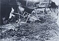
 1938 Kimotsuki District Storm and Flood Damages Koyama Maeda North.jpg 3.500 × 2.625; 4,88 MB
-
 1938 Kimotsuki District Storm and Flood Damages Koyama Sakai-River Embankment.jpg 3.500 × 2.625; 5,21 MB
-
 1938 Kimotsuki District Storm and Flood Damages Koyama Shinmachi Dori 02.jpg 3.500 × 2.333; 5,13 MB
-
 1938 Kimotsuki District Storm and Flood Damages Koyama Shinmachi Dori.jpg 3.500 × 2.333; 3,85 MB
-
 1938 Kimotsuki District Storm and Flood Damages Koyama Shopping Street (Nomachi).jpg 2.372 × 1.648; 2,08 MB
-
 1938 Kimotsuki District Storm and Flood Damages Koyama Sinsei-dori.jpg 3.500 × 2.333; 5,65 MB
-
 1938 Kimotsuki District Storm and Flood Damages Uchinoura Coast wood washed ashore.jpg 3.500 × 2.333; 5,21 MB
-

-
 Doryu-ji Koyama 2015 01.JPG 1.632 × 1.224; 1,3 MB
-
 Doryu-ji Koyama 2015 02.JPG 1.632 × 1.224; 905 KB
-
 Doryu-ji Koyama 202009 01.jpg 4.608 × 3.456; 8,93 MB
-
 Doyadoyasaa 2014 01.JPG 2.073 × 1.555; 1,03 MB
-
 Emblem of Kimotsuki, Kagoshima.jpg 290 × 250; 19 KB
-
 Emblem of Kōyama, Kagoshima (1972–2005).gif 72 × 68; 2 KB
-
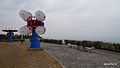
 Epsilon Rocket Monument Kimotsuki.JPG 1.541 × 2.072; 827 KB
-
 Flag of Kimotuki Kagoshima.JPG 524 × 324; 21 KB
-
 Flag of Kōyama, Kagoshima (1972–2005).png 170 × 101; 6 KB
-
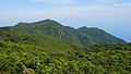
 Gongenyama Mt Kimotsuki Kagoshima.jpg 3.328 × 1.872; 2,9 MB
-
 Granite of Kishira Beach.jpg 3.648 × 2.736; 1,83 MB
-
 Hayabusa in Kimotsuki Tomiyama.JPG 1.459 × 1.094; 577 KB
-
 Hoyoshidake Kagoshima.jpg 2.942 × 2.206; 578 KB
-
 Inaodake from Shizenishi.JPG 1.920 × 1.080; 1,04 MB
-
 JA Kagoshima-Kimotsuki Uchinoura Branch 2014.JPG 1.684 × 1.263; 551 KB
-
 Kagoshima Pref road 542 Kimotsuki Oryuno.JPG 1.497 × 1.996; 1.009 KB
-
 Kagoshima Pref Road 554 Kimotsuki Miyage 01.jpg 1.280 × 720; 264 KB
-
 Kagoshima Pref Road 68 Kimotsuki Kasanohara.JPG 2.121 × 1.591; 996 KB
-
 Kagoshima Pref Road 73 Kimotsuki Niitomi 01.jpg 1.814 × 1.089; 727 KB
-
 Kasano Yakushi 2009.jpg 1.280 × 720; 671 KB
-
 Kimotsuki in Kagoshima Prefecture Ja.svg 395 × 777; 12 KB
-
 Kimotsuki in Kagoshima Prefecture.png 1.201 × 801; 34 KB
-
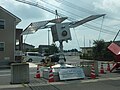
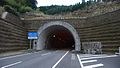 Kimotsuki Kunimi Tunnel Koyama side.jpg 1.440 × 810; 543 KB
-
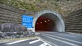 Kimotsuki Kunimi Tunnel Uchinoura side.jpg 1.440 × 810; 592 KB
-
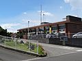 Kimotsuki Police Station 2013.JPG 1.684 × 1.263; 781 KB
-
 Kimotsuki River Kimotsuki Hami 01.JPG 1.684 × 1.263; 858 KB
-
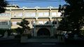
 Kimotsuki Town Museum.JPG 1.651 × 916; 526 KB
-
 Kimotsuki Town Office Kagoshima 200809.jpg 1.920 × 1.080; 627 KB
-
 Kimotsuki Town Office Kishira Branch.JPG 1.684 × 1.263; 948 KB
-
 Kimotsuki Town Office Uchinoura Synthesis Branch.jpg 1.536 × 1.152; 491 KB
-
 Kimotsuki Town Working Youth Home 2022.jpg 4.032 × 3.024; 4,85 MB
-
 Kishira Coast 2010.JPG 1.920 × 1.080; 678 KB
-
 Kouyamajou Kagoshima Japan.jpg 3.328 × 1.872; 2,58 MB
-
 Koyama Onsen Dome 2008.jpg 1.440 × 810; 497 KB
-
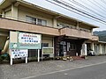
 Koyama Post Office Kagoshima 2014.JPG 1.594 × 1.183; 642 KB
-
 Koyama River Flood Histrical Monument.jpg 4.032 × 3.024; 4,9 MB
-
 Koyama River Kagoshima.JPG 1.280 × 720; 364 KB
-
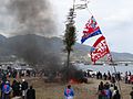
 Koyama Yabusame 2011.JPG 1.352 × 1.809; 979 KB
-
 MLIT Osumi Office of River and National Highway.JPG 1.684 × 1.263; 684 KB
-
 NDL-DC 762376 0331 0018crd-NamimiUra.jpg 559 × 383; 32 KB
-
 Niitomi Kimotsuki Kagoshima 01.JPG 1.920 × 1.080; 651 KB
-
 Osumi Soroban 1949 1029.jpg 2.780 × 1.762; 1,85 MB
-
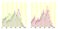 Population distribution of Kimotsuki, Kagoshima, Japan.svg 512 × 256; 22 KB
-
 Ronji Meeting Place Kimotsuki.jpg 4.032 × 3.024; 4,91 MB
-
 Route448 Dai2Ariakebashi.jpg 1.920 × 1.080; 609 KB
-
 Route448 ja Uchinoura Jupiter Bridge 2016.JPG 2.121 × 1.591; 1,22 MB
-
 Route448 Kishira 01.JPG 1.440 × 810; 460 KB
-
 Route448 Uchinoura 01.jpg 1.781 × 1.336; 833 KB
-
 SunGames Kanoya 2020.jpg 4.447 × 3.335; 2,51 MB
-
 Todoroki Falls Kimotsuki.JPG 1.684 × 1.263; 1,04 MB
-
 きもつき情報化推進センター 2016-06-22.jpg 4.704 × 3.136; 6,84 MB
-
 ロケットの見える丘PA - panoramio.jpg 1.600 × 900; 210 KB
-
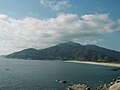
 内之浦 - panoramio.jpg 4.672 × 3.104; 10,85 MB
-
 内之浦町岸良海岸-utinoura - panoramio.jpg 480 × 640; 30 KB
-
 内之浦町船間-utinoura - panoramio.jpg 480 × 640; 50 KB
-
 内之浦2-utinoura - panoramio.jpg 1.600 × 1.200; 399 KB
-
 内之浦3-utinoura - panoramio.jpg 1.600 × 1.200; 426 KB
-
 叶岳ふれあいの森より内之浦市街地-utinoura - panoramio.jpg 1.600 × 1.200; 427 KB
-
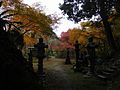
 四十九所神社 - panoramio.jpg 4.672 × 3.104; 10,1 MB
-
 太平洋.JPG 4.608 × 3.440; 3,29 MB
-
 小串トンネル - panoramio.jpg 1.600 × 900; 270 KB
-
 岸良 - panoramio.jpg 4.288 × 2.848; 5,19 MB
-
 岸良展望所からの景色 - panoramio.jpg 4.672 × 3.104; 11,02 MB
-
 岸良~内之浦 - panoramio.jpg 4.288 × 2.848; 5,49 MB
-
 笠之原 - panoramio.jpg 3.264 × 2.448; 2,14 MB
-
 肝付町立有明小学校グランドから見下ろす志布志湾(旧高山町立).JPG 4.608 × 3.440; 2,77 MB
-
 辺塚海岸 - panoramio.jpg 3.648 × 2.736; 4,11 MB
-
 辺塚海岸2 - panoramio.jpg 3.648 × 2.736; 4,97 MB
-
 辺塚海岸① - panoramio.jpg 3.264 × 2.448; 1,33 MB


.jpg)


.JPG)


,_Kimotsuki,_Kimotsuki_District,_Kagoshima_Prefecture_893-1200,_Japan_-_panoramio.jpg)
.gif)
.png)