Category:Kingsand
Aller à la navigation
Aller à la recherche
village britannique  | |||||
| Téléverser des médias | |||||
| Nature de l’élément | |||||
|---|---|---|---|---|---|
| Lieu | Maker-with-Rame, Cornouailles, Angleterre du Sud-Ouest, Angleterre | ||||
 | |||||
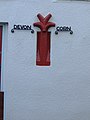
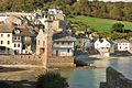
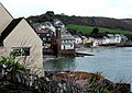
English: Kingsand and Cawsand are twin villages on the Rame Peninsula located in South East Cornwall, United Kingdom, across the sound from Plymouth. Until 1844 Kingsand was in Devon, but Cawsand was always in Cornwall. On the old county boundary between the two villages there is still a house called Devon Corn, which has the marker on the front of the house. The villages are popular with tourists, but so far retain their traditional character - however the population has declined over recent years due to the increased popularity of holiday homes.
Sous-catégories
Cette catégorie comprend seulement la sous-catégorie ci-dessous.
K
- Kingsand Beach (9 F)
Média dans la catégorie « Kingsand »
Cette catégorie comprend 58 fichiers, dont les 58 ci-dessous.
-
 A small geo next to Cavehole Cellars - geograph.org.uk - 3831987.jpg 1 333 × 1 000 ; 1,13 Mio
-
 Aquatic pursuits in Cawsand Bay - geograph.org.uk - 3834694.jpg 1 066 × 1 000 ; 752 kio
-
 Cawsand - Panoramic view eastwards - geograph.org.uk - 741289.jpg 640 × 145 ; 93 kio
-
 Cawsand banner Cawsand from Heybrook Bay.jpg 4 120 × 589 ; 1,11 Mio
-
 Cawsand Bay - geograph.org.uk - 5101738.jpg 640 × 480 ; 39 kio
-
 Cawsand Bay with boats from The Cleave, Kingsand - geograph.org.uk - 6233393.jpg 1 333 × 1 000 ; 1 Mio
-

-
 Cawsand from Heybrook Bay.jpg 4 120 × 2 725 ; 4,38 Mio
-
 Cawsand village UK.jpg 1 600 × 1 200 ; 755 kio
-
 Cawsands Battery - geograph.org.uk - 5605511.jpg 640 × 426 ; 54 kio
-
 Coastline near Sandway Point - geograph.org.uk - 5605488.jpg 640 × 426 ; 70 kio
-
 Devon Corn - geograph.org.uk - 150318.jpg 480 × 640 ; 93 kio
-
 Drakes Island from Kingsand - geograph.org.uk - 3935949.jpg 1 024 × 683 ; 201 kio
-
 Garrett Street - geograph.org.uk - 6262773.jpg 3 648 × 5 472 ; 4,41 Mio
-
 Kingsand - geograph.org.uk - 31426.jpg 640 × 395 ; 95 kio
-
 Kingsand - geograph.org.uk - 5605503.jpg 640 × 426 ; 60 kio
-
 Kingsand and Cawsand - geograph.org.uk - 1271628.jpg 640 × 480 ; 114 kio
-
 Kingsand and cawsand from the sea - geograph.org.uk - 357165.jpg 640 × 425 ; 55 kio
-
 Kingsand and its beach - geograph.org.uk - 1609224.jpg 640 × 480 ; 85 kio
-
 Kingsand Beach - geograph.org.uk - 2924684.jpg 1 234 × 1 000 ; 1,5 Mio
-
 Kingsand Clock Tower - geograph.org.uk - 1537863.jpg 640 × 428 ; 100 kio
-
 Kingsand from Cawsand - geograph.org.uk - 150315.jpg 640 × 453 ; 88 kio
-
 Kingsand from the sea - geograph.org.uk - 6233392.jpg 1 462 × 1 000 ; 1,05 Mio
-
 Kingsand towards Plymouth - geograph.org.uk - 357153.jpg 640 × 480 ; 101 kio
-
 Kingsand, Cornwall - Eventide house.jpg 3 000 × 4 000 ; 3,63 Mio
-
 Kingsand, Cornwall - Halfway House Inn.jpg 4 000 × 3 000 ; 2,17 Mio
-
 Kingsand, Cornwall - The Institute (north facade).jpg 3 000 × 4 000 ; 4,03 Mio
-
 Kingsand, Cornwall - The Institute.jpg 4 000 × 3 000 ; 3,56 Mio
-
 Kingsand, Cornwall, UK.jpg 4 000 × 2 500 ; 6,73 Mio
-
 Kingsand, Torpoint PL10, UK - panoramio (1).jpg 2 048 × 1 150 ; 576 kio
-
 Kingsand, Torpoint PL10, UK - panoramio.jpg 1 600 × 899 ; 308 kio
-
 Low tide at Kingsand - geograph.org.uk - 2374336.jpg 1 024 × 768 ; 335 kio
-
 Maker with Rame Community Hall, former St Paul's Church, Kingsand.jpg 1 500 × 1 113 ; 840 kio
-
 Maker with Rame, Kingsand - geograph.org.uk - 498660.jpg 640 × 427 ; 171 kio
-
 Maker with Rame, Kingsand from Cawsand - geograph.org.uk - 505986.jpg 640 × 427 ; 183 kio
-
 Minadew Brakes near Kingsand (2) - geograph.org.uk - 224359.jpg 640 × 427 ; 69 kio
-
 Minadew Brakes, near Kingsand (1) - geograph.org.uk - 224351.jpg 640 × 427 ; 90 kio
-
 North east of Kingsand - geograph.org.uk - 5605514.jpg 640 × 426 ; 68 kio
-
 Old Pilchard Cellars - geograph.org.uk - 794613.jpg 640 × 427 ; 146 kio
-
 On the Path to Hooe Lake Valley - geograph.org.uk - 104662.jpg 640 × 382 ; 85 kio
-
 Plymouth Sound from Kingsand town - geograph.org.uk - 3935937.jpg 1 024 × 683 ; 221 kio
-
 RNLI Lifeboat in Cawsand Bay - geograph.org.uk - 3831155.jpg 1 112 × 1 000 ; 712 kio
-
 Rocks near Sandway Point - geograph.org.uk - 150251.jpg 640 × 480 ; 95 kio
-
 Signpost at the footpath junction, Kingsand - geograph.org.uk - 224367.jpg 640 × 427 ; 147 kio
-
 The Black Prince Flower Boat Procession - geograph.org.uk - 789483.jpg 640 × 384 ; 128 kio
-
 The Cleave, Kingsand - geograph.org.uk - 150321.jpg 640 × 480 ; 123 kio
-
 The Cleave, Kingsand - geograph.org.uk - 6233320.jpg 1 333 × 1 000 ; 1,23 Mio
-
 The Green Kingsand - geograph.org.uk - 357393.jpg 640 × 480 ; 113 kio
-
 Top Footpath along Minadew Brakes, Kingsand - geograph.org.uk - 224363.jpg 640 × 427 ; 144 kio
-
 Wave-cut platform by Sandway Point - geograph.org.uk - 4607728.jpg 1 920 × 1 206 ; 823 kio
-
 Kingsand sea front - geograph.org.uk - 474037.jpg 640 × 424 ; 58 kio
-
 Maker with Rame, Kingsand - geograph.org.uk - 498658.jpg 640 × 427 ; 152 kio
-
 Maker with Rame, Kingsand - geograph.org.uk - 505987.jpg 640 × 427 ; 169 kio
-
 Maker with Rame, Kingsand - geograph.org.uk - 505991.jpg 640 × 427 ; 150 kio
-
 Maker with Rame, Kingsand - geograph.org.uk - 505993.jpg 640 × 427 ; 148 kio
-
 Maker with Rame, nearing Kingsand - geograph.org.uk - 498652.jpg 640 × 427 ; 174 kio
-
 Maker with Rame, pilchard cellar near Kingsand - geograph.org.uk - 505995.jpg 640 × 427 ; 215 kio
-
 Maker with Rame, South West Coast Path - geograph.org.uk - 498647.jpg 640 × 427 ; 242 kio


.jpg)


.jpg)


_-_geograph.org.uk_-_224359.jpg)
_-_geograph.org.uk_-_224351.jpg)


