Category:Kirton in Lindsey
Aller à la navigation
Aller à la recherche
English: Kirton in Lindsey, also abbreviated to Kirton Lindsey, is a small town and civil parish in North Lincolnshire, England.
Italiano: Kirton-in-Lindsey è un paese di 2.694 abitanti della contea del Lincolnshire, in Inghilterra.
localité britannique du comté anglais de Lincolnshire  | |||||
| Téléverser des médias | |||||
| Nature de l’élément | |||||
|---|---|---|---|---|---|
| Lieu | North Lincolnshire, Lincolnshire, Yorkshire-et-Humber, Angleterre | ||||
| À ne pas confondre avec | |||||
| Réputé identique à | Kirton in Lindsey (page en doublon, paroisse civile) | ||||
| site officiel | |||||
 | |||||
Sous-catégories
Cette catégorie comprend 11 sous-catégories, dont les 11 ci-dessous.
A
H
- Hedges in Kirton in Lindsey (6 F)
K
R
- RAF Kirton in Lindsey (14 F)
- Roads in Kirton in Lindsey (50 F)
S
T
- Trees in Kirton in Lindsey (9 F)
Média dans la catégorie « Kirton in Lindsey »
Cette catégorie comprend 154 fichiers, dont les 154 ci-dessous.
-

-
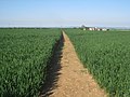
 A footpath leading to Low Farm - geograph.org.uk - 2340583.jpg 800 × 600 ; 256 kio
-

-
 Boundary bank - geograph.org.uk - 2964257.jpg 1 024 × 768 ; 187 kio
-

-

-
 Cleatham Road from Kirton Road - geograph.org.uk - 5785049.jpg 1 600 × 1 003 ; 550 kio
-
 Cleatham track in summer - geograph.org.uk - 2723971.jpg 800 × 600 ; 418 kio
-
 Communication Mast at Electricity Sub station - geograph.org.uk - 2985329.jpg 682 × 1 024 ; 206 kio
-
 Cornwall Street, Kirton in Lindsey (B1206) - geograph.org.uk - 3918254.jpg 640 × 480 ; 52 kio
-
 Crossing the railway - geograph.org.uk - 2320980.jpg 1 024 × 768 ; 363 kio
-
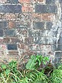 Cut bench mark on Kirton in Lindsey railway bridge - geograph.org.uk - 6270966.jpg 960 × 1 280 ; 461 kio
-
 Disused pits near Cleatham - geograph.org.uk - 2321414.jpg 1 024 × 768 ; 184 kio
-

-
 Effigy of Sir Gilbert Waterhouse, St Andrew's church - geograph.org.uk - 4472329.jpg 3 696 × 2 448 ; 2,2 Mio
-
 Entrance to Grange Farm, Kirton in Lindsey - geograph.org.uk - 4535995.jpg 640 × 427 ; 95 kio
-
 Farm track near Cliff Farm - geograph.org.uk - 3918375.jpg 640 × 480 ; 86 kio
-
 Farm track near Kirton in Lindsey - geograph.org.uk - 1452471.jpg 640 × 463 ; 44 kio
-
 Farm track, Cleatham - geograph.org.uk - 3918913.jpg 640 × 480 ; 74 kio
-
 Flowers in the churchyard, Kirton in Lindsey - geograph.org.uk - 4536019.jpg 640 × 427 ; 130 kio
-
 Fly-tip and limestone quarry - geograph.org.uk - 2723960.jpg 600 × 800 ; 385 kio
-
 Footbridge near Ings Farm - geograph.org.uk - 2331170.jpg 1 024 × 768 ; 212 kio
-
 Footbridge near Kirton Lindsey - geograph.org.uk - 2945577.jpg 1 024 × 768 ; 237 kio
-
 Footpath across railway lines. - geograph.org.uk - 6096456.jpg 1 024 × 683 ; 269 kio
-
 Footpath off Kirton Road, Cleatham - geograph.org.uk - 3800405.jpg 1 024 × 806 ; 254 kio
-
 Footpath to Hibaldstow - geograph.org.uk - 2964100.jpg 1 024 × 768 ; 247 kio
-
 Footpath to Hibaldstow - geograph.org.uk - 3726188.jpg 1 024 × 768 ; 223 kio
-
 Footpath to Kirton - geograph.org.uk - 2321428.jpg 1 024 × 768 ; 220 kio
-
 Footpath to Sweet Hills - geograph.org.uk - 2945570.jpg 1 024 × 768 ; 170 kio
-
 Former Baptist church, Kirton in Lindsey - geograph.org.uk - 6324733.jpg 1 727 × 2 706 ; 1,13 Mio
-
 Former R.A.F. Kirton in Lindsey, aerial - geograph.org.uk - 3881945.jpg 1 024 × 610 ; 88 kio
-
 Gainsthorpe DMV, aerial 2018 - geograph.org.uk - 5980061.jpg 640 × 427 ; 74 kio
-
 Gap in the trees - geograph.org.uk - 2675690.jpg 1 024 × 768 ; 230 kio
-
 Garden scene, Kirton in Lindsey - geograph.org.uk - 4536017.jpg 427 × 640 ; 48 kio
-
 Gas valve station - geograph.org.uk - 3740493.jpg 1 024 × 768 ; 178 kio
-
 Grayingham Low Road - geograph.org.uk - 2319744.jpg 1 024 × 768 ; 113 kio
-
 Grazing, Park Farm - geograph.org.uk - 3918268.jpg 640 × 480 ; 68 kio
-

-
 Household Refuse Site, Kirton-in-Lindsey - geograph.org.uk - 217218.jpg 640 × 480 ; 71 kio
-
 I don't think so ^ - geograph.org.uk - 2321600.jpg 1 024 × 768 ; 284 kio
-
 Kirton Cliff Farm - geograph.org.uk - 2964248.jpg 1 024 × 768 ; 268 kio
-
 Kirton in Lindsey - stile on North Cliff Road - geograph.org.uk - 2455745.jpg 1 600 × 1 200 ; 513 kio
-
 Kirton in Lindsey railway bridge - geograph.org.uk - 6270974.jpg 1 280 × 960 ; 340 kio
-
 Kirton in Lindsey Station - geograph.org.uk - 2619400.jpg 640 × 397 ; 92 kio
-
 Kirton in Lindsey War Memorial - geograph.org.uk - 6269832.jpg 3 072 × 4 608 ; 1,51 Mio
-
 Kirton Lime Sidings, aerial 2018 (2) - geograph.org.uk - 5981163.jpg 640 × 427 ; 67 kio
-
 Kirton Lindsey airfield - geograph.org.uk - 2981821.jpg 640 × 427 ; 64 kio
-
 Kirton Lindsey RAF camp - geograph.org.uk - 355499.jpg 640 × 424 ; 55 kio
-
 Kirton Road near Low Farm - geograph.org.uk - 5785042.jpg 1 600 × 1 099 ; 500 kio
-
 Kirton Tunnel, Kirton in Lindsey - geograph.org.uk - 4536041.jpg 640 × 427 ; 100 kio
-
 Kirton view - geograph.org.uk - 698068.jpg 640 × 427 ; 61 kio
-
 Kirton-in-Lindsey, George Hotel - geograph.org.uk - 44550.jpg 640 × 480 ; 91 kio
-
 Lay-by near Cliff Farm - geograph.org.uk - 2675684.jpg 1 024 × 768 ; 260 kio
-
 Lincolnshire landscape near Kirton - geograph.org.uk - 544992.jpg 640 × 480 ; 113 kio
-
 Lone tree, Taumberland, Swineshead, Lincs - geograph.org.uk - 132684.jpg 640 × 477 ; 280 kio
-
 Manton Sewer - geograph.org.uk - 2331209.jpg 1 024 × 768 ; 200 kio
-

-
 Mount Pleasant Mill, Kirton in Lindsey - geograph.org.uk - 6324749.jpg 3 648 × 1 744 ; 2,97 Mio
-
 Nebraska Farm - geograph.org.uk - 2331032.jpg 1 024 × 768 ; 96 kio
-
 Nebraska Wood - geograph.org.uk - 334344.jpg 640 × 480 ; 49 kio
-
 New nature reserve - geograph.org.uk - 2331078.jpg 1 024 × 768 ; 133 kio
-
 New plantations near Manton Sewer - geograph.org.uk - 2331229.jpg 1 024 × 768 ; 157 kio
-
 Northcliffe Farm - geograph.org.uk - 3726204.jpg 1 024 × 768 ; 172 kio
-

-
 On the path to Hibaldstow - geograph.org.uk - 3726195.jpg 1 024 × 768 ; 144 kio
-
 On the right is Town Hall Passage - geograph.org.uk - 3800698.jpg 1 024 × 615 ; 167 kio
-
 One square, three farms - Bell Farm - geograph.org.uk - 3781667.jpg 1 024 × 768 ; 136 kio
-
 One square, three farms - Springfield Farm - geograph.org.uk - 3781672.jpg 1 024 × 768 ; 107 kio
-
 One square, three farms - Whitehoe Farm - geograph.org.uk - 3781675.jpg 1 024 × 768 ; 151 kio
-
 Outbuildings at Black House - geograph.org.uk - 2332120.jpg 1 024 × 768 ; 184 kio
-
 Path across the railway, Kirton in Lindsey - geograph.org.uk - 4536048.jpg 640 × 427 ; 107 kio
-
 Plantation by Ermine Street - geograph.org.uk - 3740476.jpg 1 024 × 768 ; 143 kio
-

-
 Playing fields alongside B1400 Kirton in Lindsey - geograph.org.uk - 4719409.jpg 1 024 × 719 ; 105 kio
-
 Public Bridleway at Kirton-in-Lindsey - geograph.org.uk - 544655.jpg 480 × 640 ; 134 kio
-
 Public footpath to Sweet Hills - geograph.org.uk - 1425923.jpg 640 × 480 ; 50 kio
-
 Rail bridge on Cleatham Road, Kirton Lindsey - geograph.org.uk - 5785057.jpg 1 600 × 1 204 ; 621 kio
-

-
 Railway bridge over Kirton Road, B1400 - geograph.org.uk - 3800422.jpg 1 024 × 675 ; 96 kio
-
 Redbourne Mere towards the A15 - geograph.org.uk - 5785195.jpg 1 600 × 1 125 ; 443 kio
-
 Redbourne Mere towards the A15 - geograph.org.uk - 5785200.jpg 1 600 × 1 061 ; 425 kio
-
 Roadworks Kirton in Lindsey - geograph.org.uk - 4719405.jpg 1 024 × 636 ; 119 kio
-
 Royal Air Force 1939-1945- Fighter Command CH885.jpg 800 × 557 ; 33 kio
-
 Sign of The Queen's Head, Kirton in Lindsey - geograph.org.uk - 6269827.jpg 4 608 × 3 072 ; 5,41 Mio
-
 South Cliff Road, Kirton in Lindsey - geograph.org.uk - 3918272.jpg 640 × 480 ; 101 kio
-
 Springfield Farm - geograph.org.uk - 3918142.jpg 640 × 480 ; 48 kio
-
 St Andrew's Road, Kirton in Lindsey - geograph.org.uk - 5902492.jpg 1 600 × 1 065 ; 674 kio
-
 St Andrew's United Church, Kirton in Lindsey - geograph.org.uk - 5785087.jpg 1 600 × 1 065 ; 568 kio
-
 St Andrew's United Church, Kirton in Lindsey - geograph.org.uk - 5902252.jpg 1 600 × 1 065 ; 556 kio
-
 St Andrew's United Church, Kirton in Lindsey - geograph.org.uk - 5902283.jpg 915 × 1 600 ; 388 kio
-
 St Andrew's United Church, Kirton in Lindsey - geograph.org.uk - 5902286.jpg 1 065 × 1 600 ; 475 kio
-
 St Andrew's United Church, Kirton in Lindsey - geograph.org.uk - 5902290.jpg 1 065 × 1 600 ; 475 kio
-
 St Andrew's United Church, Kirton in Lindsey - geograph.org.uk - 5902292.jpg 496 × 1 600 ; 335 kio
-
 St Andrew's United Church, Kirton in Lindsey - geograph.org.uk - 5902293.jpg 470 × 1 600 ; 338 kio
-
 St Andrew's United Church, Kirton in Lindsey - geograph.org.uk - 5902295.jpg 1 469 × 1 600 ; 796 kio
-
 St Andrew's United Church, Kirton in Lindsey - geograph.org.uk - 5902296.jpg 479 × 1 600 ; 236 kio
-
 St Andrew's United Church, Kirton in Lindsey - geograph.org.uk - 5902297.jpg 427 × 1 600 ; 284 kio
-
 St Andrew's United Church, Kirton in Lindsey - geograph.org.uk - 5902299.jpg 600 × 1 600 ; 369 kio
-
 St Andrew's United Church, Kirton in Lindsey - geograph.org.uk - 5902301.jpg 1 231 × 1 600 ; 730 kio
-
 St Andrew's United Church, Kirton in Lindsey - geograph.org.uk - 5902375.jpg 851 × 1 600 ; 644 kio
-
 St Andrew's United Church, Kirton in Lindsey - geograph.org.uk - 5902404.jpg 1 291 × 1 600 ; 703 kio
-
 St Andrew's United Church, Kirton in Lindsey - geograph.org.uk - 5902405.jpg 1 065 × 1 600 ; 469 kio
-
 St Andrew's United Church, Kirton in Lindsey - geograph.org.uk - 5902487.jpg 853 × 1 600 ; 490 kio
-
 St Andrew's United Church, Kirton in Lindsey - geograph.org.uk - 5902489.jpg 1 600 × 1 065 ; 579 kio
-
 St Andrew's United Church, Kirton in Lindsey - geograph.org.uk - 5902490.jpg 1 600 × 1 065 ; 466 kio
-
 St. Andrew's United Church, Kirton in Lindsey - geograph.org.uk - 6324726.jpg 3 505 × 1 675 ; 1,32 Mio
-
 Steps down to the railway - geograph.org.uk - 2320958.jpg 1 024 × 768 ; 348 kio
-
 Steps up to the railway - geograph.org.uk - 2331106.jpg 1 024 × 768 ; 207 kio
-

-
 The bridleway near Cliff Farm - geograph.org.uk - 3740465.jpg 1 024 × 768 ; 112 kio
-
 The end of the line - geograph.org.uk - 3740469.jpg 1 024 × 768 ; 86 kio
-
 The farm track to Ings Farm - geograph.org.uk - 2331204.jpg 1 024 × 768 ; 137 kio
-
 The footpath between Kirton in Lindsey and Scotton - geograph.org.uk - 2331218.jpg 1 024 × 768 ; 219 kio
-
 The footpath to Scotton - geograph.org.uk - 2331094.jpg 1 024 × 768 ; 143 kio
-
 The footpath to Scotton - geograph.org.uk - 2331180.jpg 1 024 × 768 ; 236 kio
-
 The footpath to Scotton - geograph.org.uk - 2331186.jpg 1 024 × 768 ; 165 kio
-
 The footpath to Scotton - geograph.org.uk - 2331195.jpg 1 024 × 768 ; 140 kio
-
 The footpath to Scotton on the return - geograph.org.uk - 2331153.jpg 1 024 × 768 ; 175 kio
-
 The footpath to Scotton out - geograph.org.uk - 2331137.jpg 1 024 × 768 ; 174 kio
-
 The gates of RAF Kirton in Lindsey all locked up - geograph.org.uk - 6269864.jpg 4 608 × 3 072 ; 3,24 Mio
-
 The Green, Kirton in Lindsey - geograph.org.uk - 6324735.jpg 3 648 × 1 744 ; 2,91 Mio
-
 The junction of Cleatham Road with Kirton Road - geograph.org.uk - 2340594.jpg 800 × 600 ; 214 kio
-
 The junction of the B1205 and B1206 - geograph.org.uk - 2350466.jpg 800 × 600 ; 243 kio
-
 The Queen's Head, Kirton in Lindsey - geograph.org.uk - 6269826.jpg 4 608 × 3 072 ; 5,33 Mio
-
 The steps on the other side - geograph.org.uk - 2331128.jpg 1 024 × 768 ; 218 kio
-
 The War memorial at Kirton in Lindsey from The Green - geograph.org.uk - 6269834.jpg 4 608 × 3 072 ; 5,39 Mio
-
 The way to Cliff Farm on Redbourne Mere (road) - geograph.org.uk - 2350766.jpg 800 × 600 ; 234 kio
-

-
 Thorpe House - geograph.org.uk - 6324721.jpg 3 648 × 1 744 ; 2,89 Mio
-
 Torksey Street, Kirton in Lindsey - geograph.org.uk - 5902248.jpg 1 600 × 1 065 ; 561 kio
-
 Towards Cleatham - geograph.org.uk - 324449.jpg 640 × 427 ; 40 kio
-
 Track away from Northcliffe Farm - geograph.org.uk - 6324769.jpg 3 648 × 1 744 ; 2,95 Mio
-
 Track by Northcliffe Farm - geograph.org.uk - 6324764.jpg 3 648 × 1 744 ; 3,15 Mio
-
 Track to Cleatham - geograph.org.uk - 324408.jpg 640 × 427 ; 90 kio
-
 Track to Mount Pleasant - geograph.org.uk - 1425926.jpg 640 × 480 ; 67 kio
-
 Track to North Cliff Road - geograph.org.uk - 2321442.jpg 1 024 × 768 ; 214 kio
-
 Track to Whitehoe Farm - geograph.org.uk - 4008809.jpg 3 536 × 2 416 ; 5,45 Mio
-
 Train Gate at Queen Street, Kirton in Lindsey - geograph.org.uk - 2350737.jpg 800 × 600 ; 306 kio
-

-
 View along the tracks - geograph.org.uk - 2331116.jpg 1 024 × 768 ; 173 kio
-
 View from Grayingham Low Road - geograph.org.uk - 181837.jpg 640 × 427 ; 52 kio
-
 View towards Kirton Lindsey - geograph.org.uk - 2945581.jpg 1 024 × 768 ; 201 kio
-
 View towards Kirton Tunnel - geograph.org.uk - 2320945.jpg 1 024 × 768 ; 282 kio
-
 View towards Mount Pleasant - geograph.org.uk - 2321588.jpg 1 024 × 768 ; 188 kio
-
 View towards Pilfoot Farm - geograph.org.uk - 2964105.jpg 1 024 × 768 ; 178 kio
-
 View towards South Cliff Farm and Kirton army base - geograph.org.uk - 2319738.jpg 1 024 × 768 ; 147 kio
-
 View towards the crossroads at Cleatham - geograph.org.uk - 2321574.jpg 1 024 × 768 ; 148 kio
-
 View towards the hide - geograph.org.uk - 2331052.jpg 1 024 × 768 ; 139 kio
-
 View towards the River Eau - geograph.org.uk - 2331045.jpg 1 024 × 768 ; 164 kio
-
 View towards White Hoe Farm - geograph.org.uk - 2945630.jpg 1 024 × 768 ; 186 kio
-
 Wheatfield but no crows - geograph.org.uk - 2964118.jpg 1 024 × 768 ; 169 kio
-
 White Hoe Farm - geograph.org.uk - 3918139.jpg 640 × 480 ; 47 kio
-
 Woodland beside the B1205 - geograph.org.uk - 3918366.jpg 640 × 480 ; 59 kio
-
 WWII Eagle Sqn's Memorial - geograph.org.uk - 3711636.jpg 3 648 × 2 736 ; 4,76 Mio


_-_geograph.org.uk_-_3918254.jpg)


_-_geograph.org.uk_-_5981163.jpg)


_-_geograph.org.uk_-_2350766.jpg)


,_Kirton_in_Lindsey_-_geograph.org.uk_-_3918255.jpg)


