Category:Kunoy
Vai alla navigazione
Vai alla ricerca

island in the Faroe Islands   | |||||
| Carica un file multimediale | |||||
| Istanza di | |||||
|---|---|---|---|---|---|
| Parte di | |||||
| Luogo | Kunoy Municipality, Norðoyar | ||||
| Situato sul mare / lago / fiume | |||||
| Punto più alto |
| ||||
| Popolazione |
| ||||
| Superficie |
| ||||
| Altezza sul mare |
| ||||
| Distinto da | |||||
| sito web ufficiale | |||||
 | |||||
Sottocategorie
Questa categoria contiene le 6 sottocategorie indicate di seguito, su un totale di 6.
Pagine nella categoria "Kunoy"
Questa categoria contiene un'unica pagina, indicata di seguito.
File nella categoria "Kunoy"
Questa categoria contiene 38 file, indicati di seguito, su un totale di 38.
-
 Bus routes on the northern islands (map, Faroe).jpg 573 × 644; 99 KB
-
 Causeway Kunoy.JPG 3 888 × 2 592; 3,09 MB
-
 Detailed map kunoy 2006.jpg 614 × 886; 185 KB
-
 Faroe Islands Føroyar Færøerne Wyspy Owcze 2019 (1).jpg 1 500 × 844; 1,45 MB
-
 Faroe stamp 352 kunoy.jpg 447 × 306; 35 KB
-
 Faroe stamp 486 maria cruise - sunnari enda a kunoynni.jpg 367 × 247; 46 KB
-
 Faroenature Kunoy.jpg 640 × 426; 94 KB
-
 FaroeseRamKunoy.JPG 3 072 × 2 304; 3,03 MB
-
 Fjall í Færeyjum.jpg 4 608 × 2 592; 2,03 MB
-
 Haraldssund, Faroe Islands (3).JPG 2 560 × 1 704; 2,52 MB
-
 Harbour of klaksvik, faroe islands.jpg 768 × 511; 116 KB
-
 Kalsoy from Klakkur.jpg 3 648 × 2 736; 4,34 MB
-
 Kittiwakes at Kalsoy.jpg 4 256 × 2 848; 2,69 MB
-
 Klaksvík Kunoy 1.JPG 3 444 × 2 586; 5,57 MB
-
 Klaksvík Kunoy 2.JPG 3 444 × 2 586; 5,48 MB
-
 Klaksvík Kunoy 3.JPG 3 444 × 2 586; 4,79 MB
-
 Klaksvík Kunoy 4.JPG 3 444 × 2 586; 4,63 MB
-
 Klaksvík Kunoy 5.JPG 3 444 × 2 586; 4,98 MB
-
 Klaksvík Kunoy 6.JPG 3 444 × 2 586; 4,84 MB
-
 Klaksvík otbp banner 3.jpg 2 144 × 715; 650 KB
-
 Klaksvík.2010.1.jpg 3 872 × 2 592; 2,27 MB
-
 Kunoy bygd.1.jpg 2 560 × 1 704; 848 KB
-
 Kunoy Faroe Islands 2019.jpg 4 032 × 3 024; 2,96 MB
-
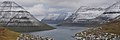
 Kunoy from the Ocean.jpg 4 256 × 2 848; 3,44 MB
-
 Kunoy kort.png 569 × 795; 75 KB
-
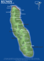
 Kunoy map.jpg 569 × 795; 97 KB
-
 Kunoy natur.5.jpg 640 × 426; 24 KB
-
 Kunoy Tunnel, Faroe Islands.jpg 2 213 × 3 327; 7,27 MB
-
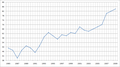 Kunoy Village Demography (1985-2009).png 798 × 448; 20 KB
-
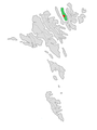
 Kunoy village on Faroe map.png 688 × 1 035; 24 KB
-
 Kunoy, Faroe Islands (6).JPG 2 560 × 1 704; 1,15 MB
-
 Kunoy.jpg 2 560 × 1 704; 1,57 MB
-
 Kunoyarnes A-12.jpg 4 977 × 2 612; 8,32 MB
-
 Map-position-kunoyar-kommuna-2005.png 600 × 800; 24 KB
-
 Panorama of Klaksvik.jpg 3 648 × 2 736; 4,63 MB
-
 Position of Kunoy on Faroe map.png 688 × 1 035; 19 KB
-
 Stamps of the Faroe Islands-14.jpg 692 × 913; 557 KB
-
 Trøllanes Kalsoy.3.jpg 1 995 × 1 325; 331 KB
.jpg)


.jpg)


.JPG)


.png)

.JPG)


