Category:La Sauvetat (Gers)
Vai alla navigazione
Vai alla ricerca
comune francese .JPG) .svg)  | |||||
| Carica un file multimediale | |||||
| Istanza di | |||||
|---|---|---|---|---|---|
| Luogo |
| ||||
| Indirizzo stradale |
| ||||
| Popolazione |
| ||||
| Superficie |
| ||||
| Altezza sul mare |
| ||||
| Distinto da | |||||
 | |||||
Sottocategorie
Questa categoria contiene le 4 sottocategorie indicate di seguito, su un totale di 4.
C
- Château de Sérillac (15 F)
E
L
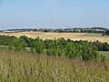
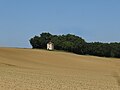
- Landscapes of La Sauvetat (9 F)
M
- Maps of La Sauvetat (Gers) (4 F)
File nella categoria "La Sauvetat (Gers)"
Questa categoria contiene 14 file, indicati di seguito, su un totale di 14.
-
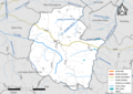 32417-La Sauvetat-Routes-Hydro.png 3 507 × 2 480; 1,97 MB
-
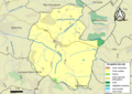 32417-La Sauvetat-Sols.png 3 507 × 2 480; 2,01 MB
-
 Blason ville fr La Sauvetat (Gers).svg 600 × 660; 20 KB
-
 La Sauvetat 2021 01.jpg 4 892 × 2 752; 2,07 MB
-
 La Sauvetat 2021 02.jpg 4 896 × 3 672; 4,77 MB
-
 La Sauvetat 2021 03.jpg 4 535 × 3 401; 2,47 MB
-
 La Sauvetat 2021 04.jpg 4 896 × 3 672; 4,67 MB
-
 La Sauvetat 2021 05.jpg 4 104 × 2 309; 1,53 MB
-
 La Sauvetat 2021 06.jpg 4 821 × 2 711; 1,95 MB
-
 La Sauvetat 2021 07.jpg 4 896 × 3 672; 5 MB
-
 La Sauvetat 2021 08.jpg 4 896 × 3 672; 4,15 MB
-
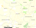 Map commune FR insee code 32417.png 756 × 605; 39 KB
-
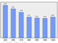 Population - Municipality code 32417.svg 475 × 355; 13 KB
-
 Vue Aerienne de la Sauvetat.jpg 2 048 × 1 365; 1,22 MB


