Category:Lake Bonneville
Zur Navigation springen
Zur Suche springen
former pluvial lake in what is now Utah, Nevada, and Idaho in the United States  jezerní terasy vzniklé po ústupu jezera Bonneville na ostrově Antelope na Velkém Solném jezeře v Utahu | |||||
| Medium hochladen | |||||
| Ist ein(e) |
| ||||
|---|---|---|---|---|---|
| Benannt nach | |||||
| Ort | |||||
| Fläche |
| ||||
 | |||||
English: Media related to Lake Bonneville, a former pluvial lake in what is now Utah, Nevada, and Idaho in the United States.
Unterkategorien
Es werden 8 von insgesamt 8 Unterkategorien in dieser Kategorie angezeigt:
In Klammern die Anzahl der enthaltenen Kategorien (K), Seiten (S), Dateien (D)
Medien in der Kategorie „Lake Bonneville“
Folgende 39 Dateien sind in dieser Kategorie, von 39 insgesamt.
-
 1 map of Pleistocene lakes in the Great Basin.png 3.600 × 4.200; 929 KB
-
 2007 01 11 lav-slc 051 (354819928).jpg 3.504 × 2.336; 4,31 MB
-
 2014, Wendover Will and Wendover, Bonneville Lake - panoramio.jpg 6.000 × 4.000; 6,88 MB
-
 2014, West Wendover Historical Markers - panoramio.jpg 6.000 × 4.000; 10,5 MB
-

-
 A section of Lake Bonneville, Idaho.jpg 4.032 × 3.024; 5,6 MB
-
 A sign for Lake Bonneville, Utah.jpg 3.024 × 4.032; 4,66 MB
-
 American Fork Canyon and view of Bonneville terrace.jpg 3.166 × 1.837; 3,43 MB
-
 Ancient Lakes 2016-10-13 2318.jpg 4.608 × 3.072; 3,55 MB
-
 Antelope Island - panoramio.jpg 2.160 × 1.440; 375 KB
-
 Antelope Island Cove 2005.jpg 1.267 × 941; 951 KB
-
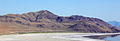
 Black Rock Desert volcanic field.jpg 1.024 × 679; 365 KB
-
 Bonneville Flut2.jpg 520 × 420; 55 KB
-
 Chronology of Lake Bonneville.png 2.026 × 1.482; 119 KB
-
 FMIB 39503 Map of the Quaternary Lakes, Bonneville and Labontan.jpeg 763 × 563; 96 KB
-
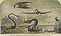
 FMIB 51613 Ancient Outlet of Lake Bonneville, Great Salt Lake, in Idaho.jpeg 1.277 × 768; 371 KB
-
 Geology (1907) (14776577225).jpg 2.264 × 3.636; 849 KB
-
 Lake Bonneville flood bed.png 268 × 401; 209 KB
-
 Lake Bonneville lake level oscillations.jpg 11.772 × 7.490; 7,25 MB
-
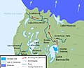
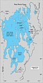
 Lake Bonneville map de cropped.svg 522 × 376; 44 KB
-
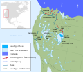 Lake Bonneville map de.svg 663 × 570; 352 KB
-
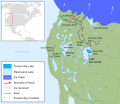 Lake bonneville map.svg 663 × 570; 352 KB
-
 Lake Bonneville Pleistoceen.jpg 680 × 588; 181 KB
-
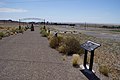
 LakeBonnevilleRestStop.jpg 1.536 × 1.024; 413 KB
-
 Lk Bonneville & Provo 4847.jpg 6.000 × 4.000; 9,85 MB
-
 Lk Stansbury, Gilbert & Gt Salt 4848.jpg 6.000 × 4.000; 10,1 MB
-
 Map of Lake Bonneville.jpg 1.032 × 1.959; 133 KB
-
 Plate 13 Lake Bonneville.jpg 1.383 × 1.989; 336 KB
-
 Plate 14 Provo Shoreline.jpg 1.392 × 1.996; 299 KB
-
 Plate 26 Map of the Deltas formed in of Lake Bonnevlle of the Logan River.jpg 1.347 × 1.828; 197 KB
-
 Plate 28 Outlet of Lake Bonneville at Red Rock Pass.jpg 1.393 × 1.937; 306 KB
-
 Plate 3 Map of Lake Bonneville.jpg 1.400 × 2.020; 320 KB
-
 Plate 41 Map of Lake Bonneville showing the Distribution of Basalt.jpg 1.373 × 1.938; 278 KB
-
 Plate 6 Cup Butte, a feature on Lake Bonneville.jpg 1.472 × 1.023; 273 KB
-
-
 Surge wave debris field.jpg 8.256 × 5.504; 31,61 MB
-

-
 The Worlds Fastest Place - Book Cover.jpg 2.362 × 1.575; 1,69 MB
-
 WaveCutPlatformsAntelopeIslandUT.jpg 1.500 × 518; 140 KB

.jpg)


_in_Elko_County,_Nevada.jpg)


_(14776577225).jpg)


_(14591971357).jpg)


Kategorien:
- Pleistocene geology of North America
- Geology of the United States
- Ice age flood events
- Pleistocene geography
- Ice-age glacial lakes of North America
- Former lakes of Utah
- Former lakes of Nevada
- Former lakes of Idaho
- Quaternary glaciations in Idaho
- Quaternary glaciations in Nevada
- Quaternary glaciations in Utah
- Pleistocene lakes in North America