Category:Lapley, Stretton and Wheaton Aston
Aller à la navigation
Aller à la recherche
English: Lapley, Stretton and Wheaton Aston is a civil parish in the South Staffordshire district, in the county of Staffordshire, England.
localité britannique du comté anglais de Staffordshire  | |||||
| Téléverser des médias | |||||
| Nature de l’élément | |||||
|---|---|---|---|---|---|
| Nommé(e) en référence à | |||||
| Lieu | South Staffordshire, Staffordshire, Midlands de l'Ouest, Angleterre | ||||
 | |||||
Sous-catégories
Cette catégorie comprend 7 sous-catégories, dont les 7 ci-dessous.
L
- Longnor Hall, Staffordshire (4 F)
- Longnor, South Staffordshire (1 F)
S
- Stretton Hall, Staffordshire (1 F)
W
Média dans la catégorie « Lapley, Stretton and Wheaton Aston »
Cette catégorie comprend 349 fichiers, dont les 200 ci-dessous.
(page précédente) (page suivante)-

-
 A Field of Maize on the side of the A5 - geograph.org.uk - 2589222.jpg 640 × 428 ; 86 kio
-
 A fishing pool at Lucknow Farm - geograph.org.uk - 2949542.jpg 1 142 × 857 ; 403 kio
-
 A slight diversion to the bridleway - geograph.org.uk - 3975995.jpg 816 × 612 ; 194 kio
-
 A small pond near Hurst Plantation - geograph.org.uk - 2949518.jpg 1 142 × 857 ; 467 kio
-
 About to leave a field - geograph.org.uk - 2031597.jpg 640 × 480 ; 165 kio
-
 Across fields to Stretton Wood - geograph.org.uk - 4061090.jpg 1 142 × 857 ; 333 kio
-
 Across the fields south of Shushions Manor - geograph.org.uk - 2949560.jpg 1 142 × 857 ; 331 kio
-
 All Saints Church, Lapley - geograph.org.uk - 4899253.jpg 1 200 × 799 ; 475 kio
-
 All Saints Church, Lapley - geograph.org.uk - 4899254.jpg 1 200 × 799 ; 454 kio
-
 All Saints, Lapley - geograph.org.uk - 3977115.jpg 734 × 979 ; 336 kio
-
 Along the Shropshire Union Canal - geograph.org.uk - 5746591.jpg 800 × 643 ; 139 kio
-
 Along the southern edge of Lapley Gorse - geograph.org.uk - 4061088.jpg 1 142 × 857 ; 363 kio
-
 Another Shroppy milepost - geograph.org.uk - 3396030.jpg 979 × 734 ; 464 kio
-

-
 Aqueduct north-west of Brewood, Staffordshire - geograph.org.uk - 5820626.jpg 1 280 × 905 ; 1,22 Mio
-
 At the bend in the Penk - geograph.org.uk - 4473123.jpg 857 × 1 142 ; 396 kio
-
 At the bridleway crossroads - geograph.org.uk - 3393159.jpg 1 142 × 857 ; 380 kio
-
 At the crossroads of bridleways - geograph.org.uk - 2949546.jpg 1 306 × 979 ; 427 kio
-
 Back towards The Ivy House crossroads - geograph.org.uk - 4070477.jpg 1 142 × 857 ; 307 kio
-
 Barn conversion in Wheaton Aston, Staffordshire - geograph.org.uk - 4688603.jpg 1 024 × 768 ; 545 kio
-
 Barn conversion in Wheaton Aston, Staffordshire - geograph.org.uk - 4688606.jpg 768 × 1 024 ; 614 kio
-
 Barns at Brook House Farm - geograph.org.uk - 3393139.jpg 1 175 × 881 ; 369 kio
-
 Bell Inn on The A5 - geograph.org.uk - 3518921.jpg 640 × 434 ; 52 kio
-
 Bellhurst Lane - geograph.org.uk - 2949573.jpg 1 142 × 857 ; 239 kio
-

-
 Bend in Ivetsey Road - geograph.org.uk - 6158072.jpg 800 × 600 ; 109 kio
-
 Bickford Road towards Bickford - geograph.org.uk - 4899285.jpg 1 200 × 816 ; 437 kio
-
 Bickford Road, Lapley - geograph.org.uk - 6237659.jpg 640 × 480 ; 62 kio
-
 Boatyard near Stretton in Staffordshire - geograph.org.uk - 6019571.jpg 1 280 × 1 280 ; 1,77 Mio
-
 Boatyard north-west of Brewood, Staffordshire - geograph.org.uk - 3436556.jpg 1 024 × 708 ; 422 kio
-
 Bradford Arms on the A5 Watling Street - geograph.org.uk - 4899074.jpg 1 200 × 799 ; 331 kio
-
 Bradford Arms on the A5 Watling Street - geograph.org.uk - 4899075.jpg 938 × 1 200 ; 279 kio
-
 Bridleway and snow - geograph.org.uk - 3393151.jpg 1 142 × 857 ; 359 kio
-
 Bridleway bridge over the Longnor Brook - geograph.org.uk - 4059236.jpg 612 × 816 ; 332 kio
-
 Bridleway crossing a field near The Lights - geograph.org.uk - 3393158.jpg 1 306 × 979 ; 354 kio
-
 Bridleway east of Longnor Gorse Farm - geograph.org.uk - 3975989.jpg 612 × 816 ; 331 kio
-
 Bridleway in a field - geograph.org.uk - 3975958.jpg 734 × 979 ; 307 kio
-
 Bridleway near The Hurst - geograph.org.uk - 2949525.jpg 1 142 × 857 ; 422 kio
-
 Bridleway north of Lapley - geograph.org.uk - 3977104.jpg 1 142 × 857 ; 466 kio
-
 Bridleway off Marston Road - geograph.org.uk - 6237324.jpg 800 × 600 ; 150 kio
-
 Bridleway through the fields near Lucknow Farm - geograph.org.uk - 2949540.jpg 1 142 × 857 ; 391 kio
-
 Bridleway To Wheaton Aston - geograph.org.uk - 2323938.jpg 1 496 × 1 122 ; 752 kio
-
 Bridleway towards Lapley Wood Farm - geograph.org.uk - 3977117.jpg 734 × 979 ; 383 kio
-
 Cafe India on A5 - geograph.org.uk - 3518893.jpg 640 × 394 ; 93 kio
-
 Camping at Whitegate Farm Campsite - geograph.org.uk - 6209121.jpg 1 024 × 768 ; 214 kio
-
 Canal and farmland near Wheaton Aston in Staffordshire - geograph.org.uk - 6021038.jpg 1 440 × 960 ; 1,07 Mio
-
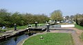 Canal and lock at Wheaton Aston, Staffordshire - geograph.org.uk - 3437013.jpg 1 280 × 707 ; 452 kio
-
 Canal at Wheaton Aston, Staffordshire - geograph.org.uk - 4680494.jpg 1 024 × 736 ; 338 kio
-
 Canal east of Wheaton Aston in Staffordshire - geograph.org.uk - 5813293.jpg 1 280 × 960 ; 1,45 Mio
-
 Canal north of Wheaton Aston in Staffordshire - geograph.org.uk - 6021162.jpg 1 440 × 1 080 ; 1,79 Mio
-
 Car sales on Watling Street (A5) - geograph.org.uk - 6158077.jpg 800 × 529 ; 69 kio
-
 Cereal crop near Whitehouse Farm - geograph.org.uk - 6237322.jpg 800 × 600 ; 116 kio
-
 Church Lane towards Lapley - geograph.org.uk - 4899249.jpg 1 200 × 838 ; 342 kio
-
 Close up, Elizabeth II postbox on Ivetsey Road, Ivetsey Bank - geograph.org.uk - 6159292.jpg 2 732 × 4 513 ; 2,63 Mio
-
 Close up, Elizabeth II postbox on Roman Road, Wheaton Aston - geograph.org.uk - 6238987.jpg 1 380 × 2 358 ; 653 kio
-
 Coach and Horses - geograph.org.uk - 4899129.jpg 1 200 × 799 ; 345 kio
-
 Coach and Horses - geograph.org.uk - 4899131.jpg 990 × 1 200 ; 344 kio
-
 Collapsed beyond all hope of repair - geograph.org.uk - 2949545.jpg 1 142 × 857 ; 505 kio
-
 Communications centre, Lapley - geograph.org.uk - 6238990.jpg 2 848 × 2 136 ; 1,36 Mio
-
 Corner cottage north of Wheaton Aston, Staffordshire - geograph.org.uk - 4684092.jpg 1 024 × 788 ; 454 kio
-
 Cornflower blooms by Watling Street - geograph.org.uk - 1883387.jpg 640 × 497 ; 151 kio
-
 Cornflower blooms by Watling Street - geograph.org.uk - 1883389.jpg 640 × 506 ; 152 kio
-
 Crop field near Stretton - geograph.org.uk - 6158113.jpg 800 × 600 ; 82 kio
-
 Crop field off The Avenue - geograph.org.uk - 6158109.jpg 800 × 600 ; 85 kio
-
 Crop field, Ivetsey Bank - geograph.org.uk - 6158074.jpg 800 × 600 ; 159 kio
-
 Crop field, Water Eaton - geograph.org.uk - 6158120.jpg 800 × 600 ; 108 kio
-

-
 Drifted snow and a hedge - geograph.org.uk - 3393162.jpg 1 469 × 1 102 ; 260 kio
-
 Elizabeth II postbox on Ivetsey Road, Ivetsey Bank - geograph.org.uk - 6159288.jpg 5 184 × 3 888 ; 4,57 Mio
-
 Elizabeth II postbox on Long Street, Wheaton Aston - geograph.org.uk - 6238992.jpg 2 136 × 2 848 ; 1,38 Mio
-
 Elizabeth II postbox on Roman Road, Wheaton Aston - geograph.org.uk - 6238986.jpg 2 136 × 2 848 ; 1,2 Mio
-
 Elizabeth II postbox, Lapley - geograph.org.uk - 6238988.jpg 2 136 × 2 848 ; 1,39 Mio
-
 End of a track from Lapley - geograph.org.uk - 4061096.jpg 979 × 734 ; 374 kio
-
 Entering Wheaton Aston - geograph.org.uk - 6237326.jpg 800 × 600 ; 146 kio
-
 Entrance to Bickford Grange Farm - geograph.org.uk - 4899295.jpg 1 200 × 799 ; 298 kio
-
 Entrance to Seven Oaks - geograph.org.uk - 2589067.jpg 640 × 428 ; 108 kio
-
 Entrance to Sunnybank Caravan Park - geograph.org.uk - 2467260.jpg 640 × 428 ; 79 kio
-

-
 Farm land by Watling Street at Stretton, Staffordshire - geograph.org.uk - 4768853.jpg 1 280 × 797 ; 601 kio
-
 Farm land near Stretton, Staffordshire - geograph.org.uk - 4768930.jpg 1 280 × 755 ; 518 kio
-
 Farm land near Stretton, Staffordshire - geograph.org.uk - 4768934.jpg 1 280 × 872 ; 698 kio
-
 Farm land north-west of Brewood in Staffordshire - geograph.org.uk - 5820729.jpg 1 280 × 960 ; 1,21 Mio
-
 Farm track beside Pool Plantation - geograph.org.uk - 3977099.jpg 1 142 × 857 ; 442 kio
-
 Farm track north of Lapley - geograph.org.uk - 4059290.jpg 1 142 × 857 ; 378 kio
-
 Farmland and house west of Lapley, Staffordshire - geograph.org.uk - 4688124.jpg 1 024 × 683 ; 414 kio
-
 Farmland east of Wheaton Aston, Staffordshire - geograph.org.uk - 4686283.jpg 1 280 × 842 ; 838 kio
-
 Farmland east of Wheaton Aston, Staffordshire - geograph.org.uk - 4686288.jpg 1 280 × 842 ; 480 kio
-
 Farmland near Stretton, Staffordshire - geograph.org.uk - 3494191.jpg 1 024 × 712 ; 394 kio
-
 Farmland near Water Eaton - geograph.org.uk - 4910593.jpg 1 600 × 1 064 ; 427 kio
-
 Farmland north of Brewood, Staffordshire - geograph.org.uk - 3817071.jpg 1 280 × 960 ; 862 kio
-
 Farmland north of Brewood, Staffordshire - geograph.org.uk - 3817076.jpg 1 280 × 718 ; 515 kio
-
 Farmland north-east of Wheaton Aston, Staffordshire - geograph.org.uk - 4688112.jpg 1 280 × 778 ; 711 kio
-
 Farmland west of Lapley, Staffordshire - geograph.org.uk - 4687837.jpg 1 024 × 683 ; 627 kio
-
 Fenton House Lane, Wheaton Aston - geograph.org.uk - 6237328.jpg 800 × 600 ; 87 kio
-
 Field of barley east of Stretton Park - geograph.org.uk - 4070475.jpg 1 142 × 857 ; 409 kio
-
 Fields east of Lapley, Staffordshire - geograph.org.uk - 4687451.jpg 1 280 × 886 ; 799 kio
-
 Fields east of Lapley, Staffordshire - geograph.org.uk - 4687821.jpg 768 × 1 024 ; 665 kio
-
 Fields east of Wheaton Aston, Staffordshire - geograph.org.uk - 4687378.jpg 1 024 × 701 ; 550 kio
-
 Fields near Water Eaton - geograph.org.uk - 4473117.jpg 1 142 × 857 ; 394 kio
-
 Fields on the side of Roman Road - geograph.org.uk - 2475507.jpg 640 × 428 ; 62 kio
-
 Fields west of Lapley, Staffordshire - geograph.org.uk - 4686804.jpg 1 280 × 872 ; 932 kio
-
 Fields west of Lapley, Staffordshire - geograph.org.uk - 4686818.jpg 1 280 × 872 ; 881 kio
-
 Finished for the day, Staffordshire - geograph.org.uk - 4688149.jpg 1 280 × 704 ; 558 kio
-
 Foggy morning at Wheaton Aston, Staffordshire - geograph.org.uk - 4680503.jpg 1 024 × 768 ; 290 kio
-
 Footpath at Ivetsey Bank - geograph.org.uk - 2949514.jpg 1 142 × 857 ; 475 kio
-
 Footpath Junction At Ivetsey Bank - geograph.org.uk - 2322825.jpg 1 496 × 1 122 ; 718 kio
-
 Footpath Near Ivetsey Bank - geograph.org.uk - 2321786.jpg 1 496 × 1 122 ; 924 kio
-
 Footpath Near Ivetsey Bank - geograph.org.uk - 2322241.jpg 1 496 × 1 122 ; 461 kio
-
 Footpath Near Ivetsey Bank - geograph.org.uk - 2322248.jpg 1 496 × 1 122 ; 650 kio
-
 Footpath to the Stubbers - geograph.org.uk - 2600967.jpg 640 × 480 ; 166 kio
-
 Footpath To Wheaton Aston - geograph.org.uk - 2319894.jpg 1 496 × 1 122 ; 780 kio
-
 Footpath To Wheaton Aston - geograph.org.uk - 2319924.jpg 1 496 × 1 122 ; 813 kio
-
 Footpath To Wheaton Aston - geograph.org.uk - 2320716.jpg 1 496 × 1 122 ; 989 kio
-
 Footpath To Wheaton Aston - geograph.org.uk - 2320719.jpg 1 496 × 1 122 ; 790 kio
-
 Footpath To Wheaton Aston - geograph.org.uk - 2320722.jpg 1 496 × 1 122 ; 721 kio
-
 Footpath To Wheaton Aston - geograph.org.uk - 2323930.jpg 1 496 × 1 122 ; 776 kio
-
 Footpath To Wheaton Aston - geograph.org.uk - 2323934.jpg 1 496 × 1 122 ; 1,15 Mio
-
 Former garage at Horsebrook junction - geograph.org.uk - 4475710.jpg 1 142 × 857 ; 345 kio
-
 From Whiston, a lane running southwards - geograph.org.uk - 4072301.jpg 857 × 1 142 ; 380 kio
-
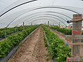 Fruit bushes in polytunnels near Lapley - geograph.org.uk - 3977096.jpg 1 142 × 857 ; 428 kio
-
 Fruit trees under cover near Lapley - geograph.org.uk - 6237636.jpg 800 × 600 ; 112 kio
-
 Fuel pump - not for use in your car - geograph.org.uk - 2804912.jpg 600 × 800 ; 250 kio
-
 Garage on Long Street, Wheaton Aston - geograph.org.uk - 4899217.jpg 1 200 × 799 ; 440 kio
-
 Gated farm track - geograph.org.uk - 6158092.jpg 800 × 600 ; 125 kio
-
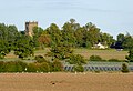
 Gatehouse for Stretton Hall - geograph.org.uk - 6158112.jpg 800 × 471 ; 103 kio
-
 Gathering in the harvest at Longnor Farm near Lapley - geograph.org.uk - 5233249.jpg 5 184 × 2 920 ; 5,09 Mio
-
 Grass field north-east of Wheaton Aston, Staffordshire - geograph.org.uk - 4685321.jpg 1 024 × 674 ; 550 kio
-
 Grazing near the River Penk - geograph.org.uk - 6158122.jpg 800 × 488 ; 58 kio
-
 Grazing near Wheaton Aston - geograph.org.uk - 6237625.jpg 800 × 600 ; 104 kio
-
 Grazing off Roman Road near Lapley - geograph.org.uk - 6237645.jpg 800 × 600 ; 107 kio
-
 Grazing off Watling Street (A5) - geograph.org.uk - 6158091.jpg 640 × 437 ; 61 kio
-
 Grazing south of Watling Street (A5) - geograph.org.uk - 6158078.jpg 800 × 600 ; 96 kio
-
 Grazing, Whitegate Farm - geograph.org.uk - 6158082.jpg 800 × 600 ; 110 kio
-
 Hartley Arms, Wheaton Aston - geograph.org.uk - 4899166.jpg 1 200 × 799 ; 306 kio
-
 Hartley Arms, Wheaton Aston - geograph.org.uk - 4899169.jpg 1 200 × 799 ; 379 kio
-
 Hartley Arms, Wheaton Aston - geograph.org.uk - 4899170.jpg 1 200 × 1 055 ; 417 kio
-
 Harvested field near Lapley - geograph.org.uk - 6237634.jpg 800 × 600 ; 109 kio
-
 Heading for Longnor Hall and farm - geograph.org.uk - 3975999.jpg 1 142 × 857 ; 375 kio
-
 Hedge full of Berries to Harvested Field - geograph.org.uk - 2567066.jpg 640 × 428 ; 88 kio
-
 House and Barns, Water Eaton - geograph.org.uk - 2475469.jpg 640 × 428 ; 69 kio
-
 House on Watling Street (A5) - geograph.org.uk - 6158105.jpg 800 × 600 ; 162 kio
-
 Houses and wheelie-bins - geograph.org.uk - 847747.jpg 640 × 480 ; 102 kio
-
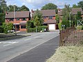
 Houses by the junction - geograph.org.uk - 847727.jpg 640 × 480 ; 64 kio
-
 Houses on Fenton House Lane, Wheaton Aston - geograph.org.uk - 6237327.jpg 800 × 600 ; 114 kio
-
 Houses on Roman Road near Lapley - geograph.org.uk - 6237642.jpg 800 × 600 ; 106 kio
-
 Houses on the A5 Watling Street - geograph.org.uk - 4901052.jpg 1 200 × 799 ; 381 kio
-
 Hurst Barn - geograph.org.uk - 2949521.jpg 1 142 × 857 ; 382 kio
-
 Ivory Cottage Indian Restaurant - geograph.org.uk - 4899124.jpg 1 200 × 799 ; 313 kio
-
 Ivy House Lane-A5 junction - geograph.org.uk - 2127833.jpg 640 × 480 ; 64 kio
-
 Ivy House on Watling Street (A5) - geograph.org.uk - 6158117.jpg 800 × 531 ; 71 kio
-
 Junction of Roman Road and Church Lane - geograph.org.uk - 4899245.jpg 1 200 × 799 ; 542 kio
-
 Just an ordinary muddy field - geograph.org.uk - 1746766.jpg 640 × 480 ; 265 kio
-
 Lane beside Longnor Hall Farm - geograph.org.uk - 1746714.jpg 640 × 480 ; 341 kio
-
 Lane north of Water Eaton - geograph.org.uk - 4473126.jpg 1 142 × 857 ; 470 kio
-
 Lane to Stretton - geograph.org.uk - 2127293.jpg 640 × 480 ; 84 kio
-
 Lane to Water Eaton - geograph.org.uk - 2601007.jpg 640 × 480 ; 193 kio
-
 Lane to Whiston - geograph.org.uk - 2600999.jpg 640 × 480 ; 74 kio
-
 Lane west of Lapley, Staffordshire - geograph.org.uk - 4688039.jpg 1 024 × 670 ; 344 kio
-
 Lapley - All Saints Church - geograph.org.uk - 5233248.jpg 5 184 × 2 920 ; 6,09 Mio
-
 Lapley Lane - geograph.org.uk - 6158114.jpg 800 × 600 ; 185 kio
-
 Lapley Lane towards Stretton - geograph.org.uk - 5746425.jpg 800 × 534 ; 143 kio
-
 Lapley Road - geograph.org.uk - 6237627.jpg 800 × 600 ; 163 kio
-
 Lapley Road near Wheaton Aston, Staffordshire - geograph.org.uk - 4685255.jpg 1 024 × 723 ; 487 kio
-
 Lapley Road towards Bickford - geograph.org.uk - 6237662.jpg 800 × 600 ; 131 kio
-
 Lapley Wood along the Shropshire Union Canal - geograph.org.uk - 5750403.jpg 800 × 663 ; 217 kio
-
 Lapley Wood Farmhouse - geograph.org.uk - 1746771.jpg 640 × 480 ; 320 kio
-
 Lay by east of Bell Field - geograph.org.uk - 3518906.jpg 640 × 383 ; 42 kio
-
 Long Street in Wheaton Aston, Staffordshire - geograph.org.uk - 4685024.jpg 1 024 × 693 ; 457 kio
-
 Long Street in Wheaton Aston, Staffordshire - geograph.org.uk - 4688594.jpg 1 024 × 675 ; 496 kio
-
 Long Street, Wheaton Aston - geograph.org.uk - 6237620.jpg 800 × 600 ; 73 kio
-
 Looking back towards Lapley Wood Farm - geograph.org.uk - 3974050.jpg 814 × 1 088 ; 338 kio
-

-
 Looking down The Staffordshire Way - geograph.org.uk - 2467276.jpg 640 × 428 ; 107 kio
-

-
 Makeshift gate to a paddock - geograph.org.uk - 2600996.jpg 640 × 480 ; 140 kio
-
 Marston Road towards Wheaton Aston - geograph.org.uk - 6237325.jpg 800 × 600 ; 138 kio
-
 Mileford Cottage near Lapley - geograph.org.uk - 6237632.jpg 800 × 600 ; 88 kio
-
 Milepost at Wheaton Aston - geograph.org.uk - 5751621.jpg 800 × 519 ; 158 kio
-
 Milepost at Wheaton Aston - geograph.org.uk - 5751633.jpg 800 × 724 ; 310 kio
-
 Milepost near Lapley Wood Bridge No 17 - geograph.org.uk - 5750410.jpg 800 × 589 ; 210 kio
-
 Minor road junction, Water Eaton - geograph.org.uk - 6158121.jpg 800 × 600 ; 91 kio
-
 Moored narrowboats at Stretton Wharf - geograph.org.uk - 4600350.jpg 640 × 427 ; 92 kio
-
 Mud on the road to Water Eaton - geograph.org.uk - 4910628.jpg 1 600 × 1 064 ; 696 kio
-
 Muddy Bridleway - geograph.org.uk - 1746700.jpg 640 × 480 ; 446 kio
-
 Muddy bridleway - geograph.org.uk - 3393155.jpg 857 × 1 142 ; 349 kio
-
 Muddy towpath towards Lapley Wood Bridge - geograph.org.uk - 3396035.jpg 979 × 734 ; 368 kio
-
 Narrow lane to Water Eaton - geograph.org.uk - 4473128.jpg 857 × 1 142 ; 440 kio
-
 Narrowboat on dry land near Stretton, Staffordshire - geograph.org.uk - 6019614.jpg 1 600 × 900 ; 1,63 Mio
-
 New build house on Bellhurst Lane - geograph.org.uk - 2949569.jpg 1 142 × 857 ; 321 kio
-
 New Buildings Farm on Ivetsey Road - geograph.org.uk - 4899112.jpg 1 200 × 799 ; 251 kio
-
 New Buildings Farm, Wheaton Aston - geograph.org.uk - 2589059.jpg 640 × 428 ; 58 kio
-

-
 Oh, 'eck...^ - geograph.org.uk - 3393143.jpg 832 × 1 110 ; 341 kio
-
 OS benchmark - Horsebrook, house at road junction - geograph.org.uk - 4475697.jpg 857 × 1 142 ; 559 kio
-
 OS benchmark - Horsebrook, The Ivy House - geograph.org.uk - 4473137.jpg 857 × 1 142 ; 454 kio
-
 OS benchmark - Lapley, Stonyford Bridge - geograph.org.uk - 4577161.jpg 857 × 1 142 ; 575 kio
-
 OS benchmark - Longnor Hall outbuilding - geograph.org.uk - 3976014.jpg 734 × 979 ; 442 kio
-
 OS benchmark - Longnor, Lapley Bank Cottages - geograph.org.uk - 5070408.jpg 1 224 × 1 632 ; 837 kio
-
 OS benchmark - Rowley Hill Cottages - geograph.org.uk - 4070479.jpg 857 × 1 142 ; 554 kio


_-_geograph.org.uk_-_6158077.jpg)


_-_geograph.org.uk_-_6158088.jpg)


_-_geograph.org.uk_-_6158091.jpg)
_-_geograph.org.uk_-_6158078.jpg)


_-_geograph.org.uk_-_6158105.jpg)


_-_geograph.org.uk_-_6158117.jpg)


