Category:Lazistan Sanjak
Salti al navigilo
Salti al serĉilo
antikva regno kaj administra unuo de la Otomana Imperio | |||||
| Alŝuti plurmedion | |||||
| Estas | |||||
|---|---|---|---|---|---|
| Loko |
| ||||
| Anstataŭigas | |||||
| Anstataŭiĝas per | |||||
 | |||||
Lazistan or Lazona or Lazeti or Chaneti was the Ottoman administrative name for the sanjak (under Trebizond Vilayet) comprising the Laz or Lazuri-speaking population on the southeastern shore of the Black Sea.
Subkategorioj
Ĉi tiu kategorio havas la 2 jenajn subkategoriojn, el 2 entute.
H
L
Dosieroj en kategorio “Lazistan Sanjak”
La jenaj 27 dosieroj estas en ĉi tiu kategorio, el 27 entute.
-
 Anville, Jean Baptiste Bourguignon. Turkey in Asia. 1794 (BD).jpg 1 196 × 708; 235 KB
-

-
 Armenian population map 1896 cropped Lazistan.jpg 417 × 400; 100 KB
-
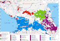 Caucasian Peoples and Languages as of 1990-2010.gif 2 869 × 1 991; 370 KB
-
 Colchis between the Black and Caspian Seas.jpg 1 112 × 815; 319 KB
-
 Guria Principality of Georgia, გურია.jpg 1 056 × 1 164; 1,03 MB
-
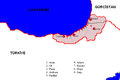
 Historical Lazona-Lazeti-Lazistan map.jpg 1 258 × 765; 1,05 MB
-

-
-

-

-

-

-
 Jouvet et Cie. Grece. Caucase et Crimee. 1882. (C).jpg 827 × 560; 179 KB
-
 Kingdom of Georgians ("Kingdom of Kartvels", Tao-Klarjeti), X c.jpg 1 882 × 2 379; 1,97 MB
-
 Kingdom of Georgians (Tao-Klarjeti), X c.jpg 1 882 × 2 379; 1,92 MB
-
 Lazistan Haritası - Map of Lazistan.tif 5 262 × 3 366, 2 paĝoj; 10,78 MB
-
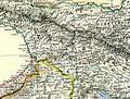
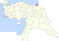
 Lazistan map.PNG 698 × 466; 19 KB
-
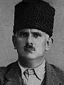
 Lazistan Mebusu Süleyman Sudi Bey.png 2 276 × 1 200; 1,41 MB
-
 Lazistan Mebusu İbrahim Ferid Efendi.png 2 276 × 1 200; 2,63 MB
-
 Lazistan.PNG 698 × 466; 16 KB
-
 Meskheti Map - მესხეთი - Saatabago Haritası.svg 653 × 447; 5,86 MB
-
 Meskheti Map - მესხეთის რუკა - სამცხე-საათაბაგო.jpg 4 352 × 2 979; 4,27 MB
-
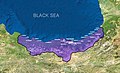
 Sanjak of Lazistan, Ottoman Anatolia, 1914.png 2 341 × 1 631; 622 KB
-
 Territorial claims of the Georgian SSR against Turkey, 1946.png 2 967 × 2 500; 842 KB
-
 W. & A.K. Johnston. Asia Minor. 1911 BO.jpg 297 × 267; 29 KB
-
 Zeynel Abidin Atak.jpg 179 × 238; 11 KB
.jpg)


.jpg)
,_X_c.jpg)
,_X_c.jpg)


._Turkey_in_Asia,_Transcaucasia._1861_(BCB).jpg)
._Turkey_in_Asia,_Transcaucasia._1861_(BDA).jpg)
._Turkey_in_Asia,_Transcaucasia._1861_(EA).jpg)
._Turkey_in_Asia,_Transcaucasia._1861_(EAA).jpg)
._Turkey_in_Asia,_Transcaucasia._1861_(EB).jpg)
._Turkey_in_Asia,_Transcaucasia._1861_(EBA).jpg)