Category:Le Chamossaire
Zur Navigation springen
Zur Suche springen
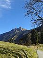
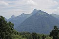
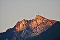
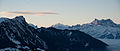
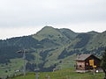
Français : Le Chamossaire est un sommet des Alpes bernoises dans le canton de Vaud en Suisse.
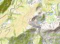
| Objektposition | | Karte mit allen Koordinaten: OpenStreetMap |
|---|
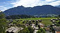
Berg in der Schweiz   | |||||
| Medium hochladen | |||||
| Ist ein(e) | |||||
|---|---|---|---|---|---|
| Ort |
| ||||
| Gebirgszug | |||||
| Schartenhöhe |
| ||||
| Höhe über dem Meeresspiegel |
| ||||
 | |||||
Unterkategorien
Es werden 2 von insgesamt 2 Unterkategorien in dieser Kategorie angezeigt:
In Klammern die Anzahl der enthaltenen Kategorien (K), Seiten (S), Dateien (D)
R
- Remote views of Le Chamossaire (19 D)
V
- Views from Le Chamossaire (48 D)
Medien in der Kategorie „Le Chamossaire“
Folgende 41 Dateien sind in dieser Kategorie, von 41 insgesamt.
-
 2020-01-18 2020 Winter Youth Olympics – Leysin (Martin Rulsch) 27.jpg 5.087 × 3.258; 6,52 MB
-
 Alpage near Javerne (14203924489).jpg 5.184 × 3.456; 9,74 MB
-
 CH-NB Photoglob-Wehrli EAD-WEHR-14501-B.tif 7.494 × 5.684, 2 Seiten; 81,31 MB
-
 Chamossaire A.jpg 1.920 × 2.560; 2,91 MB
-
 Chamossaire B.jpg 2.560 × 1.920; 3,53 MB
-
 Chamossaire C.jpg 1.920 × 2.560; 3,92 MB
-
 Col-de-Bretaye Le Chamossaire.jpg 4.000 × 3.000; 4,39 MB
-
 Crêta Besse - Le Chamossaire - La Motte - Sé Rouge.jpg 5.760 × 3.840; 6,1 MB
-
 Dent favre mars 2021.jpg 908 × 1.210; 309 KB
-

-
 Grand Chamossaire.JPG 3.072 × 2.304; 3,88 MB
-
 L03 423 Leysin, Le Chamossaire.jpg 6.855 × 4.570; 7,54 MB
-
 L03 452 Leysin, Le Chamossaire.jpg 6.529 × 4.353; 6,31 MB
-
 L03 468 Le Chamossaire.jpg 6.550 × 4.367; 6,99 MB
-
 L03 599 Troistorrents.jpg 6.531 × 4.354; 7,2 MB
-
 Le Chamossaire (44564314621).jpg 5.184 × 3.456; 5,26 MB
-
 Le Chamossaire (VD).jpg 5.568 × 3.712; 3,24 MB
-
 Le Chamossaire - Dents du Midi.jpg 6.048 × 2.566; 8,83 MB
-
 Le Chamossaire from La Barboleusaz.JPG 4.000 × 3.000; 5,72 MB
-
 Le Chamossaire OSM.png 826 × 608; 635 KB
-
 Le Chamossaire.jpg 6.024 × 4.016; 17,52 MB
-
 Le-Chamossair.JPG 2.720 × 2.040; 1,73 MB
-
 Les Diablerets (13149144403).jpg 5.184 × 3.456; 6,54 MB
-
 Leysin, Switzerland - panoramio.jpg 2.855 × 1.896; 3,39 MB
-
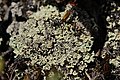 Lichen (30905536828).jpg 5.184 × 3.456; 5,82 MB
-
 Lichen (44776723851).jpg 5.184 × 3.456; 5,86 MB
-
 Noon in the Swiss nature.jpg 4.032 × 2.268; 3,92 MB
-
 Panoramic view near Leysin (14302301677).jpg 10.288 × 2.450; 24,74 MB
-
 Panoramic view near Leysin - panoramio.jpg 10.288 × 2.450; 23,79 MB
-
 Panoramic view near Plan de Mayen (15361918717).jpg 14.614 × 2.357; 38,14 MB
-
 Panoramic view near Plan de Mayen - panoramio (2).jpg 14.614 × 2.357; 9,86 MB
-
 Panoramic view near Plan de Mayen - panoramio (3).jpg 12.547 × 2.507; 7,08 MB
-
 Panoramic view near Plan de Mayen Panoramic view near Plan de Mayen (15361309549).jpg 12.547 × 2.507; 30,45 MB
-
 Panoramic view near the Tour d'Aï - panoramio (2).jpg 5.184 × 3.456; 6,57 MB
-
 Panoramic view near the Tour d'Aï - panoramio (5).jpg 12.155 × 2.505; 18,28 MB
-
 Pic Chaussy, Le Tarent and La Para (30884982018).jpg 5.184 × 3.456; 5,09 MB
-
 Salin-Le-Chamossaire-aerial.JPG 2.720 × 2.040; 1,77 MB
-
 Via Ferrata Plan Praz à Leysin, Vaud.jpg 4.032 × 3.024; 5,33 MB
-
 View on Le Chamossaire - panoramio (1).jpg 5.184 × 3.456; 7,52 MB
-
 View on Le Chamossaire - panoramio.jpg 5.184 × 3.456; 7,31 MB
-
 Villars-sur-Ollon telecabine E.jpg 2.685 × 3.906; 1,26 MB
_27.jpg)
.jpg)


.jpg)
.jpg)


.jpg)

.jpg)
.jpg)

.jpg)
.jpg)


.jpg)


.jpg)
.jpg)
.jpg)
.jpg)
.jpg)
.jpg)