Category:Lindon, Utah
Zur Navigation springen
Zur Suche springen
Stadt im US-Bundesstaat Utah   | |||||
| Medium hochladen | |||||
| Ist ein(e) | |||||
|---|---|---|---|---|---|
| Benannt nach |
| ||||
| Ort | Utah County, Utah | ||||
| Liegt am oder im Gewässer | |||||
| Datum der Gründung, Erstellung, Entstehung, Erbauung |
| ||||
| Einwohnerzahl |
| ||||
| Fläche |
| ||||
| Höhe über dem Meeresspiegel |
| ||||
| offizielle Website | |||||
 | |||||
English: Media related to Lindon, Utah, a city in north-central Utah County, Utah, Untied States.
Unterkategorien
Es werden 4 von insgesamt 4 Unterkategorien in dieser Kategorie angezeigt:
In Klammern die Anzahl der enthaltenen Kategorien (K), Seiten (S), Dateien (D)
Medien in der Kategorie „Lindon, Utah“
Folgende 31 Dateien sind in dieser Kategorie, von 31 insgesamt.
-

-
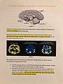 Addiction and how it effects the brain.jpg 1.512 × 2.016; 546 KB
-
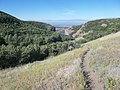 Dry Canyon Trail - panoramio (1).jpg 4.288 × 3.216; 2,67 MB
-
 Dry Canyon Trail - panoramio.jpg 4.288 × 3.216; 2,83 MB
-
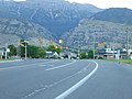
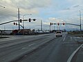
 East at I-15 & SR-241 interchange on Orem-Lindon line, Utah, Jun 16.jpg 2.592 × 1.944; 2,36 MB
-
 East at SR-241 & SR-114 junction in Utah County, Utah, Jun 16.jpg 2.592 × 1.944; 2,37 MB
-
 East at US-89 & SR-129, Pleasant Grove-Lindon border, Utah, Jun 16.jpg 2.592 × 1.944; 2,44 MB
-
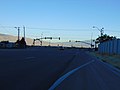
 East at western terminus SR-135, American Fork, Utah, Jan 17.jpg 2.592 × 1.944; 2,4 MB
-
 East on SR-135, Lindon, Utah, Jan 17.jpg 2.592 × 1.944; 2,35 MB
-
 Little Miss Lindon (28949381937).jpg 5.017 × 3.538; 4,82 MB
-
 Little Miss Lindon (42981718585).jpg 3.617 × 2.188; 2,47 MB
-
 Mount Timpanogos 995 px.jpg 995 × 163; 37 KB
-
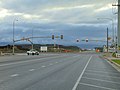
 North at SR-129 & SR-114 Junction, Lindon, Utah, Jun 16.jpg 2.592 × 1.944; 2,39 MB
-
 North at SR-241 & SR-114 junction in Utah County, Utah, Jun 16.jpg 2.592 × 1.944; 2,35 MB
-
 North at western terminus SR-135, American Fork, Utah, Jan 17.jpg 2.592 × 1.944; 2,42 MB
-
 Northwest at US-89 & SR-129, Pleasant Grove-Lindon border, Utah, Jun 16.jpg 2.592 × 1.944; 2,3 MB
-
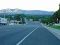 Northwest on N State St (US-89), Lindon, Utah, Jun 16.jpg 2.592 × 1.944; 2,39 MB
-
 South at SR-129 & SR-114 Junction, Lindon, Utah, Jun 16.jpg 2.592 × 1.944; 2,26 MB
-
 South at SR-241 & SR-114 junction in Utah County, Utah, Jun 16.jpg 2.592 × 1.944; 2,36 MB
-
 South at western terminus SR-135, American Fork, Utah, Jan 17.jpg 2.592 × 1.944; 2,36 MB
-
 Southeast at US-89 & SR-129, Pleasant Grove-Lindon border, Utah, Jun 16.jpg 2.592 × 1.944; 2,29 MB
-
 Southeast on US-89 in Lindon, Utah, Jun 16.jpg 2.592 × 1.944; 2,36 MB
-
 Southwest at Lake Side Power Station, Vineyard, Utah, Jun 16.jpg 2.592 × 1.944; 2,37 MB
-
 The Wasatch Front - wickenden.jpg 3.872 × 2.570; 9,76 MB
-
 Utah County Utah incorporated and unincorporated areas Lindon highlighted.svg 1.030 × 741; 2,6 MB
-
 Utah Lake from Dry Canyon Trail - panoramio.jpg 4.288 × 3.216; 2,61 MB
-
 UTMap-doton-Lindon.PNG 238 × 300; 18 KB
-
 West at SR-129 & SR-114 Junction, Lindon, Utah, Jun 16.jpg 2.592 × 1.944; 2,21 MB
-
 West at SR-241 & SR-114 junction in Utah County, Utah, Jun 16.jpg 2.592 × 1.944; 2,33 MB
-
 West at US-89 & SR-129, Pleasant Grove-Lindon border, Utah, Jun 16.jpg 2.592 × 1.944; 2,31 MB
-
 West at western terminus SR-135, Lindon, Utah.jpg 2.592 × 1.944; 2,31 MB


.jpg)


.jpg)
.jpg)


,_Lindon,_Utah,_Jun_16.jpg)


Kategorien:
- Cities in Utah
- Populated places in Utah County, Utah
- Populated places in Utah Valley
- Places named after plants
- Locations along Interstate 15 in Utah County, Utah
- Locations along U.S. Route 50 in Utah (1926-1953) in Utah County, Utah
- Locations along U.S. Route 50 Alternate in Utah County, Utah
- Locations along U.S. Route 89 in Utah County, Utah
- Locations along U.S. Route 91 in Utah (1926-1974) in Utah County, Utah
- Locations along Utah State Route 8 (1910-1977)
- Locations along Utah State Route 114
- Locations along Utah State Route 129
- Locations along Utah State Route 135
- Locations along Utah State Route 241