Category:Llangennith, Llanmadoc and Cheriton
Zur Navigation springen
Zur Suche springen
community in Swansea, Wales, UK  | |||||
| Medium hochladen | |||||
| Aussprache (Audiodatei) | |||||
|---|---|---|---|---|---|
| Ist ein(e) | |||||
| Ort | Swansea, Wales | ||||
| Einwohnerzahl |
| ||||
| Fläche |
| ||||
 | |||||
Unterkategorien
Es werden 5 von insgesamt 5 Unterkategorien in dieser Kategorie angezeigt:
In Klammern die Anzahl der enthaltenen Kategorien (K), Seiten (S), Dateien (D)
Medien in der Kategorie „Llangennith, Llanmadoc and Cheriton“
Folgende 200 Dateien sind in dieser Kategorie, von 530 insgesamt.
(vorherige Seite) (nächste Seite)-
 2010 Wales Swansea Community Llangennith, Llanmadoc and Cheriton map.svg 512 × 472; 632 KB
-
 2024 Wales Swansea Community Llangennith, Llanmadoc and Cheriton map.svg 512 × 472; 651 KB
-
 A bridleway behind Llanmadoc - geograph.org.uk - 2684638.jpg 1.142 × 857; 661 KB
-
 A Geograph challenge - geograph.org.uk - 6286178.jpg 2.286 × 3.048; 1,09 MB
-
 A line in the sand - geograph.org.uk - 6286107.jpg 1.536 × 2.048; 1,47 MB
-

-
 Abandoned Vessel at Landimore Marsh - geograph.org.uk - 2082352.jpg 1.936 × 2.592; 2,86 MB
-
 Across the ebbing tide - geograph.org.uk - 6286096.jpg 2.026 × 1.552; 729 KB
-
 Agricultural vehicle - geograph.org.uk - 5920398.jpg 3.264 × 2.448; 2,58 MB
-
 Along the beach north of Hill's Tor - geograph.org.uk - 2686699.jpg 1.306 × 979; 700 KB
-
 Along the dune edge at Whiteford Point - geograph.org.uk - 2686946.jpg 1.142 × 857; 596 KB
-
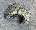 Aphrodite aculeata - a ‘sea mouse’ - geograph.org.uk - 6296061.jpg 1.926 × 1.632; 767 KB
-

-
 Approaching storm - geograph.org.uk - 6294701.jpg 3.150 × 2.363; 2,94 MB
-
 Approaching storm - geograph.org.uk - 6296636.jpg 3.105 × 2.326; 1,98 MB
-

-
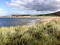
 Bae Broughton Bay - geograph.org.uk - 3183172.jpg 690 × 518; 118 KB
-
 Bae Broughton Bay - geograph.org.uk - 3846063.jpg 640 × 480; 60 KB
-
 Bae Rhossili Bay - geograph.org.uk - 3184607.jpg 690 × 518; 156 KB
-
 Bay Behind Whiteford Point - geograph.org.uk - 1417433.jpg 640 × 480; 87 KB
-
 Beach below Prissen's Tor - geograph.org.uk - 4909990.jpg 6.000 × 4.000; 7,75 MB
-
 Beach Between Burry Holms And Spaniard Rocks - geograph.org.uk - 4556959.jpg 2.560 × 1.920; 2,07 MB
-
 Beach near Cwm Ivy Tor - geograph.org.uk - 2969231.jpg 640 × 480; 50 KB
-
 Behind the dunes on Rhossili Bay - geograph.org.uk - 4907604.jpg 6.000 × 4.000; 4,68 MB
-
 Bellevue Farm - geograph.org.uk - 5852403.jpg 3.264 × 2.448; 2,32 MB
-
 Berges Island - geograph.org.uk - 6286097.jpg 3.182 × 2.388; 2,49 MB
-
 Bessie's Mead, at the north of Rhossili Down - geograph.org.uk - 5839970.jpg 1.600 × 1.200; 757 KB
-
 Bird hide - geograph.org.uk - 5852444.jpg 3.264 × 2.448; 2,91 MB
-
 Bivalves and mussels - geograph.org.uk - 6286164.jpg 3.195 × 2.396; 3,36 MB
-
 Bluepool Corner - geograph.org.uk - 873404.jpg 640 × 480; 144 KB
-
 Breached causeway - geograph.org.uk - 5852499.jpg 3.264 × 2.448; 3,04 MB
-
 Bridge to North Hill Tor - geograph.org.uk - 2082337.jpg 640 × 478; 307 KB
-

-
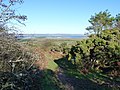
 Bridleway on Llanmadoc Hill - geograph.org.uk - 5156815.jpg 4.000 × 3.000; 2,05 MB
-
 Bridleway on Llanmadoc Hill - geograph.org.uk - 5156837.jpg 4.000 × 3.000; 2,02 MB
-
 Bridleway on Rhossili Down - geograph.org.uk - 4899432.jpg 6.000 × 4.000; 4,14 MB
-
 Broughton Bay - geograph.org.uk - 2078876.jpg 510 × 640; 239 KB
-
 Broughton Bay - geograph.org.uk - 2078902.jpg 640 × 478; 323 KB
-
 Broughton Bay - geograph.org.uk - 2078910.jpg 640 × 478; 311 KB
-
 Broughton Bay - geograph.org.uk - 2078915.jpg 478 × 640; 259 KB
-
 Broughton Bay - geograph.org.uk - 2078922.jpg 1.936 × 2.592; 2,91 MB
-
 Broughton Bay - geograph.org.uk - 4909951.jpg 6.000 × 4.000; 7 MB
-
 Broughton Bay - geograph.org.uk - 4909975.jpg 6.000 × 4.000; 6,84 MB
-
 Broughton Bay - geograph.org.uk - 5154861.jpg 4.000 × 3.000; 1,87 MB
-
 Broughton Bay - geograph.org.uk - 873412.jpg 640 × 398; 151 KB
-
 Broughton Bay - geograph.org.uk - 873423.jpg 640 × 480; 165 KB
-
 Broughton Bay and Sand Dunes - geograph.org.uk - 217020.jpg 640 × 480; 84 KB
-
 Broughton Bay beach - geograph.org.uk - 2686694.jpg 1.304 × 856; 450 KB
-
 Broughton Bay from Prissen's Tor - geograph.org.uk - 2079036.jpg 640 × 474; 291 KB
-
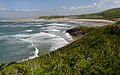
 Broughton Beach and Sea - geograph.org.uk - 3140232.jpg 1.200 × 800; 740 KB
-
 Broughton Burrows - geograph.org.uk - 4556984.jpg 2.560 × 1.920; 3,54 MB
-
 Broughton Burrows - geograph.org.uk - 4846026.jpg 1.600 × 1.067; 363 KB
-
 Broughton Burrows - geograph.org.uk - 4909929.jpg 6.000 × 4.000; 5,58 MB
-
 Broughton Burrows - geograph.org.uk - 5852398.jpg 3.264 × 2.448; 3,44 MB
-
 Broughton Farm from the coast path - geograph.org.uk - 4909957.jpg 6.000 × 4.000; 3,85 MB
-
 Bryn Llanmadoc Hill - geograph.org.uk - 3183119.jpg 690 × 518; 149 KB
-
 Bryn Llanmadoc Hill - geograph.org.uk - 3183136.jpg 690 × 518; 149 KB
-
 Bryn y Moe - geograph.org.uk - 5852407.jpg 3.264 × 2.448; 2,8 MB
-
 Bryngaer Burry Holms Hillfort - geograph.org.uk - 3184626.jpg 690 × 518; 167 KB
-
 Bryngaer Hardings Down Hillfort - geograph.org.uk - 4252679.jpg 640 × 480; 77 KB
-
 Building remains high on Rhossili Down - geograph.org.uk - 4005310.jpg 4.000 × 3.000; 3,14 MB
-
 Burrows Cottage - geograph.org.uk - 5852435.jpg 3.264 × 2.448; 3,32 MB
-
 Burry Court - geograph.org.uk - 1313200.jpg 640 × 480; 62 KB
-
 Burry Green - geograph.org.uk - 3437123.jpg 1.853 × 1.310; 1,07 MB
-

-
 Burry Green, Gower Peninsula - geograph.org.uk - 1313201.jpg 640 × 480; 62 KB
-
 Burry Holms - geograph.org.uk - 4556951.jpg 2.560 × 1.920; 3,35 MB
-
 Burry Holms - geograph.org.uk - 4908731.jpg 6.000 × 4.000; 6 MB
-
 Burry Holms - geograph.org.uk - 4908768.jpg 6.000 × 4.000; 4,07 MB
-
 Burry Holms - geograph.org.uk - 4908778.jpg 6.000 × 4.000; 4,93 MB
-
 Burry Holms - geograph.org.uk - 4994820.jpg 3.456 × 2.304; 1,98 MB
-
 Burry Holms - geograph.org.uk - 5155676.jpg 3.901 × 2.925; 1,51 MB
-
 Burry Holms - geograph.org.uk - 6294684.jpg 3.020 × 2.056; 1,19 MB
-
 Burry Pil - geograph.org.uk - 1324030.jpg 640 × 480; 57 KB
-
 Burry Pill - geograph.org.uk - 6285667.jpg 2.048 × 1.536; 1,36 MB
-
 Burry Pill - geograph.org.uk - 977163.jpg 640 × 480; 76 KB
-
 Bury Holmes - geograph.org.uk - 4845827.jpg 3.957 × 2.631; 971 KB
-
 Bus shelter at Burry Green - geograph.org.uk - 3437104.jpg 1.785 × 1.249; 1,03 MB
-
 Buttercups at Burry Green - geograph.org.uk - 1313488.jpg 640 × 480; 94 KB
-
 Cairn I on the western end of Llanmadoc Hill - geograph.org.uk - 2692197.jpg 1.306 × 979; 361 KB
-
 Cairn on Llanmadoc Hill - geograph.org.uk - 4905957.jpg 6.000 × 4.000; 5,68 MB
-
 Cairn XII on Llanmadoc Hill - geograph.org.uk - 2691204.jpg 1.306 × 979; 338 KB
-

-
 Caravan site, Hillend Burrows - geograph.org.uk - 5839977.jpg 1.600 × 1.200; 788 KB
-
 Causeway across Cwm Ivy at The Groose - geograph.org.uk - 5852458.jpg 2.448 × 3.264; 4,09 MB
-
 Cheriton Church - geograph.org.uk - 4858137.jpg 640 × 428; 101 KB
-
 Clifftop above Bluepool Corner - geograph.org.uk - 4909923.jpg 6.000 × 4.000; 5,55 MB
-
 Climb up Hills Tor - geograph.org.uk - 2079065.jpg 478 × 640; 306 KB
-
 Coast path above Bluepool Corner - geograph.org.uk - 4909938.jpg 6.000 × 4.000; 5,48 MB
-
 Coast path by Broughton Burrows - geograph.org.uk - 4909945.jpg 6.000 × 4.000; 6 MB
-
 Coastal Footpath at Landimore - geograph.org.uk - 2082359.jpg 1.936 × 2.592; 3,52 MB
-
 Coastal panorama - geograph.org.uk - 6294733.jpg 6.360 × 2.929; 3,94 MB
-

-
 Cockstreet - geograph.org.uk - 1490544.jpg 640 × 427; 93 KB
-
 Cockstreet - geograph.org.uk - 1490546.jpg 640 × 427; 107 KB
-
 Coed Cwm Ivy Woods - geograph.org.uk - 3843336.jpg 640 × 480; 140 KB
-
 Conifer woodland - geograph.org.uk - 1069635.jpg 640 × 480; 141 KB
-
 Conifers on the dunes - geograph.org.uk - 5154831.jpg 4.000 × 3.000; 3,11 MB
-
 Cottage at Delvid Farm - geograph.org.uk - 2685020.jpg 979 × 734; 423 KB
-
 Cottages in Cwm Ivy - geograph.org.uk - 4910080.jpg 6.000 × 4.000; 4,22 MB
-
 Cottages Llangennith - geograph.org.uk - 3274567.jpg 1.024 × 765; 148 KB
-
 Cottages, Rhossili Down - geograph.org.uk - 1490257.jpg 640 × 466; 99 KB
-
 Cwm Ivy - geograph.org.uk - 2682569.jpg 1.142 × 857; 573 KB
-
 Cwm Ivy - geograph.org.uk - 3183152.jpg 690 × 518; 146 KB
-
 Cwm Ivy - geograph.org.uk - 6286098.jpg 3.264 × 2.448; 2,55 MB
-
 Cwm Ivy Marsh - geograph.org.uk - 2630165.jpg 3.547 × 2.660; 1,55 MB
-
 Cwm Ivy Marsh - geograph.org.uk - 2630179.jpg 3.547 × 2.660; 2,62 MB
-
 Cwm Ivy marsh - geograph.org.uk - 5154815.jpg 4.000 × 3.000; 2,44 MB
-
 Cwm Ivy Marsh Sea Wall - geograph.org.uk - 4562507.jpg 640 × 428; 109 KB
-
 Cwm Ivy Marsh Sea Wall Breach (geograph 4562517).jpg 640 × 428; 102 KB
-
 Cwm Ivy Marsh Sea Wall Breach - geograph.org.uk - 4562525.jpg 640 × 428; 105 KB
-
 Cwm Ivy Tor - geograph.org.uk - 3183161.jpg 690 × 518; 178 KB
-
 Cwm Ivy Tor - geograph.org.uk - 5852430.jpg 3.264 × 2.448; 3,8 MB
-
 Diles Lake - geograph.org.uk - 4845768.jpg 2.812 × 2.153; 1,11 MB
-
 Diles Lake - geograph.org.uk - 6294677.jpg 3.264 × 2.448; 2,29 MB
-
 Duck pond outside holiday cottage - geograph.org.uk - 1537930.jpg 640 × 480; 71 KB
-
 Dunes (and Shell Mounds) in Whiteford Burrows - geograph.org.uk - 2686979.jpg 1.142 × 857; 644 KB
-
 Dunes at the southern end of Whiteford Burrows - geograph.org.uk - 5154840.jpg 4.000 × 3.000; 2,55 MB
-
 Dunes at Whiteford Burrows - geograph.org.uk - 2969052.jpg 640 × 480; 49 KB
-
 Dunes below Cwm Ivy Tor - geograph.org.uk - 4910029.jpg 6.000 × 4.000; 6,97 MB
-
 Dunes in the Whiteford NNR - geograph.org.uk - 2686987.jpg 1.142 × 857; 599 KB
-
 Dunes south of Whiteford Burrows - geograph.org.uk - 2682556.jpg 979 × 734; 406 KB
-
 East Cwm Ivy - geograph.org.uk - 6286099.jpg 2.048 × 1.536; 985 KB
-
 Edge of the sands, Broughton Bay - geograph.org.uk - 5154877.jpg 3.909 × 2.933; 1,58 MB
-
 Entrance of Hillend caravan site and car park - geograph.org.uk - 5839982.jpg 1.600 × 1.200; 721 KB
-

-
 Evening sunlight on Hill's Tor - geograph.org.uk - 2685587.jpg 1.306 × 979; 686 KB
-
 Evening time beneath North Hill Tor - geograph.org.uk - 2685619.jpg 1.142 × 857; 592 KB
-
 Farm buildings at Broughton Farm - geograph.org.uk - 4909968.jpg 6.000 × 4.000; 5,08 MB
-
 Farm north of Llangennith - geograph.org.uk - 1490516.jpg 640 × 426; 114 KB
-
 Farmland near Llanmadoc - geograph.org.uk - 2450891.jpg 640 × 480; 66 KB
-
 Fence line meandering through the dunes - geograph.org.uk - 4907606.jpg 6.000 × 4.000; 5,7 MB
-
 Ffarm Kittlehill Farm - geograph.org.uk - 3847177.jpg 640 × 480; 111 KB
-
 Fields North of Broughton Bay - geograph.org.uk - 2079099.jpg 640 × 478; 277 KB
-
 Flooded Farmland Cwm Ivy Marsh (geograph 4858523).jpg 640 × 428; 126 KB
-
 Flooded forest and peat on Broughton beach - geograph.org.uk - 2687630.jpg 1.142 × 857; 462 KB
-
 Flotsam and jetsam on Whiteford Sands - geograph.org.uk - 4910012.jpg 6.000 × 4.000; 3,61 MB
-
 Footbridge near College Mill - geograph.org.uk - 1490355.jpg 640 × 422; 161 KB
-
 Footbridge near North Hill Tor - geograph.org.uk - 4858905.jpg 640 × 428; 92 KB
-
 Footbridge over stream - geograph.org.uk - 5920405.jpg 3.015 × 2.263; 2,22 MB
-

-
 Footpath below Llanmadoc Hill - geograph.org.uk - 2685016.jpg 979 × 734; 467 KB
-
 Footpath NW Of Sluxton Farm - geograph.org.uk - 4557062.jpg 2.560 × 1.920; 3,01 MB
-

-
 Footpath onto Llanmadoc Hill - geograph.org.uk - 2447372.jpg 640 × 480; 117 KB
-
 Footpath or stream - geograph.org.uk - 5921701.jpg 2.448 × 3.264; 3,27 MB
-
 Footpaths below Kittlehill - geograph.org.uk - 2538034.jpg 640 × 480; 146 KB
-
 Foundations of a WW2 building on Rhossili Down - geograph.org.uk - 5838866.jpg 1.600 × 1.200; 726 KB
-
 Foundations of former chapel on Burry Holms - geograph.org.uk - 5479241.jpg 4.000 × 3.000; 3,82 MB
-
 Foundations of WW2 Rhossili Down radar station - geograph.org.uk - 5838871.jpg 1.600 × 1.200; 762 KB
-
 Foxhole Point, Broughton Bay - geograph.org.uk - 2078881.jpg 478 × 640; 238 KB
-
 Foxhole Point, Broughton Bay - geograph.org.uk - 2078898.jpg 640 × 478; 236 KB
-
 Friendship - geograph.org.uk - 2969209.jpg 640 × 480; 24 KB
-
 Frog Lane, Llanmadoc, 1985 - geograph.org.uk - 5477702.jpg 640 × 457; 53 KB
-
-
 Gate onto hillside - geograph.org.uk - 2538036.jpg 640 × 480; 90 KB
-
 Gate or Stile - geograph.org.uk - 2630147.jpg 3.547 × 2.660; 1,7 MB
-
 Gate to Landimore - geograph.org.uk - 5852566.jpg 3.264 × 2.448; 2,75 MB
-
 Gateway and Footpath, Llangennith - geograph.org.uk - 1490303.jpg 640 × 425; 139 KB
-
 Gateway into field - geograph.org.uk - 5921697.jpg 3.264 × 2.448; 1,52 MB
-

-
 Ger - Near Kennexstone - geograph.org.uk - 4214421.jpg 640 × 480; 57 KB
-
 Goleudy Whiteford - Whiteford Lighthouse - geograph.org.uk - 5850902.jpg 1.024 × 768; 217 KB
-
 Gorse and heather - geograph.org.uk - 5922249.jpg 2.815 × 2.003; 2,66 MB
-
 Gower Clay Pigeon Shooting - geograph.org.uk - 5852432.jpg 3.264 × 2.448; 2,71 MB
-
 Grassy track on Rhossili Down - geograph.org.uk - 5838864.jpg 1.600 × 1.200; 776 KB
-
 Grazing fields around Hardings Down - geograph.org.uk - 4520572.jpg 800 × 600; 156 KB
-
 Great Pill, Landimor - geograph.org.uk - 4261821.jpg 640 × 480; 44 KB
-

-
 Hambury Wood - geograph.org.uk - 5852582.jpg 3.264 × 2.448; 2,46 MB
-
 Hardings Down - geograph.org.uk - 1069634.jpg 640 × 480; 114 KB
-
 Hardings Down - geograph.org.uk - 4557039.jpg 2.560 × 1.920; 2,92 MB
-
 Hay Field Llanmadoc - geograph.org.uk - 4559401.jpg 640 × 428; 115 KB
-

-

-
 High on Rhossili Down - geograph.org.uk - 2693938.jpg 1.142 × 857; 638 KB
-
 Hill End Campsite, Llangennith - geograph.org.uk - 1397343.jpg 640 × 480; 42 KB
-

-
 Hillend Burrows, Llangennith - geograph.org.uk - 4845987.jpg 4.010 × 3.072; 2,52 MB
-
 Hillend campsite and Rhossili Down - geograph.org.uk - 2053433.jpg 3.072 × 1.932; 2,02 MB
-

-
 Hillend caravans - geograph.org.uk - 4005316.jpg 4.000 × 3.000; 3,36 MB
-
 Hillend Cottage - geograph.org.uk - 5922130.jpg 3.264 × 2.448; 2,21 MB
-
 Hillend from Rhossili Down - geograph.org.uk - 2053411.jpg 2.992 × 1.786; 1,87 MB
-
 Hills Tor - geograph.org.uk - 5852418.jpg 3.264 × 2.448; 1,89 MB
-
 Hills Tor - geograph.org.uk - 5852427.jpg 3.264 × 2.448; 4,02 MB
-
 Hillside above Llangennith - geograph.org.uk - 4906056.jpg 6.000 × 4.000; 6,79 MB
-
 Holiday cottage Tankeylake farm - geograph.org.uk - 1537925.jpg 640 × 480; 63 KB
-
 Horses at Landimore Marsh - geograph.org.uk - 2082306.jpg 640 × 353; 52 KB
-
 Horses grazing - geograph.org.uk - 5920400.jpg 2.872 × 2.215; 1,19 MB
-
 House at Landimore above the marsh - geograph.org.uk - 2537961.jpg 640 × 480; 96 KB
-
 Icecream van at Kennextone camp site - geograph.org.uk - 3854445.jpg 1.600 × 1.200; 349 KB
-
 If the devil could cast his net ... - geograph.org.uk - 6286101.jpg 3.264 × 2.448; 2,92 MB
-
 In Whiteford Burrows - geograph.org.uk - 1417328.jpg 640 × 480; 125 KB
-
 Incoming tide - geograph.org.uk - 6294725.jpg 3.029 × 2.271; 1,61 MB
-
 Industrial architecture - geograph.org.uk - 6286248.jpg 2.048 × 1.536; 654 KB
-
 Jellyfish stranded on Rhossili Beach - geograph.org.uk - 2760851.jpg 1.024 × 768; 364 KB
-
 Kissing Gate - geograph.org.uk - 5852526.jpg 2.379 × 3.175; 2,48 MB
-
 Kissing gate and footpath - geograph.org.uk - 5852449.jpg 3.264 × 2.448; 2,63 MB
-
 Kittlehill - geograph.org.uk - 873504.jpg 640 × 480; 251 KB


.jpg)


_in_Whiteford_Burrows_-_geograph.org.uk_-_2686979.jpg)


.jpg)


