Category:Llangunnor
Vai alla navigazione
Vai alla ricerca
village and community in Carmarthenshire, Wales, UK  | |||||
| Carica un file multimediale | |||||
| Istanza di | |||||
|---|---|---|---|---|---|
| Luogo | Carmarthenshire, Galles | ||||
| Popolazione |
| ||||
| Superficie |
| ||||
 | |||||
Cymraeg: Pentref a chymuned yn Sir Gaerfyrddin yw Llangynnwr, hefyd Llangunnor. Saif y pentref fymryn i'r dwyrain o dref Caerfyrddin, ger glan ddeheuol Afon Tywi. Cysegrwyd yr eglwys, yn dyddio o'r 14eg ganrif, i Sant Ceinwr. Mae David Charles yr emynydd a Lewis Morris y bardd Eingl-Gymreig wedi eu claddu yn y fynwent.
Sottocategorie
Questa categoria contiene le 3 sottocategorie indicate di seguito, su un totale di 3.
File nella categoria "Llangunnor"
Questa categoria contiene 197 file, indicati di seguito, su un totale di 197.
-
 3A's Leisure, Carmarthen - geograph.org.uk - 2526259.jpg 640 × 447; 78 KB
-
 A re-purposed bread oven - geograph.org.uk - 5433003.jpg 1 102 × 1 469; 918 KB
-
 A train for Manchester at Carmarthen - geograph.org.uk - 6218935.jpg 1 024 × 768; 370 KB
-

-
 A.Dean shop, Bridge Wharf, Carmarthen - geograph.org.uk - 6211565.jpg 1 600 × 1 081; 276 KB
-
 A40 westbound - geograph.org.uk - 6285247.jpg 640 × 478; 44 KB
-
 A40, Carmarthen bypass - geograph.org.uk - 3708803.jpg 640 × 430; 44 KB
-
 A40, Carmarthen bypass - geograph.org.uk - 3708804.jpg 640 × 430; 44 KB
-

-
 A48 at Carmarthen boundary sign - geograph.org.uk - 2935924.jpg 640 × 480; 52 KB
-

-
 A48 north of Cwmffrwd - geograph.org.uk - 2935920.jpg 640 × 480; 54 KB
-
 A48 Road Junction - geograph.org.uk - 2117830.jpg 640 × 480; 66 KB
-
 A48 west of Beaulieu-fawr - geograph.org.uk - 2935908.jpg 640 × 480; 46 KB
-
 A48 Westbound - geograph.org.uk - 4535367.jpg 1 600 × 949; 260 KB
-
 A48 westbound near Gelli-uchaf - geograph.org.uk - 2935885.jpg 640 × 481; 40 KB
-
 A48, eastbound - geograph.org.uk - 3708813.jpg 640 × 430; 53 KB
-
 A48, eastbound - geograph.org.uk - 3708822.jpg 640 × 430; 39 KB
-
 A48, eastbound - geograph.org.uk - 3708826.jpg 640 × 396; 35 KB
-

-

-
 Across Pont King Morgan, Carmarthen - geograph.org.uk - 4619046.jpg 695 × 800; 108 KB
-
 Across the River Towy, Carmarthen - geograph.org.uk - 4617236.jpg 800 × 537; 116 KB
-
 Afon Tywi - geograph.org.uk - 3820366.jpg 3 264 × 2 448; 3,12 MB
-
 Afon Tywi-River Towy - geograph.org.uk - 2829731.jpg 2 083 × 1 700; 1,39 MB
-
 Anhedd-dy ar y B4300 - A property on the B4300 - geograph.org.uk - 5903498.jpg 1 024 × 768; 174 KB
-
 Artistic cattle on Llangunnor Hill - geograph.org.uk - 1336582.jpg 640 × 480; 80 KB
-
 Beaulieu Plantation Lane - geograph.org.uk - 1291085.jpg 592 × 640; 186 KB
-
 Beiciau Hobbs Bikes - geograph.org.uk - 3361236.jpg 2 606 × 1 713; 730 KB
-

-
 Brandon Tool Hire - geograph.org.uk - 2183450.jpg 2 048 × 1 536; 640 KB
-
 Bridge over Afon Tywi - geograph.org.uk - 3361252.jpg 3 165 × 2 145; 930 KB
-
 Bridge over the Nant Cwmffrwd - geograph.org.uk - 5432999.jpg 1 306 × 979; 779 KB
-

-
 Bwlchymynydd road junction - geograph.org.uk - 5433006.jpg 1 469 × 1 102; 555 KB
-
 Capel Dewi road - geograph.org.uk - 2827380.jpg 2 560 × 1 920; 1,67 MB
-
 Cardigan bus, Station Approach, Carmarthen - geograph.org.uk - 6211586.jpg 1 600 × 1 248; 421 KB
-
 Carmarthen , River Towy - geograph.org.uk - 3927161.jpg 4 288 × 2 848; 5,45 MB
-
 Carmarthen flood alleviation defences - geograph.org.uk - 3056940.jpg 2 448 × 3 264; 1,22 MB
-

-
 Carmarthen railway station taxi rank - geograph.org.uk - 6149746.jpg 953 × 1 024; 168 KB
-
 Carmarthen railway station, Carmarthenshire - geograph.org.uk - 3992428.jpg 1 024 × 768; 206 KB
-
-
 Carmarthen Station, southwest view - geograph.org.uk - 5634781.jpg 3 916 × 2 820; 2,78 MB
-
 Carmarthenshire , The A48 - geograph.org.uk - 3927172.jpg 4 288 × 2 848; 6,47 MB
-
 Carmarthenshire , The A48 - geograph.org.uk - 3927175.jpg 4 288 × 2 848; 5,73 MB
-
 Chris Cars office, Carmarthen - geograph.org.uk - 4618999.jpg 800 × 540; 104 KB
-
 Class 175 dmu in Carmarthen station - geograph.org.uk - 6211511.jpg 1 600 × 968; 372 KB
-

-
 Cyffordd o draciau - A junction of tracks - geograph.org.uk - 5903546.jpg 1 024 × 768; 379 KB
-

-

-
 Disused road bridge over Nant Pibwr - geograph.org.uk - 1986366.jpg 1 024 × 768; 171 KB
-
 Dyffryn Tywi - The Tywi Valley - geograph.org.uk - 6285037.jpg 1 024 × 768; 145 KB
-
 East side of Pont Lesneven, Carmarthen - geograph.org.uk - 4619196.jpg 800 × 654; 185 KB
-
 End of the present day rail track - geograph.org.uk - 3321637.jpg 3 264 × 2 448; 1,58 MB
-
 Entrance to Carmarthen railway station - geograph.org.uk - 6149783.jpg 1 024 × 1 014; 215 KB
-

-
 Field - geograph.org.uk - 148432.jpg 480 × 640; 384 KB
-

-
 Grubs up^ in Carmarthen - geograph.org.uk - 6149712.jpg 1 024 × 894; 225 KB
-
 Heading east from Bwlchymynydd - geograph.org.uk - 5433010.jpg 1 469 × 1 102; 541 KB
-

-
 Heol las ger Tyhir - Green road near Tyhir - geograph.org.uk - 5903536.jpg 1 024 × 768; 232 KB
-
 Hobbs bicycle shop on cycle route 47 - geograph.org.uk - 3361227.jpg 1 927 × 1 209; 337 KB
-
 Howards Peugeot, Carmarthen - geograph.org.uk - 4617514.jpg 800 × 466; 97 KB
-

-

-

-
 J.H.Morse and MFI, Carmarthen - geograph.org.uk - 2984589.jpg 640 × 443; 62 KB
-
 Junction of Gwili and Tywi (Towy) rivers - geograph.org.uk - 2824268.jpg 1 668 × 928; 615 KB
-
 K6 phonebox on Carmarthen railway station - geograph.org.uk - 6178024.jpg 1 600 × 1 427; 446 KB
-
 Lane south of Ty-newydd - geograph.org.uk - 5433004.jpg 1 469 × 1 102; 690 KB
-
 Lane with bridge over the Nant Cwmffrwd - geograph.org.uk - 1249089.jpg 640 × 425; 135 KB
-

-
 Lay by on A48 near Cilwaunydd - geograph.org.uk - 3125243.jpg 640 × 422; 50 KB
-
 Lay-by on the A48 near Cwmffrwd - geograph.org.uk - 2560072.jpg 640 × 480; 53 KB
-

-

-

-
 Llangunnor Parish Church this way.jpg 900 × 675; 129 KB
-
 Llwybr Bolahaul - Bolahaul Path - geograph.org.uk - 6285997.jpg 1 024 × 768; 364 KB
-
 Llwybr Ffarm y Nant - Nant Farm Path - geograph.org.uk - 6285923.jpg 1 024 × 768; 208 KB
-
 Llwybr ger Ffarm y Nant - Path near Nant Farm - geograph.org.uk - 6285913.jpg 1 024 × 705; 253 KB
-
 Llwybr ger Heol Login - Path near Heol Login - geograph.org.uk - 6285951.jpg 1 024 × 768; 285 KB
-
-
 Llwybr ger Ty-cerrig - Path near Ty-cerrig - geograph.org.uk - 5903456.jpg 1 024 × 768; 380 KB
-
 Llwybr i Bibwrlwyd - Path to Pibwrlwyd - geograph.org.uk - 6286017.jpg 1 024 × 768; 248 KB
-

-
 Llwybr i Heol Login - Path to Login Road - geograph.org.uk - 6285979.jpg 1 024 × 705; 208 KB
-
 Llwybr Tygwyn - Tygwyn Path - geograph.org.uk - 6286046.jpg 1 024 × 767; 260 KB
-

-
 Maes Glasnant - geograph.org.uk - 1294312.jpg 640 × 480; 133 KB
-
 Manchester train in Carmarthen station - geograph.org.uk - 6149716.jpg 1 024 × 806; 201 KB
-
 Milepost, Carmarthen railway station - geograph.org.uk - 2983949.jpg 640 × 419; 86 KB
-
 Milestone - Carmarthen 1 - geograph.org.uk - 4331861.jpg 480 × 640; 129 KB
-
 Milestone - Carmarthen 1, Swansea 26 - geograph.org.uk - 4331923.jpg 480 × 640; 119 KB
-
 Milestone - Carmarthen 2 - geograph.org.uk - 4331915.jpg 480 × 640; 122 KB
-
 Milestone - Carmarthen 3 - geograph.org.uk - 4331866.jpg 480 × 640; 128 KB
-

-
 Minor road junction on A48 eastbound - geograph.org.uk - 3125251.jpg 640 × 437; 66 KB
-
 Morrisons Carmarthen - geograph.org.uk - 6285331.jpg 640 × 480; 48 KB
-
 Morrisons, supermarket car park - geograph.org.uk - 6285333.jpg 640 × 480; 67 KB
-
 Myrddin Garden Machinery, Carmarthen - geograph.org.uk - 4383589.jpg 800 × 481; 69 KB
-
 Nant Pipwr - geograph.org.uk - 5903467.jpg 1 024 × 768; 381 KB
-
 NE end of Carmarthen railway station - geograph.org.uk - 4617498.jpg 800 × 548; 105 KB
-
 New foot bridge into Carmarthen - geograph.org.uk - 3177347.jpg 2 480 × 1 269; 440 KB
-
 New foot bridge over Afon Towy - geograph.org.uk - 3177316.jpg 3 116 × 1 487; 615 KB
-
 New pedestrian bridge - geograph.org.uk - 3007518.jpg 2 484 × 1 046; 361 KB
-
 New pedestrian bridge - geograph.org.uk - 3007554.jpg 2 115 × 1 266; 261 KB
-
 No Through Road Sign - geograph.org.uk - 2695780.jpg 3 456 × 2 592; 3,36 MB
-

-
 Old building fenced from access - geograph.org.uk - 3321649.jpg 2 614 × 1 989; 898 KB
-
 Old cottage at Llangunnor (1).jpg 900 × 675; 167 KB
-
 Old cottage at Llangunnor (2).jpg 900 × 600; 130 KB
-
 Old Llangunner Road - geograph.org.uk - 3361300.jpg 2 261 × 1 425; 444 KB
-

-

-

-

-
 Ordnance Survey Benchmark and Rivet , Carmarthen Bridge - geograph.org.uk - 3693957.jpg 1 600 × 1 200; 530 KB
-
 Ordnance Survey Benchmark and Rivet , Carmarthen Bridge - geograph.org.uk - 3693962.jpg 1 600 × 1 200; 635 KB
-
 Ordnance Survey Cut Mark - geograph.org.uk - 3825022.jpg 640 × 480; 94 KB
-
 Ordnance Survey Rivet - geograph.org.uk - 3825035.jpg 480 × 640; 73 KB
-
 Ordnance Survey Rivet - geograph.org.uk - 4331858.jpg 480 × 640; 75 KB
-
 Overbridge, A48 - geograph.org.uk - 3708929.jpg 640 × 430; 46 KB
-
 Overgrown former platform, Carmarthen railway station - geograph.org.uk - 6211383.jpg 1 600 × 1 200; 422 KB
-

-
 Pembroke Dock train in Carmarthen station - geograph.org.uk - 6149728.jpg 1 024 × 822; 205 KB
-
 Platform 2, Carmarthen railway station - geograph.org.uk - 6211422.jpg 1 600 × 1 050; 392 KB
-
 Pompren ddifrodedig - Damaged footbridge - geograph.org.uk - 6286051.jpg 1 024 × 705; 324 KB
-
 Pont King Morgan, Carmarthen - geograph.org.uk - 2597243.jpg 1 280 × 963; 531 KB
-
 Pont Lesneven, Carmarthen - geograph.org.uk - 2984601.jpg 640 × 403; 78 KB
-
 Pownd Bolahaul - Bolahaul Pond - geograph.org.uk - 6286025.jpg 1 024 × 768; 206 KB
-
 Prepared For Bovine TB Testing - geograph.org.uk - 3310593.jpg 1 600 × 1 200; 677 KB
-
 Railway beyond Carmarthen station - geograph.org.uk - 6211373.jpg 1 600 × 1 594; 460 KB
-
 Railway bridge stone abutment - geograph.org.uk - 3321615.jpg 3 264 × 2 448; 1,06 MB
-
 Railway water tank - geograph.org.uk - 3321667.jpg 3 264 × 2 448; 3,86 MB
-

-
 Remnant of Steam trains - geograph.org.uk - 3007583.jpg 2 448 × 3 264; 1,09 MB
-
 Remnant of Steam Trains 2 - geograph.org.uk - 3810509.jpg 3 264 × 2 448; 3,76 MB
-
 Remnant of Steam Trains Gone^^^^ - geograph.org.uk - 3810521.jpg 3 264 × 2 448; 3,91 MB
-
 River slipway, Carmarthen - geograph.org.uk - 2984297.jpg 640 × 446; 66 KB
-

-
 River Towy, Carmarthen - geograph.org.uk - 4338481.jpg 1 600 × 1 062; 442 KB
-
 Road junction at Nantycaws - geograph.org.uk - 3125255.jpg 640 × 418; 44 KB
-
 Road near Ty-newydd - geograph.org.uk - 4147483.jpg 3 264 × 2 448; 2,93 MB
-
 Road West - geograph.org.uk - 4535452.jpg 1 600 × 1 063; 337 KB
-
 Roundabout sign near Pibwrlwyd - geograph.org.uk - 3584256.jpg 640 × 460; 37 KB
-
 Roundabout with dragon sculpture, Carmarthen - geograph.org.uk - 1819214.jpg 2 048 × 1 536; 1,38 MB
-
 Rural buildings, looking up the Loughor valley - geograph.org.uk - 6222165.jpg 1 600 × 960; 346 KB
-
 Sculpture on Pensarn traffic island - geograph.org.uk - 2984070.jpg 3 264 × 2 448; 3,19 MB
-
 Sculpture on traffic island - geograph.org.uk - 2984098.jpg 3 264 × 2 448; 2,95 MB
-

-
 Signal box, Carmarthen Junction - geograph.org.uk - 5511699.jpg 1 024 × 819; 179 KB
-
 Sir richard steel house.png 951 × 849; 1,16 MB
-
 Sir Richard Steele's House at Llangunnor (1133845).jpg 1 000 × 888; 275 KB
-
 Sir Richard Steele's House at Llangunnor.jpeg 900 × 827; 532 KB
-
 Solar powered street light - geograph.org.uk - 3361278.jpg 2 448 × 3 264; 1,01 MB
-
 Something fishy in Carmarthen - geograph.org.uk - 2984354.jpg 640 × 446; 76 KB
-
 South bank of the Towy, Carmarthen - geograph.org.uk - 2655235.jpg 640 × 472; 71 KB
-
 Southern outskirts of Carmarthen - geograph.org.uk - 3618888.jpg 3 131 × 2 184; 1,25 MB
-

-
 Station Approach Carmarthen - geograph.org.uk - 5251026.jpg 640 × 480; 160 KB
-
 Station Approach side of Carmarthen railway station - geograph.org.uk - 6211301.jpg 1 600 × 1 148; 331 KB
-
 Station Approach, Carmarthen - geograph.org.uk - 4617477.jpg 800 × 582; 86 KB
-
 Station Approach, Carmarthen - geograph.org.uk - 6149789.jpg 1 024 × 761; 152 KB
-
 T1 TrawsCymru bus, Station Approach, Carmarthen - geograph.org.uk - 6211571.jpg 1 600 × 1 156; 382 KB
-

-
 The gap in the bridge - geograph.org.uk - 3361264.jpg 3 264 × 2 448; 3,46 MB
-
 The meandering River Towy - geograph.org.uk - 3593029.jpg 3 425 × 2 421; 1,8 MB
-
 The Nant Cwnffrwd - geograph.org.uk - 5433000.jpg 1 102 × 1 469; 964 KB
-
 Towards Ty'r Heol - geograph.org.uk - 5433013.jpg 1 469 × 1 102; 567 KB
-
 Triangulation Pillar (S2372) - geograph.org.uk - 3583452.jpg 640 × 480; 86 KB
-

-
 Tuag at Nantycaws - Towards Nantycaws - geograph.org.uk - 5903683.jpg 1 024 × 768; 382 KB
-
 Tuag at yr hen A48 - Towards the old A48 - geograph.org.uk - 5903692.jpg 1 024 × 768; 358 KB
-
 Twin designed stores - geograph.org.uk - 3329890.jpg 2 916 × 1 965; 817 KB
-
-
 Ty Cymorth - geograph.org.uk - 686753.jpg 640 × 480; 69 KB
-
 Vegetation below platform 1, Carmarthen railway station - geograph.org.uk - 6211398.jpg 1 600 × 1 441; 589 KB
-

-
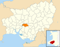 Wales Carmarthenshire Community Llangunnor map.svg 512 × 399; 1,12 MB
-

-

-

-
 Yn cwrdd a'r B4300 - Joining the B4300 - geograph.org.uk - 5903489.jpg 1 024 × 767; 322 KB
-
 Above Ty Llwyd Mawr - geograph.org.uk - 359613.jpg 640 × 480; 90 KB
-
 Campsite - geograph.org.uk - 148426.jpg 640 × 480; 349 KB
-
 Country lane - geograph.org.uk - 148449.jpg 480 × 640; 462 KB
-

-
 Erw Wen St Davids Day 2006 - geograph.org.uk - 361472.jpg 640 × 480; 95 KB
-
 Farmland near Coed Adam - geograph.org.uk - 580303.jpg 640 × 480; 92 KB
-
 Farmland near Nantycaws - geograph.org.uk - 580312.jpg 640 × 480; 80 KB
-
 Houses at Bwlchymynydd - geograph.org.uk - 580317.jpg 640 × 480; 97 KB
-
 Junction - geograph.org.uk - 148435.jpg 640 × 480; 430 KB
-
 Tywi in flood, nr Carmarthen. - geograph.org.uk - 76381.jpg 640 × 480; 138 KB


_rivers_-_geograph.org.uk_-_2824268.jpg)


.jpg)
.jpg)


.jpg)


_-_geograph.org.uk_-_3583452.jpg)


