Category:Llangyfelach
Aller à la navigation
Aller à la recherche
village britannique  | |||||
| Téléverser des médias | |||||
| Nature de l’élément | |||||
|---|---|---|---|---|---|
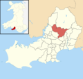
| Lieu | Swansea, pays de Galles | ||||
| Population |
| ||||
| Superficie |
| ||||
 | |||||
Cymraeg: Pentref a chymuned yn ninas a sir Abertawe yw Llangyfelach. Saif tua pedair milltir i'r gogledd o ganol dinas Abertawe, ac i'r gorllewin o Dreforys. Mae traffordd yr M4 ychydig i'r gogledd.
English: The village of Llangyfelach is located in the City and County of Swansea, Wales, UK. Llangyfelach is situated about 4 miles north of Swansea city centre, just west of Morriston, however, it has still retained its village feel and identity. It falls within the Llangyfelach ward. To the west is open moorland.
Sous-catégories
Cette catégorie comprend seulement la sous-catégorie ci-dessous.
S
Média dans la catégorie « Llangyfelach »
Cette catégorie comprend 86 fichiers, dont les 86 ci-dessous.
-
 2010 Wales Swansea Community Llangyfelach map.svg 512 × 472 ; 632 kio
-
 2024 Wales Swansea Community Llangyfelach map.svg 512 × 472 ; 651 kio
-
 A48 roundabout - geograph.org.uk - 6059224.jpg 2 048 × 1 536 ; 1,66 Mio
-
 Approaching Llangyfelach tunnel 29th July 2006.jpg 800 × 600 ; 94 kio
-
 Barrier on Penplas Road near Cefn Cadle Farm - geograph.org.uk - 1049399.jpg 640 × 480 ; 89 kio
-
 Bridge and ford at Pont-Lasau - geograph.org.uk - 6180639.jpg 2 048 × 1 536 ; 1,04 Mio
-
 Bus Stop View - geograph.org.uk - 2616909.jpg 800 × 600 ; 140 kio
-
 Cascades of stream in Penllergaer Forest - geograph.org.uk - 3434881.jpg 1 024 × 768 ; 231 kio
-
 Cefnfforest Fawr - geograph.org.uk - 5864180.jpg 2 448 × 3 264 ; 3,31 Mio
-
 Cil Fwnwr - geograph.org.uk - 6059682.jpg 2 048 × 1 536 ; 1,04 Mio
-
 Cil Fwnwr Farm - geograph.org.uk - 6061656.jpg 2 429 × 1 647 ; 1,89 Mio
-
 Coed Cae Croes - geograph.org.uk - 5864189.jpg 3 264 × 2 448 ; 2,64 Mio
-
 Construction site, Llangyfelach - geograph.org.uk - 4014677.jpg 2 288 × 1 712 ; 715 kio
-
 Cyffordd o draciau - junction of tracks - geograph.org.uk - 3874690.jpg 640 × 480 ; 148 kio
-
 Development site, Pengors Road - geograph.org.uk - 2814050.jpg 640 × 480 ; 64 kio
-
 Divergence on the river Llan - geograph.org.uk - 3456470.jpg 1 024 × 768 ; 244 kio
-
 Electricity substation - geograph.org.uk - 6178648.jpg 2 048 × 1 536 ; 986 kio
-

-
 Entrance to the DVLA - geograph.org.uk - 6059239.jpg 2 902 × 2 087 ; 1,54 Mio
-
 Felindre Road - geograph.org.uk - 5864177.jpg 2 448 × 3 264 ; 2,8 Mio
-
 Footbridge over stream - geograph.org.uk - 6178302.jpg 2 448 × 3 264 ; 3,28 Mio
-
 Footbridge over the M4 - geograph.org.uk - 3688706.jpg 640 × 430 ; 48 kio
-
 Footbridge over the River Llan - geograph.org.uk - 3435632.jpg 1 024 × 768 ; 246 kio
-
 Ford and bridge - geograph.org.uk - 6178293.jpg 3 264 × 2 448 ; 3,85 Mio
-

-
 Greenfield Kennels - geograph.org.uk - 6059227.jpg 3 264 × 2 448 ; 3,6 Mio
-
 Half mile to Swansea West Services - geograph.org.uk - 3688705.jpg 640 × 406 ; 42 kio
-
 Hen heol Maes Eglwys - Maes Eglwys old road - geograph.org.uk - 3875830.jpg 640 × 480 ; 145 kio
-
 Heol Ffarm Tirdoncyn Access Road - geograph.org.uk - 3880437.jpg 640 × 480 ; 145 kio
-
 Heol Tir Doncyn Road - geograph.org.uk - 3880424.jpg 640 × 480 ; 146 kio
-
 Heol y Geifr - geograph.org.uk - 3848305.jpg 640 × 425 ; 117 kio
-
 Llangyfelach School - geograph.org.uk - 3751711.jpg 640 × 480 ; 64 kio
-
 Llwybr glanafon Llan riverside path - geograph.org.uk - 2782043.jpg 690 × 518 ; 242 kio
-
 Llwybr Pen Plas Footpath - geograph.org.uk - 3880336.jpg 640 × 480 ; 118 kio
-
 Long abandoned farm track from Penplas Road - geograph.org.uk - 1049414.jpg 480 × 640 ; 96 kio
-
 M4 eastbound at junction 47 - geograph.org.uk - 4346642.jpg 1 600 × 1 062 ; 385 kio
-
 M4 eastbound towards junction 45 - geograph.org.uk - 4346895.jpg 1 600 × 1 062 ; 468 kio
-
 M4 eastbound towards junction 46 - geograph.org.uk - 4346641.jpg 1 600 × 1 062 ; 386 kio
-
 M4 eastbound towards junction 46 - geograph.org.uk - 4346896.jpg 1 600 × 1 062 ; 499 kio
-
 M4 junction 46 - geograph.org.uk - 3125383.jpg 640 × 406 ; 53 kio
-
 M4 slip road joins at Junction 46 westbound - geograph.org.uk - 2935444.jpg 640 × 481 ; 37 kio
-
 M4 westbound - geograph.org.uk - 2935448.jpg 640 × 480 ; 46 kio
-
 M4 westbound approaching Junction 46 - geograph.org.uk - 2935440.jpg 640 × 480 ; 44 kio
-
 M4 westbound approaching junction 47 - geograph.org.uk - 5825521.jpg 1 600 × 1 200 ; 699 kio
-
 M4, Junction 46 - geograph.org.uk - 3688680.jpg 640 × 388 ; 29 kio
-
 M4, Junction 47 - geograph.org.uk - 3688707.jpg 640 × 385 ; 38 kio
-
 M4, west of Junction 46 - geograph.org.uk - 3688685.jpg 640 × 403 ; 39 kio
-
 Minor road bridge over M4 - geograph.org.uk - 3125365.jpg 640 × 449 ; 80 kio
-
 Minor road to Maes-eglwys from Pantlasau, Swansea - geograph.org.uk - 5943365.jpg 843 × 1 024 ; 224 kio
-

-
 One mile from junction 46 M4 - geograph.org.uk - 3125379.jpg 640 × 422 ; 70 kio
-
 Ordnance Survey Pivot - geograph.org.uk - 4821259.jpg 480 × 640 ; 107 kio
-
 Pasture by Penplas Road - geograph.org.uk - 1042553.jpg 640 × 510 ; 103 kio
-
 Pasture edge - geograph.org.uk - 1045030.jpg 640 × 480 ; 89 kio
-
 Pasture near Brynwhilhach - geograph.org.uk - 1042539.jpg 640 × 480 ; 108 kio
-
 Penllergaer Business Park - geograph.org.uk - 6059467.jpg 2 048 × 1 536 ; 1,07 Mio
-
 Penllergaer Business Park - geograph.org.uk - 6059470.jpg 2 048 × 1 536 ; 1,15 Mio
-
 Penplas Road - geograph.org.uk - 1045036.jpg 640 × 480 ; 80 kio
-
 Penywaun Fach - geograph.org.uk - 3848510.jpg 640 × 373 ; 59 kio
-
 Pit Stop Cafe - geograph.org.uk - 2616918.jpg 800 × 600 ; 121 kio
-
 Plough and Harrow (geograph 6059191).jpg 2 048 × 1 536 ; 824 kio
-
 Quarry remains in Penllergaer Forest - geograph.org.uk - 3434851.jpg 1 024 × 768 ; 262 kio
-
 Remnants of a Hydraulic Ram pump - geograph.org.uk - 3434896.jpg 600 × 800 ; 118 kio
-
 Road to Felindre - geograph.org.uk - 1045027.jpg 640 × 480 ; 121 kio
-
 Rushing to work - geograph.org.uk - 1042548.jpg 640 × 480 ; 121 kio
-
 Sixty ^ - geograph.org.uk - 1049402.jpg 640 × 480 ; 100 kio
-
 Stile exiting Penllergaer Forest to railway crossing - geograph.org.uk - 3435608.jpg 1 024 × 768 ; 256 kio
-
 Swansea , M4 Motorway - geograph.org.uk - 3926782.jpg 4 288 × 2 848 ; 4,02 Mio
-
 Swansea , M4 Motorway - geograph.org.uk - 3926785.jpg 4 288 × 2 848 ; 4,09 Mio
-
 Swansea , M4 Motorway - geograph.org.uk - 3926786.jpg 4 288 × 2 848 ; 4,58 Mio
-
 Swansea , M4 Motorway - geograph.org.uk - 3927281.jpg 4 288 × 2 848 ; 5,41 Mio
-
 Swansea , M4 Motorway - geograph.org.uk - 3927283.jpg 4 288 × 2 848 ; 5,22 Mio
-
 Swansea , M4 Motorway - geograph.org.uk - 3927285.jpg 4 288 × 2 848 ; 5,74 Mio
-
 Swansea UK ward location - Llangyfelach.png 800 × 768 ; 143 kio
-
 The Plough and Harrow - geograph.org.uk - 496019.jpg 640 × 474 ; 52 kio
-
 Trac Cefn y Fforest Track - geograph.org.uk - 3873328.jpg 640 × 480 ; 132 kio
-
 Trac Coed Penllergaer Forest Track - geograph.org.uk - 3873415.jpg 640 × 480 ; 148 kio
-
 Trac Coed Penllergaer Woods track - geograph.org.uk - 3874697.jpg 640 × 480 ; 116 kio
-
 Track to the quarry in Penllergaer Forest - geograph.org.uk - 3434869.jpg 1 024 × 768 ; 215 kio
-
 Trackway strewn with rubbish - geograph.org.uk - 2219014.jpg 640 × 480 ; 82 kio
-
 Trackway turns into a 4x4 playground - geograph.org.uk - 2219028.jpg 640 × 480 ; 50 kio
-
 Triangulation post in Penllegaer Forest - geograph.org.uk - 794696.jpg 640 × 480 ; 99 kio
-
 View along a track in Penllergaer Forest - geograph.org.uk - 3434904.jpg 1 024 × 768 ; 198 kio
-
 Wales Audit Office - geograph.org.uk - 6059464.jpg 2 048 × 1 536 ; 1,77 Mio
-
 Waun Ffyrdd - geograph.org.uk - 3848530.jpg 640 × 380 ; 63 kio
-
 Westbound on slip for junction 46 of M4 - geograph.org.uk - 5825514.jpg 1 600 × 1 200 ; 786 kio


.jpg)


