Category:Llanhilleth
Vai alla navigazione
Vai alla ricerca
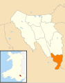
comunità del Galles   | |||||
| Carica un file multimediale | |||||
| Istanza di | |||||
|---|---|---|---|---|---|
| Luogo | Blaenau Gwent, Galles | ||||
| Popolazione |
| ||||
| Superficie |
| ||||
 | |||||

Cymraeg: Llanhiledd
Sottocategorie
Questa categoria contiene le 8 sottocategorie indicate di seguito, su un totale di 8.
C
- Cae Felin Street (2 F)
- Cwm Cyffin (2 F)
G
- Glandwr Industrial Estate (2 F)
H
- Hyde Street, Llanhilleth (2 F)
I
L
- Llanhilleth railway station (11 F)
File nella categoria "Llanhilleth"
Questa categoria contiene 200 file, indicati di seguito, su un totale di 276.
(pagina precedente) (pagina successiva)-
 "Keep off the grass", Llanhilleth - geograph.org.uk - 1157326.jpg 640 × 480; 90 KB
-
 2010 Wales Blaenau Gwent Community Llanhilleth map.svg 512 × 655; 233 KB
-
 20191020 Blaencuffin Canyon 1.jpg 4 160 × 2 340; 3,77 MB
-
 20191020 Blaencuffin Canyon 2.jpg 4 160 × 2 340; 3,69 MB
-
 20191020 Blaencuffin Canyon 3.jpg 5 694 × 2 256; 2,75 MB
-
 20191020 Blaencuffin Canyon 4.jpg 4 160 × 2 340; 3,76 MB
-
 20191020 Blaencuffin Canyon 5.jpg 4 160 × 2 340; 3,42 MB
-
 20191020 Blaencuffin Canyon 6.jpg 4 160 × 2 340; 4,42 MB
-
 20191020 Blaencuffin Canyon falls.jpg 4 160 × 2 340; 3,77 MB
-
 2024 Wales Blaenau Gwent Community Llanhilleth map.svg 512 × 655; 238 KB
-
 A view from Sofrydd Road, Sofrydd - geograph.org.uk - 2635159.jpg 640 × 572; 123 KB
-

-
 A.P.Webb Super Railer at Llanhilleth - geograph.org.uk - 2766111.jpg 640 × 557; 156 KB
-
 A467 near Aberbeeg - geograph.org.uk - 2751435.jpg 640 × 480; 59 KB
-
 A467 overbridge, Aberbeeg - geograph.org.uk - 5597013.jpg 800 × 648; 139 KB
-
 Aberbeeg Community Centre, Aberbeeg - geograph.org.uk - 5596994.jpg 800 × 725; 152 KB
-
 Aberbeeg Funeral Home, Aberbeeg - geograph.org.uk - 5596996.jpg 800 × 597; 115 KB
-
 Aberbeeg Gauging Station, Ebbw River - geograph.org.uk - 4595820.jpg 5 016 × 2 938; 4,87 MB
-

-
 Aberbeeg railway bridge - geograph.org.uk - 1932297.jpg 640 × 616; 113 KB
-
 Aberbeeg Weir, Ebbw River - geograph.org.uk - 4595838.jpg 4 676 × 3 218; 5,4 MB
-
 Access ramp to bed of River Ebbw, Aberbeeg - geograph.org.uk - 5087642.jpg 5 179 × 3 451; 5,57 MB
-
 Access to Ebbw Fach Trail, Aberbeeg - geograph.org.uk - 5051941.jpg 5 179 × 3 451; 7,33 MB
-
 ACF hut dwarfed by pylon, Sofrydd - geograph.org.uk - 2482500.jpg 568 × 640; 74 KB
-
 ACF hut, Sofrydd - geograph.org.uk - 2482506.jpg 640 × 415; 72 KB
-
 Acre Close, Sofrydd - geograph.org.uk - 2482797.jpg 640 × 480; 76 KB
-
 Across the valley towards Lewis Street, Swffryd - geograph.org.uk - 5081802.jpg 5 184 × 3 456; 3,1 MB
-
 Aerial View of Llanhilleth - geograph.org.uk - 633710.jpg 640 × 480; 71 KB
-

-
 Aneurin Avenue, Sofrydd - geograph.org.uk - 2482934.jpg 640 × 480; 58 KB
-
 Approaching Aberbeeg - geograph.org.uk - 3904769.jpg 954 × 1 596; 368 KB
-

-
 B4471 Commercial Road, Aberbeeg - geograph.org.uk - 6178230.jpg 1 024 × 767; 204 KB
-
 B4471 reaches Sofrydd - geograph.org.uk - 2635174.jpg 640 × 490; 86 KB
-
 B4471 road.jpg 5 472 × 3 648; 5,55 MB
-
 Baillie Smith Avenue, Sofrydd - geograph.org.uk - 2635052.jpg 640 × 599; 83 KB
-
 Base of The Canyon - geograph.org.uk - 5403622.jpg 5 179 × 3 451; 5,75 MB
-
 Beech tree, Cwm Big, Aberbeeg - geograph.org.uk - 4842542.jpg 5 179 × 3 451; 4,36 MB
-
 Below Commercial Road - geograph.org.uk - 3904756.jpg 1 074 × 1 596; 400 KB
-
 Bethesda Pentecostal Chapel, Sofrydd - geograph.org.uk - 2482545.jpg 640 × 480; 79 KB
-
 Blaen-cyffin - geograph.org.uk - 3081640.jpg 1 024 × 680; 164 KB
-
 Bowling green, Llanhilleth - geograph.org.uk - 2765949.jpg 640 × 480; 83 KB
-
 Brewery Court, Aberbeeg - geograph.org.uk - 5221319.jpg 800 × 676; 125 KB
-
 Brewery Terrace, Aberbeeg - geograph.org.uk - 1932236.jpg 640 × 450; 87 KB
-
 Brewery Terrace, Aberbeeg - geograph.org.uk - 5221261.jpg 800 × 492; 130 KB
-
 Bridge construction work, River Ebbw, Aberbeeg - geograph.org.uk - 5087618.jpg 5 179 × 3 451; 6,1 MB
-
 Bridge construction work, River Ebbw, Aberbeeg, November - geograph.org.uk - 5204747.jpg 5 179 × 3 451; 5,14 MB
-
 Bridge construction work, River Ebbw, Aberbeeg, October - geograph.org.uk - 5173793.jpg 5 179 × 3 451; 5,17 MB
-
 Bridge over River Ebbw, Glandwr - geograph.org.uk - 5174420.jpg 4 810 × 3 206; 3,48 MB
-
 Bronawelon, Sofrydd - geograph.org.uk - 3999868.jpg 1 600 × 1 064; 279 KB
-
 Brooklyn Terrace, Llanhilleth - geograph.org.uk - 2637270.jpg 640 × 494; 86 KB
-
 Brynithel from the air - geograph.org.uk - 2116001.jpg 2 592 × 1 944; 3,34 MB
-

-
 Carpenters Arms, St Illtyd - geograph.org.uk - 3077855.jpg 1 024 × 680; 196 KB
-
 Cattle grid on Mynydd Llanhilleth - geograph.org.uk - 3081646.jpg 1 024 × 680; 191 KB
-

-
 Christ Church, Aberbeeg - geograph.org.uk - 4807940.jpg 5 179 × 3 451; 4,52 MB
-
 Churchyard, St Illtyd - geograph.org.uk - 5543915.jpg 5 179 × 3 451; 6,3 MB
-
 Churchyard, St Illtyd, above Brynithel - geograph.org.uk - 5116287.jpg 5 184 × 3 456; 6,32 MB
-
 Class 37 locomotive near Llanhilleth - geograph.org.uk - 5845275.jpg 3 241 × 4 321; 5 MB
-

-
 Commercial Road houses, Llanhilleth - geograph.org.uk - 2825480.jpg 640 × 480; 100 KB
-
 Commercial Road towards Aberbeeg - geograph.org.uk - 3998010.jpg 1 600 × 1 232; 754 KB
-
 Commercial Road, Llanhilleth.jpg 4 646 × 3 256; 4,13 MB
-
 Cone of quarry spoil,The Canyon - geograph.org.uk - 5404533.jpg 5 184 × 3 456; 7,11 MB
-
 Confluence of Ebbw Rivers, Aberbeeg - geograph.org.uk - 5230402.jpg 5 179 × 3 451; 6,06 MB
-
 Confluence of Ebbw Rivers, Aberbeeg - geograph.org.uk - 5329886.jpg 5 179 × 3 451; 4,05 MB
-
 Confluence of Ebbw ^ Ebbw Fach Rivers, Aberbeeg - geograph.org.uk - 4595872.jpg 4 941 × 3 206; 5,66 MB
-
 Construction of approach to new cycle bridge, Aberbeeg - geograph.org.uk - 5230377.jpg 5 184 × 3 456; 6,15 MB
-
 Construction of bridge pier, Aberbeeg, October - geograph.org.uk - 5174168.jpg 5 179 × 3 451; 4,07 MB
-
 Construction of bridge support, Aberbeeg, November - geograph.org.uk - 5204744.jpg 5 179 × 3 451; 5,99 MB
-
 Construction of bridge support, Aberbeeg, October - geograph.org.uk - 5173836.jpg 5 179 × 3 451; 4,43 MB
-
 Construction of ramp to new cycle bridge, Aberbeeg - geograph.org.uk - 5261514.jpg 5 184 × 3 456; 7,13 MB
-
 Construction work for bridge, River Ebbw, Aberbeeg - geograph.org.uk - 5088251.jpg 5 179 × 3 451; 6,11 MB
-
 Construction yard for cycle bridge, Aberbeeg - geograph.org.uk - 5230390.jpg 5 179 × 3 451; 5,11 MB
-

-
 Countryside Wales.jpg 7 878 × 2 088; 6,68 MB
-
 Crumlin Road south of Llanhilleth - geograph.org.uk - 2635466.jpg 640 × 480; 109 KB
-
 Crumlin Road, Llanhilleth - geograph.org.uk - 3085082.jpg 1 024 × 680; 252 KB
-
 Cwm Cnyw - geograph.org.uk - 5405136.jpg 5 179 × 3 451; 5,35 MB
-
 Cycle route 465 in Aberbeeg - geograph.org.uk - 5222018.jpg 800 × 711; 174 KB
-

-
 Danger of Death.jpg 3 648 × 5 472; 3,89 MB
-
 De-consecrated church of St Illtyd, near Llanhilleth - geograph.org.uk - 4093427.jpg 2 560 × 1 920; 2,18 MB
-
 Derelict building on the High Street, Llanhilleth - geograph.org.uk - 3997972.jpg 1 600 × 1 064; 721 KB
-
 Derelict former fish bar, Sofrydd - geograph.org.uk - 2482812.jpg 640 × 473; 79 KB
-

-
 Derelict pit head baths, Llanhilleth - geograph.org.uk - 3085070.jpg 1 024 × 680; 226 KB
-

-

-

-
 Drain off Cefn Crib - geograph.org.uk - 5405160.jpg 5 179 × 3 451; 5,9 MB
-
 Eastern end of Rectory Road, Sofrydd - geograph.org.uk - 2482480.jpg 640 × 480; 112 KB
-
 Ebbw Fach River behind Woodland Terrace, Aberbeeg - geograph.org.uk - 5051910.jpg 5 179 × 3 451; 5,96 MB
-
 Ebbw Fach Trail behind Woodland Terrace, Aberbeeg - geograph.org.uk - 5051925.jpg 5 179 × 3 451; 5,63 MB
-
 Ebbw river, Aberbeeg - geograph.org.uk - 1932317.jpg 640 × 516; 145 KB
-
 Ebbw River, near Railway Terrace, Aberbeeg - geograph.org.uk - 4595799.jpg 4 904 × 3 104; 5,89 MB
-
 Ebbw River, near Railway Terrace, Aberbeeg, Summer - geograph.org.uk - 4631338.jpg 2 987 × 2 119; 2,23 MB
-
 Ebbw River, near Railway Terrace, Aberbeeg, Winter - geograph.org.uk - 4631362.jpg 2 973 × 2 005; 1,94 MB
-
 Ebbw River, Railway Terrace, Aberbeeg - geograph.org.uk - 4595782.jpg 4 760 × 2 911; 5,03 MB
-
 Edge of Cefn Crib - geograph.org.uk - 5405145.jpg 5 184 × 3 456; 7,62 MB
-
 Electricity pylon, Sofrydd - geograph.org.uk - 2635111.jpg 480 × 640; 75 KB
-

-
 Entrance to Aberbeeg Medical Centre - geograph.org.uk - 1932255.jpg 640 × 480; 110 KB
-
 Farmland near St Illtyd - geograph.org.uk - 3077848.jpg 1 024 × 680; 212 KB
-
 Feces in Wales.jpg 2 090 × 1 230; 1,06 MB
-
 Field behind farmyard, St Illtyd - geograph.org.uk - 5544128.jpg 5 179 × 3 451; 5,04 MB
-
 Flyover Garage, Aberbeeg - geograph.org.uk - 5597018.jpg 800 × 621; 131 KB
-
 Forestry Road, Cwm Big, Aberbeeg - geograph.org.uk - 4842521.jpg 5 179 × 3 451; 4,37 MB
-
 Forestry Road, up Cwm Big, Aberbeeg - geograph.org.uk - 4842527.jpg 5 179 × 3 451; 5,6 MB
-
 Former play area, Llanhilleth - geograph.org.uk - 2765937.jpg 640 × 480; 119 KB
-
 Former Wesleyan Church, High Street, Llanhilleth - geograph.org.uk - 3997984.jpg 1 600 × 1 064; 630 KB
-

-
 Gate and cattle grid, Cefn Crib - geograph.org.uk - 5405176.jpg 5 179 × 3 451; 3,89 MB
-
 Gate in Wales.jpg 3 434 × 2 289; 3,81 MB
-
 Go Go Wok, Llanhilleth - geograph.org.uk - 2825390.jpg 606 × 640; 108 KB
-
 Gordon Avenue, Sofrydd - geograph.org.uk - 2635089.jpg 640 × 499; 90 KB
-

-
 Hafodarthen road - geograph.org.uk - 731749.jpg 640 × 480; 74 KB
-
 Hafodarthen Road, Llanhilleth - geograph.org.uk - 2825519.jpg 640 × 480; 86 KB
-
 Hector Avenue - geograph.org.uk - 3114108.jpg 640 × 480; 44 KB
-
 Hector Avenue, Sofrydd - geograph.org.uk - 2482939.jpg 640 × 480; 63 KB
-

-
 High Street Llanhilleth - geograph.org.uk - 2636878.jpg 637 × 640; 120 KB
-
 High Street, Llanhilleth - geograph.org.uk - 3085246.jpg 1 024 × 680; 211 KB
-

-
 Hillside houses, Brynithel - geograph.org.uk - 2830781.jpg 640 × 480; 128 KB
-
 Hillside terraces, Llanhilleth - geograph.org.uk - 1157328.jpg 640 × 480; 55 KB
-

-

-

-

-

-

-
 Keir Hardie Terrace, Sofrydd - geograph.org.uk - 2635096.jpg 640 × 510; 78 KB
-
 Keir Hardie Terrace, Sofrydd - geograph.org.uk - 3999875.jpg 1 600 × 1 064; 356 KB
-
 Lane to Maes-y-cnyw Farm - geograph.org.uk - 5405126.jpg 5 179 × 3 451; 5,59 MB
-
 Lewis Street, Sofrydd - geograph.org.uk - 2482636.jpg 640 × 498; 78 KB
-
 Llanhilleth - Commercial Road.jpg 4 955 × 3 539; 5,4 MB
-
 Llanhilleth 2.jpg 5 472 × 3 648; 5,48 MB
-
 Llanhilleth 2018.jpg 3 737 × 2 519; 2,76 MB
-
 Llanhilleth 3.jpg 7 878 × 2 358; 6,19 MB
-
 Llanhilleth Colliery Memorial, Granny's Wood (geograph 7241714).jpg 5 179 × 3 451; 6,34 MB
-

-
 Llanhilleth Convenience Store - geograph.org.uk - 2766014.jpg 640 × 585; 100 KB
-
 Llanhilleth footbridge - geograph.org.uk - 2825566.jpg 640 × 480; 76 KB
-
 Llanhilleth Hotel - geograph.org.uk - 3077863.jpg 1 024 × 680; 201 KB
-
 Llanhilleth Hotel, Llanhilleth - geograph.org.uk - 2637213.jpg 640 × 474; 87 KB
-
 Llanhilleth Park - geograph.org.uk - 2825146.jpg 640 × 479; 61 KB
-
 Llanhilleth Police Station - geograph.org.uk - 2636924.jpg 640 × 536; 94 KB
-
 Llanhilleth post office - geograph.org.uk - 2636998.jpg 475 × 640; 60 KB
-
 Llanhilleth railway station - geograph.org.uk - 2825409.jpg 640 × 480; 83 KB
-
 Llanhilleth RUFC - geograph.org.uk - 3998018.jpg 1 600 × 921; 552 KB
-
 Llanhilleth Workman's Institute - geograph.org.uk - 201948.jpg 640 × 480; 120 KB
-

-
 Llanhilleth.jpg 5 472 × 3 089; 5,52 MB
-
 Lloyd Avenue, Sofrydd - geograph.org.uk - 2635047.jpg 640 × 434; 67 KB
-

-

-

-

-
 Looking towards Mount Pleasant - geograph.org.uk - 1142016.jpg 640 × 480; 84 KB
-
 Low railway bridge in Aberbeeg - geograph.org.uk - 5596938.jpg 800 × 600; 109 KB
-
 Lower Court Terrace, Llanhilleth - geograph.org.uk - 2825500.jpg 640 × 480; 82 KB
-
 Meadow Street Llanhilleth - geograph.org.uk - 2825385.jpg 640 × 462; 74 KB
-

-

-
 Minor road to Cefn Crib cattle grid - geograph.org.uk - 5405192.jpg 5 179 × 3 451; 5,71 MB
-
 Mynydd Llanhilleth - geograph.org.uk - 3083185.jpg 1 024 × 680; 230 KB
-
 Nant Big, Aberbeeg - geograph.org.uk - 4842552.jpg 5 179 × 3 451; 5,05 MB
-

-
 New cycle bridge, Aberbeeg - geograph.org.uk - 5329910.jpg 5 179 × 3 451; 4,69 MB
-
 New cycle route bridge over River Ebbw, Aberbeeg - geograph.org.uk - 5230370.jpg 4 810 × 3 206; 3,53 MB
-

-

-

-

-

-
 Northwest end of pond, The Canyon - geograph.org.uk - 5404430.jpg 5 179 × 3 451; 4,94 MB
-
 Ordnance Survey Cut Mark - geograph.org.uk - 4935687.jpg 480 × 640; 103 KB
-
 Otter walkway, Ebbw River, Aberbeeg - geograph.org.uk - 4842389.jpg 5 179 × 3 451; 5,37 MB
-
 Pantddu Road river bridge, Aberbeeg - geograph.org.uk - 5597020.jpg 800 × 498; 162 KB
-
 Path, St Illtyd churchyard - geograph.org.uk - 5116328.jpg 5 184 × 3 456; 7,48 MB
-
 Playground, Aberbeeg - geograph.org.uk - 5329927.jpg 5 179 × 3 451; 4,68 MB
-
 Playpark and recreation ground, Llanhilleth - geograph.org.uk - 3725543.jpg 4 320 × 3 240; 5,67 MB
-
 Pond, The Canyon - geograph.org.uk - 5403660.jpg 5 179 × 3 451; 4,23 MB
-

-
 Prospect Place, Llanhilleth - geograph.org.uk - 2636685.jpg 580 × 640; 80 KB
-
 Railtour heads back down the valley - geograph.org.uk - 2433994.jpg 640 × 416; 99 KB
-
 Railway bridge Ebbw Fach River, Aberbeeg - geograph.org.uk - 4674786.jpg 5 144 × 3 376; 4,88 MB
-
 Railway bridge over Ebbw Fach River, Aberbeeg - geograph.org.uk - 5230341.jpg 5 179 × 3 451; 5,51 MB
-
 Railway footbridge, Llanhilleth - geograph.org.uk - 2766049.jpg 640 × 480; 79 KB
-
 Railway in Llanhilleth - geograph.org.uk - 5237012.jpg 3 728 × 2 796; 4 MB
-

-
 Railway St, Llanhilleth - geograph.org.uk - 1157318.jpg 640 × 480; 67 KB
-
 Railway Street - geograph.org.uk - 3282301.jpg 640 × 480; 93 KB
-
 Railway Street in Llanhilleth - geograph.org.uk - 5237018.jpg 4 000 × 3 000; 4,64 MB
-
 Railway Terrace houses, Aberbeeg - geograph.org.uk - 5222001.jpg 800 × 600; 120 KB
-
 Railway Terrace ^ River Ebbw, Aberbeeg - geograph.org.uk - 4926257.jpg 5 179 × 3 451; 5,43 MB
-
 Railway Terrace, Aberbeeg - geograph.org.uk - 4750529.jpg 5 184 × 3 456; 7 MB


.jpg)


