Category:Lohmar
Aller à la navigation
Aller à la recherche
Rhein-Sieg-Kreis  Alfter · Bad Honnef · Bornheim · Eitorf · Hennef · Königswinter · Lohmar · Meckenheim · Much · Neunkirchen-Seelscheid · Niederkassel · Rheinbach · Ruppichteroth · Sankt Augustin · Siegburg · Swisttal · Troisdorf · Wachtberg · Windeck ·

ville d'Allemagne  Bydelen Honrath med den evangeliske kirken    | |||||
| Téléverser des médias | |||||
| Nature de l’élément |
| ||||
|---|---|---|---|---|---|
| Lieu | arrondissement de Rhin-Sieg, district de Cologne, Rhénanie-du-Nord-Westphalie, Allemagne | ||||
| Chef ou cheffe de l'exécutif |
| ||||
| Population |
| ||||
| Superficie |
| ||||
| Altitude |
| ||||
| À ne pas confondre avec | |||||
| site officiel | |||||
 | |||||
Sous-catégories
Cette catégorie comprend 16 sous-catégories, dont les 16 ci-dessous.
Média dans la catégorie « Lohmar »
Cette catégorie comprend 86 fichiers, dont les 86 ci-dessous.
-
 A3 - Ausfahrt - A484 bei Lohmar Nord - geo-en.hlipp.de - 12242.jpg 640 × 449 ; 43 kio
-
 A3 - Kreuz 30b - Lohmar-Nord (500m) - geo-en.hlipp.de - 11082.jpg 640 × 444 ; 57 kio
-
 A3 - Kreuz 30b, Lohmar-Nord - geo-en.hlipp.de - 12241.jpg 640 × 480 ; 59 kio
-
 A380 - panoramio.jpg 1 628 × 1 348 ; 972 kio
-
 Bahnhof Wahlscheid, Baudenkmal der Stadt Lohmar Nr. 46 am 29. April 2015 - 2.jpg 4 669 × 3 280 ; 2,59 Mio
-
 Bahnhof Wahlscheid, Baudenkmal der Stadt Lohmar Nr. 46 am 29. April 2015.jpg 4 034 × 3 162 ; 1,61 Mio
-
 Bahnhofsschild des alten Bahnhofes Wahlscheid, Baudenkmal der Stadt Lohmar Nr. 46.jpg 4 725 × 4 007 ; 18,9 Mio
-
 Bank mit Blick ins Naafbachtal auf dem Rundwanderweg des SGV von Höffen ins Naafbachtal.jpg 4 623 × 3 120 ; 8,38 Mio
-
 Bf-honrath.jpg 1 984 × 1 436 ; 2,38 Mio
-
 Bodendenkmal-1-69.jpg 1 269 × 981 ; 448 kio
-
 Brückenhaus in Schiffart am 29. April 2015.jpg 4 882 × 3 302 ; 1,82 Mio
-
 Burg Honrath.jpg 6 262 × 4 748 ; 2,12 Mio
-
De-Lohmar.ogg 1,9 s ; 18 kio
-
 Die Dornenkrone vom Wegekreuz Rosauel.jpg 3 729 × 2 999 ; 1,06 Mio
-
 Ehemalige Traditionsgaststätte Onkel Hugo in Scheid.jpg 3 202 × 2 521 ; 3,74 Mio
-
 Evangelische Sankt Bartholomäus Kirche auf dem Berge in Alt-Wahlscheid 2013-12-29.jpg 3 539 × 3 102 ; 1,18 Mio
-
 Fachwerkhaus Gut Rosauel am 29. April 2015.jpg 5 184 × 3 456 ; 2,74 Mio
-
 Fachwerkhaus Schachenaueler Straße 56 Denkmalliste Nr 107.jpg 6 093 × 4 665 ; 28,47 Mio
-
 Fischteiche in Lohmar - Neuenhof.jpg 4 774 × 3 238 ; 8,06 Mio
-
 Giebel des Bahnhofes Wahlscheid, Baudenkmal der Stadt Lohmar Nr. 46 am 31. Dezember 2013.jpg 5 128 × 3 369 ; 8,01 Mio
-
 Glückliche Kühe - panoramio.jpg 3 264 × 2 448 ; 2,63 Mio
-
 Gut Rosauel am 15. Juli 2015.jpg 5 034 × 3 813 ; 2,33 Mio
-
 Gut Windlöck Denkmalliste Nr 130 am 18.3.2014.jpg 2 823 × 1 996 ; 2,01 Mio
-
 Gut Windlöck Denkmalliste Nr 130 am 30.12.2010.jpg 3 876 × 2 907 ; 716 kio
-
 Höffen - panoramio.jpg 3 264 × 2 448 ; 3,19 Mio
-
 Hölzernes Wegekreuz in Lohmar - Hohn.jpg 3 524 × 2 818 ; 1,12 Mio
-
 Inger-Birker-Straße-8-Schulgebäude.JPG 3 745 × 2 832 ; 1,86 Mio
-
 Inger-Ingerer-Straße-24-Fachwerkhaus.JPG 3 911 × 2 970 ; 2 Mio
-
 Inschrift am Fachwerkhaus Schachenaueler Straße 56 Denkmalliste Nr 107.jpg 3 775 × 2 520 ; 1,06 Mio
-
 Kerner Laube in Lohmar - Kern bei einer Regenwanderung.jpg 4 624 × 3 196 ; 7,27 Mio
-
 Kreuz 30b (A3) - Lohmar Nord (1000 m) - geo.hlipp.de - 6102.jpg 640 × 388 ; 35 kio
-
 Kreuz 31 (A3) - Lohmar (1000 m) - geo.hlipp.de - 6100.jpg 640 × 394 ; 43 kio
-
 Kruzifix des Wegekreuzes Holl am 4. November 2015.JPG 4 000 × 3 000 ; 4,01 Mio
-
 L484 - L507 bei Lohmar - geo.hlipp.de - 12244.jpg 640 × 480 ; 70 kio
-
 L484 bei Lohmar - geo.hlipp.de - 12243.jpg 640 × 436 ; 59 kio
-
 Lohmar - Bahntrassenradweg - geo.hlipp.de - 37346.jpg 426 × 568 ; 68 kio
-
 Lohmar - Jabachhalle - geo.hlipp.de - 38733.jpg 568 × 426 ; 45 kio
-
 Lohmar - Krewelshof - geo.hlipp.de - 37574.jpg 568 × 426 ; 28 kio
-
 Lohmar - Rathaus - geo.hlipp.de - 37406.jpg 568 × 426 ; 42 kio
-
 Lohmar - Schloss Aueler Hof - geo.hlipp.de - 36937.jpg 568 × 426 ; 64 kio
-
 Lohmar - Stadtfest - geo.hlipp.de - 37407.jpg 568 × 426 ; 54 kio
-
 Lohmar - Öffentlicher Bücherschrank Frouardplatz 2022-03-19.jpg 1 930 × 3 375 ; 989 kio
-
 Lohmar Agger - Viadukt - geo.hlipp.de - 36525.jpg 426 × 568 ; 29 kio
-
 Lohmar Allee Haus Suelz.jpg 2 560 × 1 920 ; 1,14 Mio
-
 Lohmar Bombach - Acker - geo.hlipp.de - 36524.jpg 568 × 426 ; 66 kio
-
 Lohmar Durbusch - Sonnenuntergang - geo.hlipp.de - 36935.jpg 568 × 426 ; 19 kio
-
 Lohmar Ellhausen - Lebensbaum - geo.hlipp.de - 37401.jpg 568 × 426 ; 45 kio
-
 Lohmar Halberg - Kapelle St. Isidor - geo.hlipp.de - 37399.jpg 568 × 426 ; 64 kio
-
 Lohmar Heppenberg - Weg entlang der Agger - geo.hlipp.de - 38723.jpg 568 × 426 ; 40 kio
-
 Lohmar Heppenberg - Weide mit Funkmast - geo.hlipp.de - 38430.jpg 568 × 426 ; 26 kio
-
 Lohmar Holl - Bildstock - geo.hlipp.de - 37702.jpg 568 × 426 ; 64 kio
-
 Lohmar Honrath - Rettungsplatz an der Bahnstrecke - geo.hlipp.de - 40071.jpg 568 × 426 ; 62 kio
-
 Lohmar in SU.svg 590 × 470 ; 355 kio
-
 Lohmar Klasberg - Brauerei - geo.hlipp.de - 39062.jpg 568 × 426 ; 48 kio
-
 Lohmar Kreuznaaf - Agger - geo.hlipp.de - 39388.jpg 426 × 568 ; 75 kio
-
 Lohmar Wahlscheid - alter Dorfkern - geo.hlipp.de - 36337.jpg 568 × 426 ; 57 kio
-
 Maislabyrinth Bauernhof Schiefelbusch - geo.hlipp.de - 35690.jpg 568 × 426 ; 141 kio
-
 Markierung des Rundwanderweges A2 des SGV auf dem Weg von Höffen ins Naafbachtal.jpg 4 379 × 3 083 ; 7,44 Mio
-
 Markierung des Rundwanderweges A3.jpg 153 × 310 ; 67 kio
-
 Markierung Winkel drei des Kölner Eifelvereins.jpg 769 × 681 ; 458 kio
-
 Naachen auf der Museumsmeile am 16. April 2014.jpg 5 184 × 3 456 ; 2,06 Mio
-
 Naafbachtal Ingersauel.jpg 1 840 × 1 232 ; 370 kio
-
 NRW Lohmar.png 300 × 400 ; 30 kio
-
 Panorama vom Schloss Auel am 29. April 2015.jpg 8 980 × 4 777 ; 3,47 Mio
-
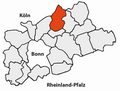 Rsk lohmar.png 1 200 × 906 ; 201 kio
-
 Rückseite des Bahnhofes Wahlscheid, Baudenkmal der Stadt Lohmar Nr. 46.jpg 4 309 × 2 999 ; 1,99 Mio
-
 Schild vom Bodendenkmal der Stadt Lohmar Nr 2 - Fliehburg Grünenborn.jpg 2 869 × 1 919 ; 515 kio
-
 Schloss Auel mit Teich am 29. April 2015.jpg 5 184 × 3 456 ; 2,35 Mio
-
 Schloss Auel von der Allee aus am 29. April 2015.jpg 5 092 × 3 395 ; 2,52 Mio
-
 Schürger auf der Museumsmeile des VVW in Wahlscheid am 15. Juli 2015.jpg 4 523 × 3 174 ; 1,42 Mio
-
 Siegelmarke Communalcasse Lohmar W0383449.jpg 268 × 270 ; 14 kio
-
 Steintisch vor den Fischteichen in Lohmar - Neuenhof.jpg 3 638 × 3 056 ; 7,23 Mio
-
 Turm der Kapelle von Lohmarhohn am 4. Juli 2015.jpg 4 756 × 3 372 ; 8,03 Mio
-
 WEEG - panoramio.jpg 3 264 × 2 448 ; 3,09 Mio
-
 Wegekreuz Gammersbacher Mühle versteckt in den Büschen.jpg 5 184 × 3 456 ; 10,02 Mio
-
 Wegekreuz in Lohmar - Hohn (fast zugewachsen).jpg 3 738 × 2 839 ; 975 kio
-
 Wegekreuz in Lohmar - Weeg - Inschrift.jpg 2 603 × 2 571 ; 4,46 Mio
-
 Wegekreuz in Lohmar - Weeg am 21. Januar 2013.JPG 5 184 × 3 456 ; 9,73 Mio
-
 Wegekreuz in Lohmar-Weeg.jpg 2 560 × 2 022 ; 973 kio
-
 Wegekreuz Schöpcherhof.jpg 4 193 × 3 408 ; 9,9 Mio
-
 Wegkreuz Lohmar Hauptstraße 2022-03-19.jpg 3 000 × 4 000 ; 4,96 Mio
-
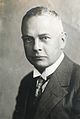 Wolfgang La Baume .jpg 1 954 × 2 908 ; 1,32 Mio
-
 Wundmal an den Füßen am Wegekreuz Rosauel.jpg 3 468 × 2 743 ; 679 kio
-
 Wundmale an der linken Hand vom Wegekreuz Rosauel.jpg 3 096 × 4 240 ; 1,04 Mio
-
 Wundmale an der rechten Hand vom Wegekreuz Rosauel.jpg 3 288 × 4 251 ; 1,15 Mio
-
 Zosterophyllum deciduum (fossil land plant) (Devonian; Lohmar-Breidt, Germany) (49081796348).jpg 2 345 × 1 737 ; 3,91 Mio

_-_geo-en.hlipp.de_-_11082.jpg)


_-_Lohmar_Nord_(1000_m)_-_geo.hlipp.de_-_6102.jpg)
_-_Lohmar_(1000_m)_-_geo.hlipp.de_-_6100.jpg)


.jpg)


_(Devonian;_Lohmar-Breidt,_Germany)_(49081796348).jpg)