Category:Long Wharf (Boston)
Zur Navigation springen
Zur Suche springen
Uferbauwerk in Boston  | |||||
| Medium hochladen | |||||
| Ist ein(e) | |||||
|---|---|---|---|---|---|
| Ist Teil von |
| ||||
| Ort | Boston, Suffolk County, Massachusetts | ||||
 | |||||
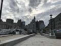
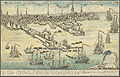
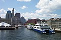
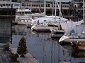
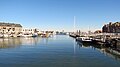
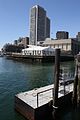
English: Long Wharf (Boston), located at 202 Atlantic Avenue at the base of State Street in Boston, Massachusetts, is a historic pier in Boston, Massachusetts built from 1710 to 1721, which once extended from State Street nearly a half-mile into Boston Harbor. Today, the much-shortened wharf – due to land fill on the city end – functions as a dock for passenger ferries and sightseeing boats. It is also the location of the Boston Marriott Long Wharf, the Gardiner Building (now a Chart House restaurant), the Custom House Block, and a viewing plaza at the end of the wharf. Long Wharf was designated a National Historic Landmark in 1996.
|
Diese Kategorie enthält Dateien zu einem Objekt, das im National Register of Historic Places der Vereinigten Staaten verzeichnet ist. Die Referenznummer lautet 66000768. |
Unterkategorien
Es werden 7 von insgesamt 7 Unterkategorien in dieser Kategorie angezeigt:
In Klammern die Anzahl der enthaltenen Kategorien (K), Seiten (S), Dateien (D)
A
B
- Boston Marriott Long Wharf (34 D)
C
- Custom House Block (Boston) (28 D)
G
- Gardiner Building (11 D)
L
- Long Wharf North (10 D)
- Long Wharf South (7 D)
Medien in der Kategorie „Long Wharf (Boston)“
Folgende 82 Dateien sind in dieser Kategorie, von 82 insgesamt.
-
 1731 Apthorp MerchantsRow BostonGazette Sept13.png 674 × 173; 122 KB
-
 1743 LongWharf Boston map WilliamPrice.png 827 × 719; 905 KB
-
 1789 BunchOfGrapes HeraldOfFreedom Boston March13.png 494 × 504; 262 KB
-
 1803 Tyler LongWharf Boston.png 718 × 521; 506 KB
-
 1857 plan StateStreetBlock Boston 2675836701.jpg 2.000 × 1.340; 1,63 MB
-
 1864 Hoxie LongWharf BostonDirectory.png 300 × 251; 29 KB
-
 1870 FinancialDistrict Boston map byFFuchs JohnWeik detail2.png 625 × 469; 534 KB
-
 1899 IndiaWharf LongWharf Boston map byAEDowns BPL.png 1.013 × 469; 1.016 KB
-
 1916 Felkin advert Long Wharf Boston USA.png 807 × 685; 381 KB
-
 2005 LongWharf snow Boston 16603940.jpg 640 × 480; 87 KB
-
 2010 LongWharf Boston 4618649719.jpg 4.032 × 2.689; 8 MB
-
 2010 LongWharf Boston.jpg 2.272 × 1.704; 3,78 MB
-
 2010 Wharf Boston 4619331472.jpg 2.936 × 3.966; 6,82 MB
-
 2017 Gardiner Building and Custom House Block, Long Wharf, Boston.jpg 4.430 × 1.701; 1,27 MB
-
 2017 Long Wharf, Boston, Massachusetts from Boston Harbor.jpg 4.608 × 2.068; 1,75 MB
-
 2351587680 LongWharf.jpg 1.500 × 864; 304 KB
-
 Aerial view, Boston Harbor, docks - DPLA - 10f951d8ad1b351eee854b79411c5f80.jpg 5.841 × 4.600; 3,66 MB
-
 Blue Line emergency exit on Long Wharf, March 2022.JPG 5.184 × 3.888; 9,55 MB
-
 Boston (48) (49338601611).jpg 4.032 × 3.024; 4,72 MB
-
 Boston (63) (49340072548).jpg 4.032 × 3.024; 4,95 MB
-
 Boston - panoramio (23).jpg 5.559 × 1.616; 1,2 MB
-
 Boston 1768 edit.jpeg 1.500 × 961; 634 KB
-
 Boston 1768.jpg 1.500 × 961; 584 KB
-
 Boston byNathanielDearborn MFABoston.png 792 × 459; 486 KB
-
 Boston ca1765 byJohnCarwitham.png 511 × 344; 391 KB
-
 Boston Custom House Tower View to the East.jpg 3.264 × 2.448; 1,8 MB
-
 Boston downtown view from the Long Wharf (4766291104).jpg 3.786 × 2.514; 3,4 MB
-
 Boston Harbor At Sundown (244400797).jpeg 2.048 × 1.361; 556 KB
-
 Boston Harbor City View.JPG 4.880 × 1.328; 2,25 MB
-
 Boston harbor skyline 2005.jpg 3.000 × 1.658; 932 KB
-
 Boston Harbor. - panoramio.jpg 7.323 × 2.468; 6,99 MB
-
 Boston Light 300th Anniversary 2853548.jpg 3.500 × 2.336; 2,78 MB
-
 Boston Long Wharf 1.JPG 2.160 × 1.440; 911 KB
-
 Boston Long Wharf 2.JPG 2.160 × 1.440; 691 KB
-
 Boston Long Wharf.JPG 2.160 × 1.440; 698 KB
-
 Boston Skyline (2742650935).jpg 3.047 × 2.285; 681 KB
-
 Boston Waterboat Marina Long Wharf Lobster Buoy Wall.jpg 2.560 × 1.920; 604 KB
-
 Boston Waterboat Marina Long Wharf.jpg 2.560 × 1.920; 264 KB
-
 Boston Waterfront Marina, Massachusetts (493568) (11061940493) (2).jpg 4.000 × 2.248; 2,03 MB
-

-
 Bronze Center paving Stone Compass Rose Long Wharf Boston.jpg 4.000 × 3.000; 2,51 MB
-
 Building on southerly corner of Long Wharf and Atlantic Avenue (13473315615).jpg 3.812 × 4.567; 2,42 MB
-
 Buildings on Long Wharf Numbers -9 and -11 (14518440691).jpg 3.831 × 4.731; 2,31 MB
-
 CrownCoffeeHouse Boston Drake1917.png 385 × 520; 81 KB
-
 Custom House Block 2024.jpg 4.032 × 3.024; 4,76 MB
-
 Embarcadero largo desde acuario - panoramio.jpg 4.000 × 2.664; 1,36 MB
-
 FultonIron LongWharf BostonDirectory 1850.png 313 × 501; 93 KB
-
 Gardiner Building 2023.jpg 4.032 × 3.024; 4,67 MB
-
 The Custom House Tower from Long Wharf, Arthur Clifton Goodwin.jpg 800 × 716; 123 KB
-
 Largo embarcadero de Boston - panoramio.jpg 4.000 × 2.664; 1,78 MB
-
 Lobster Buoy Wall Boston Waterboat Marina Long Wharf.jpg 1.920 × 2.560; 484 KB
-
 Long Wharf Custom house block.jpg 2.000 × 1.338; 870 KB
-
 Long Wharf historic pier Boston.jpg 1.920 × 2.560; 426 KB
-

-
 Long Wharf view, Boston Harbor, Logan Airport, Tug Boat.jpg 640 × 479; 173 KB
-
 Long Wharf, Central Wharf, and New England Aquarium, Boston, P1000075.JPG 5.472 × 3.648; 9,5 MB
-
 LongWharf Boston ca1900.png 392 × 455; 199 KB
-
 LongWharf ca1874 Boston byFolsom.png 498 × 251; 162 KB
-
 LongWharf&CHB.JPG 2.448 × 3.264; 2,59 MB
-
 Matthew J Hughes at Long Wharf, April 2013.jpg 5.184 × 3.456; 10,19 MB
-
 MEMNON Clipper ship sailing card 215819.jpg 383 × 600; 89 KB
-
 MiddlePassageMarker.jpg 3.120 × 4.160; 1,43 MB
-
 Old Boston taverns and tavern clubs (1917) (14598246168).jpg 1.632 × 2.276; 638 KB
-
 SE of Paving Stone Compass Rose Long Wharf Boston.jpg 1.175 × 2.555; 975 KB
-
 Shipping from Long Wharf Boston.jpg 1.071 × 1.082; 432 KB
-
 State Street - a brief account of a Boston way (1906) (14783172482).jpg 4.160 × 2.832; 1,97 MB
-
 State Street - a brief account of a Boston way (1906) (14783522265).jpg 4.064 × 2.742; 1,53 MB
-
 Stone Compass Rose Long Wharf Boston S.jpg 3.000 × 4.000; 2,02 MB
-
 Stone Compass Rose Long Wharf Boston.jpg 4.000 × 3.000; 1,07 MB
-

-
 The Harbor and waterfront, Boston, Mass., plate 09978.jpg 2.581 × 2.031; 2,23 MB
-
 Waterfront detail Boston map 1842.jpg 377 × 158; 72 KB
-
 Waterfront, Boston, MA, USA - panoramio (109).jpg 2.592 × 1.936; 1,73 MB
-
 Waterfront, Boston, MA, USA - panoramio (111).jpg 2.592 × 1.936; 3,17 MB
-
 Waterfront, Boston, MA, USA - panoramio (115).jpg 2.592 × 1.936; 1,84 MB
-
 Waterfront, Boston, MA, USA - panoramio (116).jpg 2.592 × 1.936; 1,75 MB
-
 Waterfront, Boston, MA, USA - panoramio (48).jpg 2.592 × 3.888; 3,55 MB
-
 Waterfront, Boston, MA, USA - panoramio (49).jpg 2.592 × 3.888; 3,84 MB
-
 Boston harbor and East Boston from State St. block, by Soule, John P., 1827-1904 2.jpg 2.737 × 1.369; 1,44 MB
-
 Long wharf and shipping, by J.W. & J.S. Moulton.jpg 2.625 × 1.492; 1,48 MB
-
 Long Wharf, from Robert N. Dennis collection of stereoscopic views.jpg 2.737 × 1.574; 1,54 MB
-
 Shipping from Long Wharf, from Robert N. Dennis collection of stereoscopic views.jpg 2.737 × 1.401; 1,52 MB


_(49338601611).jpg)
_(49340072548).jpg)


.jpg)
.jpeg)


.jpg)


_(11061940493)_(2).jpg)


.jpg)
.jpg)


_(14598246168).jpg)


_(14783172482).jpg)
_(14783522265).jpg)


_(14586429448).jpg)


.jpg)
.jpg)
.jpg)
.jpg)
.jpg)
.jpg)


.jpg)