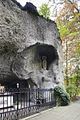
Category:Lourdesgrot, Sint Nicolaasga
Naar navigatie springen
Naar zoeken springen
| Objectlocatie | | Bekijk alle coördinaten: OpenStreetMap |
|---|
Sint Nicolaasga  | |||||
| Media uploaden | |||||
| Is een | |||||
|---|---|---|---|---|---|
| Opgedragen aan | |||||
| Locatie | Sint Nicolaasga, De Friese Meren, Friesland, Nederland | ||||
| Erfgoedstatus |
| ||||
 | |||||
|
Dit is een categorie van een rijksmonument met nummer 514069
|
| Adres |
|
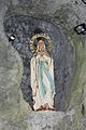
Media in categorie "Lourdesgrot, Sint Nicolaasga"
Deze categorie bevat de volgende 14 bestanden, van in totaal 14.
-

-
 Lourdesgrot Sint Nicolaasga 01.JPG 576 × 768; 108 kB
-
-
 Sint nicolaas-lourdesgrot-1.JPG 2.048 × 1.536; 847 kB
-
 Sint nicolaas-lourdesgrot-2.JPG 2.048 × 1.536; 757 kB
-

-

-

-

-

-
-

-

-


