Category:Maps of Austrasia
Vai alla navigazione
Vai alla ricerca
regione storica del regno dei Franchi  | |||||
| Carica un file multimediale | |||||
| Istanza di | |||||
|---|---|---|---|---|---|
| Data di fondazione o creazione |
| ||||
| Data di scioglimento o demolizione |
| ||||
| Distinto da | |||||
| |||||
File nella categoria "Maps of Austrasia"
Questa categoria contiene 17 file, indicati di seguito, su un totale di 17.
-
 Austrasie752.jpg 484 × 689; 78 KB
-

-
 Austrasie - btv1b8495009t.jpg 6 448 × 8 122; 7,29 MB
-

-
 ClovisDomain japref.jpg 543 × 335; 79 KB
-
 Francia 714.png 1 252 × 1 240; 520 KB
-
 Francia at the death of Pepin of Heristal 714-nl.svg 1 996 × 1 789; 2,04 MB
-
 Frankish Empire 481 to 814-en.svg 1 591 × 1 205; 834 KB
-
 Frankish Empire 481 to 814-es.svg 1 851 × 1 309; 1,08 MB
-
 Frankish Empire 481 to 814-fr.svg 1 739 × 1 233; 296 KB
-
 Hettergouw.jpg 1 181 × 1 144; 200 KB
-

-

-
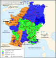 Le royaume des Francs en 567.svg 756 × 785; 207 KB
-
 Map of Austrasia - 587 (cropped).jpg 648 × 617; 138 KB
-
 Merovingian dynasty.jpg 838 × 773; 78 KB
-
 Spruner-Menke Handatlas 1880 Karte 32.jpg 10 465 × 8 593; 16,66 MB

.jpg)


.jpg)


Categorie:
- Maps of the Frankish territory
- Maps of the history of Europe by former country
- Maps of the Merovingian territory
- Maps of the history of France
- Maps of the history of the Netherlands
- Maps of the history of Belgium
- Maps of the history of Luxembourg
- Maps of the history of Germany by historic territory
- Maps of the history of North Rhine-Westphalia
- 511 establishments
- 751 disestablishments in Europe