Category:Marston Montgomery
Vai alla navigazione
Vai alla ricerca
village and civil parish in Derbyshire Dales district, Derbyshire, England  | |||||
| Carica un file multimediale | |||||
| Istanza di | |||||
|---|---|---|---|---|---|
| Luogo | Derbyshire Dales, Derbyshire, Midlands Orientali, Inghilterra | ||||
 | |||||
Sottocategorie
Questa categoria contiene le 4 sottocategorie indicate di seguito, su un totale di 4.
File nella categoria "Marston Montgomery"
Questa categoria contiene 123 file, indicati di seguito, su un totale di 123.
-
 A Country Lane near Thurvaston - geograph.org.uk - 2948595.jpg 640 × 425; 112 KB
-
-
 A very soft and wet footpath - geograph.org.uk - 379442.jpg 640 × 480; 110 KB
-
 Across the fields - geograph.org.uk - 5408012.jpg 4 896 × 3 672; 6,84 MB
-
 Bamford deep well pump - geograph.org.uk - 5405367.jpg 2 636 × 2 964; 816 KB
-
 Bank erosion by the River Dove - geograph.org.uk - 3927593.jpg 3 872 × 2 592; 4,76 MB
-
 Banktop Farm on Somersal Lane - geograph.org.uk - 2948677.jpg 640 × 425; 74 KB
-
 Banktop Farm, Marston Montgomery - geograph.org.uk - 5093427.jpg 640 × 480; 60 KB
-
 Bowling Alley Lane - geograph.org.uk - 3769170.jpg 2 256 × 1 504; 2,59 MB
-
 Bowling Alley Lane - geograph.org.uk - 5093433.jpg 640 × 480; 65 KB
-
 Bridleway at Potter Somersal - geograph.org.uk - 200489.jpg 480 × 640; 101 KB
-
 Bridleway towards Abbotsholme School - geograph.org.uk - 4072267.jpg 640 × 480; 102 KB
-
 Broad Lane - geograph.org.uk - 379459.jpg 640 × 480; 90 KB
-
 Celandines - geograph.org.uk - 380906.jpg 640 × 480; 107 KB
-
 Churchyard with Copper Beech - geograph.org.uk - 5454425.jpg 4 896 × 3 672; 7,24 MB
-
 Cottages on Barway - geograph.org.uk - 5845480.jpg 2 027 × 1 520; 951 KB
-
 Crop Field near Hurd's Barn - geograph.org.uk - 4145143.jpg 4 000 × 3 000; 2,21 MB
-
 Cubley Lane - geograph.org.uk - 4072270.jpg 640 × 480; 96 KB
-
 Cubley Lane - geograph.org.uk - 4072274.jpg 640 × 480; 99 KB
-
 Cubley Lane - geograph.org.uk - 4072278.jpg 640 × 480; 110 KB
-
 Cyclist on Cubley lane - geograph.org.uk - 4154872.jpg 4 000 × 3 000; 2,48 MB
-
 Daisybank Farm, Marston Montgomery.jpg 1 387 × 1 040; 412 KB
-
 Dead mole in the middle of the road - geograph.org.uk - 4457930.jpg 2 878 × 2 160; 4,07 MB
-
 Derbyshire UK parish map highlighting Marston Montgomery.svg 888 × 1 308; 2,34 MB
-
 Dove House, Marston Montgomery.jpg 4 896 × 3 672; 7,14 MB
-
 Driveway to Shaw Lane Farm - geograph.org.uk - 2948630.jpg 640 × 425; 78 KB
-
 Entering Marston Montgomery - geograph.org.uk - 5093411.jpg 640 × 480; 66 KB
-
 Entrance to Waldley house - geograph.org.uk - 3769036.jpg 2 256 × 1 504; 2,44 MB
-
 Farm track (footpath) off Riggs Lane - geograph.org.uk - 5093399.jpg 640 × 480; 91 KB
-
 Farmland by Marston Lodge - geograph.org.uk - 4145137.jpg 4 000 × 3 000; 2,51 MB
-
 Farmland near Marston Montgomery - geograph.org.uk - 432320.jpg 640 × 428; 108 KB
-
 Farmland near White House - geograph.org.uk - 4072262.jpg 640 × 480; 68 KB
-
 Farmland north of Cubley Lane - geograph.org.uk - 4072277.jpg 640 × 480; 62 KB
-
 Farmland, Marston Montgomery - geograph.org.uk - 4072272.jpg 640 × 480; 94 KB
-
 Feeding bins in a grass paddock - geograph.org.uk - 2943889.jpg 640 × 425; 75 KB
-
 Field entrance off Hollyhurst Lane - geograph.org.uk - 5093382.jpg 640 × 480; 74 KB
-
 Field entrance, Riggslane - geograph.org.uk - 5093397.jpg 640 × 480; 69 KB
-

-
 Footpath and Grassland near Malcolmsley - geograph.org.uk - 4154833.jpg 4 000 × 3 000; 2,37 MB
-
 Footpath and Parish Boundary - geograph.org.uk - 380989.jpg 640 × 480; 85 KB
-
 Footpath near Marston Woodhouse - geograph.org.uk - 3939389.jpg 3 862 × 2 806; 1,9 MB
-
 Footpath off Cubley Lane - geograph.org.uk - 4072275.jpg 640 × 480; 79 KB
-
 Footpath to Havenfield Farm - geograph.org.uk - 5408011.jpg 4 896 × 3 672; 6,43 MB
-
 Footpath to Long Chimneys - geograph.org.uk - 380916.jpg 640 × 480; 65 KB
-
 Footpath to Mountpleasent Farm - geograph.org.uk - 2948581.jpg 640 × 425; 132 KB
-
 Grassland near Rocester - geograph.org.uk - 4144605.jpg 4 000 × 3 000; 3,08 MB
-
 Grazing Land near The Shawleys - geograph.org.uk - 4145139.jpg 4 000 × 3 000; 2,24 MB
-
 Grazing near Marston Montgomery - geograph.org.uk - 5093406.jpg 640 × 480; 62 KB
-
 Grazing towards Banktop Farm - geograph.org.uk - 5093428.jpg 640 × 480; 66 KB
-
 Grazing, Marstonbank Farm - geograph.org.uk - 4072269.jpg 640 × 480; 79 KB
-
 Grazing, Riggslane - geograph.org.uk - 5093393.jpg 640 × 480; 76 KB
-
 Heading for Daisy Bank Farm - geograph.org.uk - 2943935.jpg 640 × 425; 66 KB
-
 Heading south on Bowling Alley Lane - geograph.org.uk - 5093435.jpg 640 × 480; 89 KB
-
 Hollyhurst Lane - geograph.org.uk - 3769183.jpg 2 256 × 1 504; 2,98 MB
-
 Hollyhurst Lane - geograph.org.uk - 3770348.jpg 2 256 × 1 504; 2,59 MB
-
 Hollyhurst Lane - geograph.org.uk - 5093386.jpg 640 × 480; 65 KB
-
 Hollyhurst Lane - geograph.org.uk - 5093390.jpg 640 × 480; 73 KB
-
 Holme Lea Entrance - geograph.org.uk - 366095.jpg 640 × 480; 101 KB
-
 Horse Paddocks at Morry House Farm - geograph.org.uk - 2943902.jpg 640 × 425; 84 KB
-
 House on the hill - geograph.org.uk - 5408013.jpg 4 896 × 3 672; 6,65 MB
-
 Large house at Marstonbank Farm - geograph.org.uk - 5845485.jpg 1 437 × 1 078; 625 KB
-

-
 Lush Grassland near Marston Montgomery - geograph.org.uk - 3939414.jpg 4 000 × 3 000; 3,21 MB
-
 Maize field, Potter Somersal - geograph.org.uk - 200488.jpg 640 × 480; 77 KB
-
 Marston Montgomery - geograph.org.uk - 4458040.jpg 4 320 × 3 240; 3,06 MB
-
 Marston Montgomery - geograph.org.uk - 5405332.jpg 4 896 × 3 672; 6,7 MB
-
 Marston Park farm near Rocester - geograph.org.uk - 470180.jpg 640 × 427; 125 KB
-
 Marston Woodhouse Farm - geograph.org.uk - 5093432.jpg 640 × 426; 46 KB
-
 Marstonbank Farm - geograph.org.uk - 4072268.jpg 640 × 478; 55 KB
-
 Minor road towards Thurvaston - geograph.org.uk - 4072264.jpg 640 × 480; 94 KB
-
 Minor road towards Thurvaston - geograph.org.uk - 4539449.jpg 640 × 480; 71 KB
-
 Mountpleasant Farm - geograph.org.uk - 366073.jpg 640 × 480; 91 KB
-
 Near to Marston Woodhouse - geograph.org.uk - 4457936.jpg 4 320 × 3 240; 6,75 MB
-
 Oilseed rape crop - geograph.org.uk - 4072265.jpg 640 × 480; 76 KB
-
 Pasture near Cubley Lane - geograph.org.uk - 4145131.jpg 4 000 × 3 000; 2,45 MB
-
 Ploughed Field near North Fields Farm - geograph.org.uk - 3938905.jpg 3 992 × 2 990; 2,41 MB
-
 Public Footpath off Riggs Lane - geograph.org.uk - 3768154.jpg 2 256 × 1 504; 2,58 MB
-
 Public footpath to Marston Bank Farm - geograph.org.uk - 2943912.jpg 640 × 425; 122 KB
-
 Public footpath with a fallen tree - geograph.org.uk - 380900.jpg 640 × 480; 113 KB
-
 Pump house next to path to church - geograph.org.uk - 5405378.jpg 4 896 × 3 672; 6,44 MB
-
 Pump in shadows - geograph.org.uk - 5405618.jpg 4 896 × 3 672; 6,55 MB
-

-

-
 Redbrick barn at Banktop Farm - geograph.org.uk - 5845453.jpg 1 348 × 970; 409 KB
-
 Riding into Marston Montgomery - geograph.org.uk - 5845462.jpg 1 469 × 1 102; 556 KB
-
 Riding north on Bowling Alley Lane - geograph.org.uk - 5845442.jpg 1 469 × 1 102; 701 KB
-
 Riding through Marston Montgomery - geograph.org.uk - 5845464.jpg 1 632 × 1 224; 464 KB
-
 Riggs Lane - geograph.org.uk - 5093403.jpg 640 × 480; 52 KB
-
 Riggs Lane - geograph.org.uk - 5093409.jpg 640 × 480; 62 KB
-
 River Dove Near Rocester Bridge - geograph.org.uk - 3764760.jpg 1 496 × 1 122; 838 KB
-

-
 Road junction, Marston Montgomery - geograph.org.uk - 1912158.jpg 2 000 × 1 478; 508 KB
-
 Road name - geograph.org.uk - 5454417.jpg 4 896 × 3 672; 6,75 MB
-
 Road to Malcolmsley Farm - geograph.org.uk - 5093388.jpg 640 × 480; 59 KB
-
 Royal Jubilee Plaques - geograph.org.uk - 5405349.jpg 4 896 × 3 672; 6,62 MB
-
 Shaw Lane Farm - geograph.org.uk - 380909.jpg 640 × 480; 103 KB
-
 Shaw Lane near Marston Montgomery - geograph.org.uk - 4154859.jpg 4 000 × 3 000; 2,72 MB
-
 Telephone box, Marston Montgomery - geograph.org.uk - 5093418.jpg 640 × 480; 69 KB
-
 The Beeches, Waldley - geograph.org.uk - 3939506.jpg 3 972 × 2 964; 2,11 MB
-
 The Entrance to Woodhay Farm - geograph.org.uk - 2947163.jpg 640 × 425; 103 KB
-
 The Fingerpost without a Stile - geograph.org.uk - 2948606.jpg 640 × 425; 113 KB
-
 The lane called "Barway" - geograph.org.uk - 5408009.jpg 4 896 × 3 672; 7,14 MB
-

-
 The village pub - geograph.org.uk - 5454418.jpg 4 896 × 3 672; 6,56 MB
-
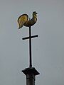 The Weathercock - geograph.org.uk - 5405398.jpg 3 672 × 4 896; 658 KB
-
 Track and path to Marston Park - geograph.org.uk - 380992.jpg 640 × 480; 84 KB
-
 Track to Marston Lodge - geograph.org.uk - 4145135.jpg 3 896 × 2 846; 2,21 MB
-
 Track to Marston Park - geograph.org.uk - 4072273.jpg 640 × 480; 77 KB
-
 Tractor and Barn near Thurvaston - geograph.org.uk - 2948555.jpg 640 × 425; 121 KB
-
 Trees and manure - geograph.org.uk - 380902.jpg 640 × 480; 109 KB
-
 Under the Copper Beech - geograph.org.uk - 5454426.jpg 4 896 × 3 672; 6,65 MB
-
 Unmown and mown - geograph.org.uk - 470181.jpg 640 × 419; 106 KB
-
 Unused Footpath - geograph.org.uk - 380913.jpg 640 × 480; 113 KB
-
 Village pump - geograph.org.uk - 5405340.jpg 4 896 × 3 672; 7,2 MB
-
 Village pump - geograph.org.uk - 5405351.jpg 3 672 × 4 896; 2,43 MB
-
 Village pump, Marston Montgomery - geograph.org.uk - 200480.jpg 640 × 480; 96 KB
-
 Wood Hay Farm - geograph.org.uk - 4534431.jpg 640 × 480; 48 KB
-
 Woodhay Farm - geograph.org.uk - 380919.jpg 640 × 480; 69 KB
-
 Cottages near Marston Montgomery - geograph.org.uk - 200481.jpg 640 × 480; 70 KB
-
 Marston Bank Farm - geograph.org.uk - 200472.jpg 640 × 480; 79 KB
-
 Marston Woodhouse - geograph.org.uk - 200477.jpg 640 × 480; 73 KB
-
 Somersal House - geograph.org.uk - 200486.jpg 640 × 480; 76 KB
-
 Somersal Lodge - geograph.org.uk - 200487.jpg 640 × 480; 65 KB


_off_Riggs_Lane_-_geograph.org.uk_-_5093399.jpg)


