Category:Marzling
Vai alla navigazione
Vai alla ricerca

municipality of Germany    | |||||
| Carica un file multimediale | |||||
| Audio della pronuncia | |||||
|---|---|---|---|---|---|
| Istanza di |
| ||||
| Parte di |
| ||||
| Luogo | circondario di Frisinga, Alta Baviera, Baviera, Germania | ||||
| Capo del governo |
| ||||
| Popolazione |
| ||||
| Superficie |
| ||||
| Altezza sul mare |
| ||||
| sito web ufficiale | |||||
 | |||||
Sottocategorie
Questa categoria contiene le 12 sottocategorie indicate di seguito, su un totale di 12.
B
- Badesee Stoibermühle (19 F)
C
- Coats of arms of Marzling (1 F)
M
- Maps of Marzling (2 F)
N
- Nature of Marzling (44 F)
R
- Rail transport in Marzling (4 F)
V
- Views of Marzling (3 F)
W
- Wayside Crosses in Marzling (17 F)
File nella categoria "Marzling"
Questa categoria contiene 11 file, indicati di seguito, su un totale di 11.
-
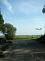 Attaching nach Schwaig 1.JPG 2 736 × 3 648; 5,79 MB
-
 Attaching nach Schwaig 2.JPG 2 736 × 3 648; 5,49 MB
-
 DOP40 - Landkreis Freising 32706 5365 (Bayerische Vermessungsverwaltung).tif 2 500 × 2 500; 16,66 MB
-
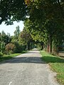
 Ehemalige Straße von Freising nach Erding bei Attaching 03.jpg 4 624 × 3 472; 7,13 MB
-
 Ehemalige Straße von Freising nach Erding bei Attaching 01.jpg 3 072 × 4 096; 7,41 MB
-
 Ehemalige Straße von Freising nach Erding bei Attaching 02.jpg 3 072 × 4 096; 9,05 MB
-
 Kiesbagger.jpg 10 290 × 2 932; 4,53 MB
-
 Marzling (Jan. 2021).jpg 5 184 × 3 888; 9,2 MB
-
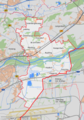 Marzling.png 3 679 × 5 233; 3,59 MB
-
 Straße bei Attaching.jpg 4 096 × 3 072; 6,86 MB
-
 Taubenhaus Marzling.jpg 3 888 × 5 184; 5,92 MB


.jpg)


