Category:Mataura River
Zur Navigation springen
Zur Suche springen
Fluss in Neuseeland   | |||||
| Medium hochladen | |||||
| Ist ein(e) | |||||
|---|---|---|---|---|---|
| Ort |
| ||||
| Länge |
| ||||
| Höhe über dem Meeresspiegel |
| ||||
| Mündet in |
| ||||
| Verschieden von | |||||
 | |||||
Medien in der Kategorie „Mataura River“
Folgende 10 Dateien sind in dieser Kategorie, von 10 insgesamt.
-
 Gore banner River.jpg 4.200 × 600; 304 KB
-
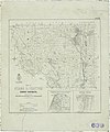
 Map of Wyndham Survey District, also Part of the Districts of Mokoreta and Slopedown.jpg 5.341 × 4.054; 5,38 MB
-
 Mataura Paper Mill, New Zealand.jpg 692 × 277; 90 KB
-
 NZ-Mataura R.png 1.234 × 1.395; 255 KB
-
 Oteramika Hundred.jpg 3.778 × 4.772; 6,44 MB
-
 Plan of Otama and Chatton Survey Districts.jpg 3.915 × 4.700; 4,73 MB
-
 Plan of the Edendale Settlement - Lindhurst, Lothian, Mataura and Oteramika Hundreds.jpg 3.402 × 4.994; 3,96 MB
-
 SD 55 - Waimumu Hundred and Part of Hokonui District.jpg 4.708 × 3.428; 4,49 MB
-
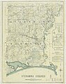
 Toetoes Survey District.jpg 3.492 × 3.660; 4,32 MB
-
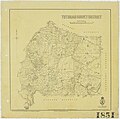 Tuturau Survey District.jpg 3.619 × 3.583; 3,58 MB


