Category:Minchinhampton
Aller à la navigation
Aller à la recherche
localité britannique du comté anglais de Gloucestershire  | |||||
| Téléverser des médias | |||||
| Nature de l’élément | |||||
|---|---|---|---|---|---|
| Lieu | Stroud, Gloucestershire, Angleterre du Sud-Ouest, Angleterre | ||||
| Réputé identique à | Minchinhampton (page en doublon, paroisse civile) | ||||
| site officiel | |||||
 | |||||
Sous-catégories
Cette catégorie comprend 8 sous-catégories, dont les 8 ci-dessous.
B
- Ball's Green (2 F)
C
- Cirencester Road (9 F)
G
- Gatcombe Park (2 F)
H
L
- Long Stone, Minchinhampton (3 F)
M
- Minchinhampton Market House (11 F)
R
W
Média dans la catégorie « Minchinhampton »
Cette catégorie comprend 651 fichiers, dont les 200 ci-dessous.
(page précédente) (page suivante)-

-
 20 is plenty in Minchinhampton - geograph.org.uk - 4857540.jpg 800 × 611 ; 132 kio
-
 40 on Culver Hill, Amberley - geograph.org.uk - 5760100.jpg 800 × 799 ; 132 kio
-
 40 on Minchinhampton Common - geograph.org.uk - 4705554.jpg 800 × 663 ; 144 kio
-

-
 6 Squadron AFC SE5 aircraft.jpg 450 × 230 ; 50 kio
-
 A lone tree, Minchinhampton Common - geograph.org.uk - 5857139.jpg 1 600 × 800 ; 448 kio
-
 A viaduct over the River Frome by Bourne Mills - geograph.org.uk - 1600047.jpg 640 × 427 ; 115 kio
-
 Abandoned digger, Minchinhampton - geograph.org.uk - 2022188.jpg 640 × 481 ; 77 kio
-
 Above the Golden Valley - geograph.org.uk - 2846005.jpg 1 024 × 680 ; 180 kio
-
 Across the Common - Box, Gloucestershire - geograph.org.uk - 6090899.jpg 1 024 × 622 ; 90 kio
-
 Allotments entrance gate, Minchinhampton - geograph.org.uk - 5135572.jpg 800 × 525 ; 96 kio
-

-
 Amberley - geograph.org.uk - 3499577.jpg 3 648 × 2 736 ; 4,85 Mio
-
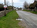
 Amberley boundary sign alongside Culver Hill - geograph.org.uk - 5760079.jpg 800 × 591 ; 148 kio
-
 Amberley Common - geograph.org.uk - 6230128.jpg 4 032 × 3 024 ; 2,79 Mio
-
 Amberley Cow Hunt 2018 banner in Amberley - geograph.org.uk - 5747608.jpg 738 × 800 ; 303 kio
-
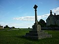
 Amberley Cross (War Memorial) - geograph.org.uk - 4733370.jpg 3 648 × 2 736 ; 3,51 Mio
-
 Amberley houses, Gloucestershire - geograph.org.uk - 5748662.jpg 800 × 687 ; 117 kio
-
 Amberley Inn - geograph.org.uk - 5663472.jpg 1 600 × 1 041 ; 273 kio
-
 Amberley Inn bus shelter, Amberley - geograph.org.uk - 5766252.jpg 800 × 600 ; 155 kio
-
 Amberley Inn electricity substation, Amberley - geograph.org.uk - 5748643.jpg 800 × 622 ; 159 kio
-
 Amberley Inn name sign, Amberley - geograph.org.uk - 5766210.jpg 555 × 640 ; 91 kio
-
 Amberley Inn, Culver Hill, Amberley - geograph.org.uk - 5766206.jpg 800 × 610 ; 108 kio
-
 Amberley Parochial School, Amberley - geograph.org.uk - 5747536.jpg 800 × 579 ; 120 kio
-
-
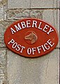
 Amberley Post Office, Gloucestershire - geograph.org.uk - 5748668.jpg 800 × 620 ; 118 kio
-
 Amberley Ridge, Houndscroft - geograph.org.uk - 4738878.jpg 800 × 607 ; 117 kio
-
 Amberley village school fete - geograph.org.uk - 3519490.jpg 800 × 451 ; 208 kio
-
 Amberley War Memorial - geograph.org.uk - 3499554.jpg 3 648 × 2 736 ; 4,11 Mio
-
 Amberley, Marling Close - geograph.org.uk - 4733398.jpg 3 648 × 2 736 ; 3,23 Mio
-
 Amberley, north - geograph.org.uk - 4733424.jpg 3 648 × 2 736 ; 4,55 Mio
-
 Ambrose House, Brimscombe - geograph.org.uk - 4688219.jpg 800 × 600 ; 142 kio
-
 Animal welfare charities' stands at Gatcombe Park - geograph.org.uk - 5884772.jpg 4 032 × 3 024 ; 3,73 Mio
-
 Antique Clocks business, Inchbrook - geograph.org.uk - 4785774.jpg 800 × 658 ; 137 kio
-
 Approaching Burleigh - geograph.org.uk - 1955316.jpg 640 × 480 ; 53 kio
-
 Approaching Minchinhampton from the west - geograph.org.uk - 3519421.jpg 800 × 451 ; 193 kio
-
 Arable field near Peaches Farm - geograph.org.uk - 5200474.jpg 800 × 600 ; 176 kio
-
 Aston Down airfield - geograph.org.uk - 5095698.jpg 4 000 × 3 000 ; 4,69 Mio
-
 Aston Down Airfield, aerial 2019 - geograph.org.uk - 6238376.jpg 800 × 533 ; 87 kio
-
 Auto Bodytech, Inchbrook - geograph.org.uk - 4785683.jpg 800 × 600 ; 105 kio
-
-

-
 Autumn colours, Rodborough Common - geograph.org.uk - 4705313.jpg 800 × 705 ; 186 kio
-
 Autumn on Brimscombe Hill - geograph.org.uk - 962537.jpg 640 × 480 ; 93 kio
-
 Avening, sheep grazing - geograph.org.uk - 2308971.jpg 1 024 × 768 ; 176 kio
-
 Bath Road towards Nailsworth - geograph.org.uk - 4731031.jpg 800 × 642 ; 135 kio
-
 Bath Road, South Woodchester - geograph.org.uk - 4774314.jpg 800 × 624 ; 119 kio
-
 Bell Cottage and The Bell, Burleigh - geograph.org.uk - 4718140.jpg 800 × 673 ; 149 kio
-
 Bell Lane, Minchinhampton - geograph.org.uk - 5495022.jpg 800 × 600 ; 134 kio
-
 Bench alongside a bus stop, Amberley - geograph.org.uk - 5766258.jpg 800 × 626 ; 137 kio
-
 Besbury Common - geograph.org.uk - 1660249.jpg 583 × 640 ; 168 kio
-
 Besbury Farm viewed from Upper Bourne - geograph.org.uk - 2473931.jpg 1 000 × 887 ; 219 kio
-
 Besbury Park houses, Minchinhampton - geograph.org.uk - 5059119.jpg 800 × 482 ; 82 kio
-

-

-
 Boots Pharmacy, Minchinhampton - geograph.org.uk - 4989036.jpg 800 × 686 ; 117 kio
-
 Bourne Mill, Brimscombe - geograph.org.uk - 3935180.jpg 4 320 × 3 240 ; 4,01 Mio
-
 Bownham Mead, Rodborough Common - geograph.org.uk - 4705424.jpg 800 × 543 ; 143 kio
-
 Bownham School electricity substation, Bownham - geograph.org.uk - 4705454.jpg 800 × 635 ; 205 kio
-
 Bridge on the Thames and Severn Canal - geograph.org.uk - 4963478.jpg 800 × 600 ; 193 kio
-
 Bridge over the Thames and Severn Canal - geograph.org.uk - 4814472.jpg 800 × 531 ; 162 kio
-
 Bridge over the Thames and Severn Canal - geograph.org.uk - 4963474.jpg 800 × 600 ; 175 kio
-
 Bridge over the Thames and Severn Canal - geograph.org.uk - 4963540.jpg 1 024 × 768 ; 449 kio
-
 Brimscombe Farm, Brimscombe - geograph.org.uk - 4662113.jpg 800 × 621 ; 113 kio
-
 Brimscombe Hill bus stop, Brimscombe - geograph.org.uk - 4691749.jpg 800 × 562 ; 117 kio
-
 Brimscombe Hill, Brimscombe - geograph.org.uk - 4688172.jpg 800 × 775 ; 216 kio
-
 Brimscombe Methodist Church, Brimscombe - geograph.org.uk - 4661135.jpg 800 × 517 ; 124 kio
-
 Brimscombe St Mary's level crossing, from the north - geograph.org.uk - 4894695.jpg 1 024 × 768 ; 162 kio
-
 Brimscombe St Mary's level crossing, open for cars - geograph.org.uk - 4894693.jpg 1 024 × 768 ; 137 kio
-
 Brookes Hair ^ Beauty in Minchinhampton - geograph.org.uk - 4989008.jpg 800 × 600 ; 109 kio
-
 Burleigh - Please drive carefully - geograph.org.uk - 4722262.jpg 800 × 778 ; 172 kio
-
 Burleigh boundary sign - geograph.org.uk - 4717749.jpg 800 × 588 ; 218 kio
-
 Burleigh bus stop and bench - geograph.org.uk - 4722270.jpg 702 × 800 ; 162 kio
-
 Burleigh Corner House, Burleigh - geograph.org.uk - 4722295.jpg 800 × 513 ; 142 kio
-

-
 Burleigh Lane, Burleigh - geograph.org.uk - 4722245.jpg 800 × 698 ; 178 kio
-

-
 Bus shelter in Hampton Fields - geograph.org.uk - 5862219.jpg 4 268 × 2 370 ; 2,9 Mio
-
 Bus shelter near Minchinhampton Common - geograph.org.uk - 4856252.jpg 800 × 532 ; 107 kio
-
 Bus stop and shelter near Amberley War Memorial - geograph.org.uk - 5766308.jpg 800 × 587 ; 135 kio
-
 Buses in the Square - geograph.org.uk - 1941124.jpg 1 024 × 768 ; 153 kio
-

-
 Butterrow Hill on Rodborough Common - geograph.org.uk - 2294292.jpg 1 500 × 1 000 ; 187 kio
-
 Byway near Aston Down airfield - geograph.org.uk - 5095682.jpg 4 000 × 3 000 ; 4,56 Mio
-
 Byway past Devil's Churchyard - geograph.org.uk - 5095723.jpg 4 000 × 3 000 ; 4,62 Mio
-
 C R Hollands industrial supplies, Woodchester - geograph.org.uk - 4774287.jpg 800 × 565 ; 159 kio
-
 Campsite this way, Minchinhampton - geograph.org.uk - 4856803.jpg 800 × 676 ; 158 kio
-
 Cattle crossing^ - geograph.org.uk - 2060446.jpg 640 × 480 ; 45 kio
-
 Cattle grid across Brimscombe Hill, Burleigh - geograph.org.uk - 4717796.jpg 800 × 600 ; 139 kio
-

-
 Cattle grid at Minchinhampton - geograph.org.uk - 2915028.jpg 1 024 × 680 ; 219 kio
-

-
 Cattle grid in Woefuldane Bottom, Minchinhampton - geograph.org.uk - 5862193.jpg 1 600 × 1 143 ; 758 kio
-

-
 Cattle on Minchinhampton Common - geograph.org.uk - 2060437.jpg 640 × 480 ; 52 kio
-
 Chapel Lane Cottage, Minchinhampton - geograph.org.uk - 5152515.jpg 600 × 800 ; 126 kio
-
 Chapel Lane, Minchinhampton - geograph.org.uk - 5148899.jpg 800 × 799 ; 211 kio
-
 Chapel Lane, Minchinhampton - geograph.org.uk - 6117911.jpg 4 608 × 2 592 ; 5,87 Mio
-
 Church over the suburban roof-tops - geograph.org.uk - 14241.jpg 640 × 480 ; 114 kio
-
 Claycombe from Brimscombe Hill - geograph.org.uk - 5762216.jpg 4 608 × 3 456 ; 4,74 Mio
-
 Common at Minchinhampton - geograph.org.uk - 6407344.jpg 1 200 × 803 ; 893 kio
-

-

-

-
 Cotswold drystone wall near Minchinhampton - geograph.org.uk - 4853356.jpg 800 × 533 ; 107 kio
-
 Cotswold House, Minchinhampton - geograph.org.uk - 5034839.jpg 800 × 609 ; 118 kio
-
 Cottages, Minchinhampton - geograph.org.uk - 2022263.jpg 640 × 480 ; 76 kio
-
 Country lane near Box - geograph.org.uk - 6117918.jpg 4 608 × 2 592 ; 6,68 Mio
-
 Crackstone Stables - geograph.org.uk - 5095734.jpg 4 000 × 3 000 ; 4,46 Mio
-
 Cross-country course in Gatcombe Park - geograph.org.uk - 5944075.jpg 4 032 × 3 024 ; 4,39 Mio
-
 Cross-country fences at Gatcombe Park - geograph.org.uk - 5884760.jpg 3 319 × 2 507 ; 4,02 Mio
-
 Crossroads in the centre of Minchinhampton - geograph.org.uk - 4989073.jpg 711 × 800 ; 127 kio
-
 Crossroads, Minchinhampton - geograph.org.uk - 532094.jpg 640 × 480 ; 132 kio
-
 Crown Inn, Minchinhampton - geograph.org.uk - 4853236.jpg 800 × 600 ; 119 kio
-

-
 Culver Hill - geograph.org.uk - 4267548.jpg 640 × 480 ; 74 kio
-
 Culver Hill - geograph.org.uk - 4267552.jpg 640 × 480 ; 58 kio
-
 Culver Hill direction sign near Woodchester - geograph.org.uk - 4731024.jpg 800 × 644 ; 197 kio
-

-
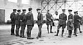 D00427BirdwoodWattPhillippsHolden1919.jpg 640 × 353 ; 148 kio
-
 D00432PhillippsBirdwood1919.jpg 425 × 222 ; 30 kio
-

-
 Diamond Jubilee memorial - geograph.org.uk - 6230123.jpg 3 024 × 4 032 ; 4,86 Mio
-

-
 Distinctive number 18A West End, Minchinhampton - geograph.org.uk - 5002104.jpg 679 × 800 ; 133 kio
-

-
 Disused mine, Iron Mills Common - geograph.org.uk - 6112528.jpg 3 000 × 1 688 ; 5,46 Mio
-
 Disused Thames and Severn Canal - geograph.org.uk - 4963513.jpg 1 024 × 768 ; 409 kio
-

-
 Dr Brown's Road - geograph.org.uk - 5178463.jpg 1 024 × 768 ; 309 kio
-

-

-
 Eastern boundary of Minchinhampton - geograph.org.uk - 5059045.jpg 800 × 577 ; 124 kio
-
 Eastern end of Cuckoo Row, Minchinhampton - geograph.org.uk - 5035362.jpg 800 × 658 ; 191 kio
-
 Eastern end of West End, Minchinhampton - geograph.org.uk - 4989156.jpg 694 × 800 ; 131 kio
-
 Eastwards view - Box, Gloucestershire - geograph.org.uk - 6256211.jpg 1 024 × 628 ; 95 kio
-
 Edge of Minchinhampton Common - geograph.org.uk - 5779471.jpg 2 048 × 1 536 ; 1,3 Mio
-
 Edwardian Rock House, Brimscombe - geograph.org.uk - 4663295.jpg 800 × 746 ; 140 kio
-
 End of 30 the zone in Minchinhampton - geograph.org.uk - 5170534.jpg 800 × 556 ; 134 kio
-

-

-
 Entrance to Amberley Ridge, Houndscroft - geograph.org.uk - 4738873.jpg 800 × 519 ; 119 kio
-
 Entrance to Brimscombe CE Primary School - geograph.org.uk - 4661139.jpg 800 × 600 ; 161 kio
-
 Entrance to Burnt Ash Farm near Minchinhampton - geograph.org.uk - 4856233.jpg 800 × 600 ; 158 kio
-

-
-
 Entrance to Stroud Court - geograph.org.uk - 1034768.jpg 640 × 480 ; 114 kio
-
 Entrance to Stuart Court, Minchinhampton - geograph.org.uk - 5171196.jpg 799 × 800 ; 183 kio
-
 Entrance to Tobacconist Farm Minchinhampton - geograph.org.uk - 5135532.jpg 800 × 554 ; 96 kio
-
 Equestrian use of Minchinhampton Common - geograph.org.uk - 3519367.jpg 800 × 451 ; 191 kio
-
 F A Wall ^ Sons shop in Minchinhampton - geograph.org.uk - 5148893.jpg 800 × 600 ; 90 kio
-
 Fairview Terrace, Walls Quarry, Brimscombe - geograph.org.uk - 4692064.jpg 800 × 681 ; 186 kio
-
 Fairview, Minchinhampton - geograph.org.uk - 6407361.jpg 1 200 × 800 ; 1,04 Mio
-
 Faux Flower Design, Inchbrook - geograph.org.uk - 4787529.jpg 751 × 800 ; 153 kio
-
 Firefly Cottage, Minchinhampton - geograph.org.uk - 5135422.jpg 800 × 682 ; 154 kio
-
 Footpath and track - geograph.org.uk - 5200468.jpg 1 024 × 768 ; 261 kio
-
 Footpath approaching Peaches Farm - geograph.org.uk - 5199453.jpg 1 024 × 768 ; 278 kio
-
 Footpath at Minchinhampton - geograph.org.uk - 2915040.jpg 1 024 × 680 ; 254 kio
-
 Footpath off Minchinhampton Common - geograph.org.uk - 5178429.jpg 800 × 600 ; 192 kio
-
 Footpath towards Box - geograph.org.uk - 5779473.jpg 2 048 × 1 536 ; 1,23 Mio
-
 Footpath, Cowcombe Hill - geograph.org.uk - 2647616.jpg 640 × 480 ; 84 kio
-
 Foreign fire engine in South Woodchester - geograph.org.uk - 5394813.jpg 800 × 608 ; 121 kio
-
 Fork in the road, Minchinhampton - geograph.org.uk - 5135550.jpg 800 × 600 ; 121 kio
-
 Former Minchinhampton Institute - geograph.org.uk - 5152209.jpg 800 × 620 ; 116 kio
-
 Former railway route, Inchbrook - geograph.org.uk - 4787571.jpg 800 × 720 ; 177 kio
-
 Former Trumpet for sale, Minchinhampton - geograph.org.uk - 5002165.jpg 789 × 800 ; 173 kio
-
 Friday Street allotments - geograph.org.uk - 10.jpg 640 × 480 ; 100 kio
-
 Friday Street houses, Minchinhampton - geograph.org.uk - 5135428.jpg 800 × 600 ; 162 kio
-
 Friday Street Minchinhampton - geograph.org.uk - 5176321.jpg 627 × 800 ; 125 kio
-
 Friday Street, Minchinhampton - geograph.org.uk - 5152002.jpg 800 × 654 ; 119 kio
-
 From 30 to 40 on The Roundabouts, Brimscombe - geograph.org.uk - 4691503.jpg 800 × 749 ; 172 kio
-
 From 40 to 30 on The Roundabouts, Brimscombe - geograph.org.uk - 4691519.jpg 800 × 800 ; 184 kio
-
 From Bell Lane to Market Square Minchinhampton - geograph.org.uk - 5494959.jpg 800 × 605 ; 117 kio
-

-

-

-
 Gatcombe House from the park - geograph.org.uk - 5944052.jpg 4 032 × 3 024 ; 3,02 Mio
-
 Gatcombe Lodge long barrow - geograph.org.uk - 5324641.jpg 4 000 × 3 000 ; 4,84 Mio
-
 Gatcombe Park, bin, pub, house - geograph.org.uk - 5887186.jpg 4 032 × 3 024 ; 3,19 Mio
-
 Gatcombe Wood and stream near Bubblewell - geograph.org.uk - 6112516.jpg 4 608 × 2 592 ; 6,98 Mio
-
 Giddynap House, Amberley - geograph.org.uk - 4787582.jpg 800 × 736 ; 183 kio
-
 Giddynap Lane car park, Inchbrook - geograph.org.uk - 4787567.jpg 800 × 600 ; 173 kio
-
 Giddynap Lane name sign, Inchbrook - geograph.org.uk - 4785784.jpg 800 × 600 ; 193 kio
-
 Give Way sign on Minchinhampton Common - geograph.org.uk - 5059020.jpg 800 × 616 ; 93 kio
-
 Glen View, Burleigh - geograph.org.uk - 4722206.jpg 800 × 715 ; 174 kio
-
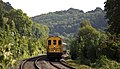
 Gloucester to Swindon Railway Line - geograph.org.uk - 898611.jpg 640 × 481 ; 213 kio
-
 Gloucester to Swindon Railway Line - geograph.org.uk - 898617.jpg 640 × 481 ; 228 kio
-
 Golden Valley at Brimscombe - geograph.org.uk - 3686491.jpg 1 600 × 915 ; 425 kio
-
 Golfers on Minchinhampton Common - geograph.org.uk - 2294281.jpg 1 500 × 1 000 ; 189 kio
-
-
 Grade II listed April Cottage, Minchinhampton - geograph.org.uk - 5002080.jpg 779 × 800 ; 170 kio
-
 Grade II listed former Ram Inn, Minchinhampton - geograph.org.uk - 5135402.jpg 800 × 649 ; 135 kio
-
 Grade II listed former Swan Inn, Minchinhampton - geograph.org.uk - 5002069.jpg 800 × 648 ; 118 kio
-

-

-
 Grade II listed Park Terrace Minchinhampton - geograph.org.uk - 5035289.jpg 800 × 724 ; 130 kio
-
 Grade II listed Priests House, Minchinhampton - geograph.org.uk - 5171229.jpg 800 × 692 ; 146 kio
-

-
 Gravestones in a Minchinhampton churchyard - geograph.org.uk - 5152535.jpg 800 × 787 ; 160 kio
_(2639605028)_(2).jpg)


_-_geograph.org.uk_-_4733370.jpg)


_listed_Greylands_in_Minchinhampton_-_geograph.org.uk_-_4988997.jpg)
