Category:Motukokako Island
Zur Navigation springen
Zur Suche springen
Insel in Neuseeland  | |||||
| Medium hochladen | |||||
| Ist ein(e) | |||||
|---|---|---|---|---|---|
| Benannt nach |
| ||||
| Ort | Far North District, Northland, Neuseeland | ||||
| Liegt am oder im Gewässer | |||||
| Breite |
| ||||
| Länge |
| ||||
| Einwohnerzahl |
| ||||
| Fläche |
| ||||
| Höhe über dem Meeresspiegel |
| ||||
 | |||||
Motukokako Island (Piercy Island) lies off Cape Brett, east of the Bay of Islands in New Zealand and is also known as "The Hole in the Rock".
Unterkategorien
Diese Kategorie enthält folgende Unterkategorie:
In Klammern die Anzahl der enthaltenen Kategorien (K), Seiten (S), Dateien (D)
H
Medien in der Kategorie „Motukokako Island“
Folgende 8 Dateien sind in dieser Kategorie, von 8 insgesamt.
-
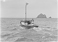
 "Seagull Auckland" boat near Motukokako Island (AM 87931-1).jpg 1.275 × 954; 681 KB
-
 "Seagull Auckland" boat near Motukokako Island (AM 87932-1).jpg 1.275 × 948; 695 KB
-
 .00 0665 Bay of Island (New Zealand) - Motukokako Island (Piercy Island).jpg 3.300 × 2.200; 8,19 MB
-
 Bledisloe Rosemary Cape Brett 1934 (AM 82376-1).jpg 1.275 × 923; 564 KB
-
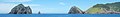 Cape Brett banner Motukokako Island (Piercy Island) off Cape Brett.jpg 4.860 × 694; 937 KB
-
 Motukokako Island (Piercy Island) off Cape Brett.jpg 4.860 × 2.880; 3,93 MB
-
 Piercy Island Alma G (AM 82375-1).jpg 1.275 × 915; 562 KB
-
 View of boat in the sea (AM 76100-1).jpg 1.275 × 945; 669 KB
.jpg)
.jpg)
_-_Motukokako_Island_(Piercy_Island).jpg)
.jpg)
_off_Cape_Brett.jpg)
.jpg)
.jpg)
_off_Cape_Brett.jpg)