Category:Mount Scott (Klamath County, Oregon)
Zur Navigation springen
Zur Suche springen
Berg in der Kaskadenkette .png) | |||||
| Medium hochladen | |||||
| Ist ein(e) | |||||
|---|---|---|---|---|---|
| Material | |||||
| Ort | Klamath County, Oregon | ||||
| Gebirgszug |
| ||||
| Schartenhöhe |
| ||||
| Climbing route | |||||
| Höhe über dem Meeresspiegel |
| ||||
 | |||||
Unterkategorien
Es werden 2 von insgesamt 2 Unterkategorien in dieser Kategorie angezeigt:
In Klammern die Anzahl der enthaltenen Kategorien (K), Seiten (S), Dateien (D)
C
- Crater Lake from Mount Scott (3 D)
M
- Mount Scott Trail (1 D)
Medien in der Kategorie „Mount Scott (Klamath County, Oregon)“
Folgende 28 Dateien sind in dieser Kategorie, von 28 insgesamt.
-
-
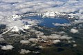
 Aerial Crater Lake (cropped).jpg 2.400 × 1.600; 1,98 MB
-
 Aerial Crater Lake.jpg 3.072 × 2.304; 4,57 MB
-
 Crater Lake 2 (cropped).jpg 2.175 × 1.450; 1,19 MB
-
 Crater Lake 2.jpg 2.560 × 1.920; 472 KB
-
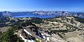
 Crater Lake from Mount Scott in 2011 (1).JPG 4.752 × 3.168; 6,13 MB
-
 Crater Lake from Mount Scott in 2011 (2) (cropped).jpg 4.272 × 2.136; 4,1 MB
-
 Crater Lake from Mount Scott in 2011 (2).JPG 4.752 × 3.168; 5,47 MB
-
 Crater Lake from Mount Scott in 2011 (3).JPG 4.752 × 3.168; 5,54 MB
-
 Crater Lake from Mount Scott in 2011 (4).JPG 4.752 × 3.168; 4,81 MB
-
 Crater Lake in Oregon in 2011 (2).JPG 4.752 × 3.168; 5,68 MB
-
 Crater Lake in Oregon in 2011 (8).JPG 4.752 × 3.168; 5,04 MB
-
 Crater Lake Mt Scott and The Phantom Ship From Garfield Peak.jpg 1.512 × 2.048; 2,39 MB
-
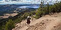 Crater Lake Mt Scott Trail 5.jpg 5.472 × 2.736; 12,01 MB
-
 Crater Lake National Park 2011.jpg 2.816 × 2.112; 1,16 MB
-
 Craterlake-panorama.jpg 7.112 × 1.414; 11,37 MB
-
 Fire tower on the top of Mount Scott in Oregon 2011.JPG 4.752 × 3.168; 6,09 MB
-

-
 Mazama general geologic map.gif 744 × 623; 45 KB
-
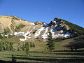
 Mount Scott (Oregon).png 400 × 291; 173 KB
-
 Mount Scott, Oregon 1.JPG 2.048 × 1.536; 1,65 MB
-
 Mount Scott, Oregon, USA - the top and a fire tower.jpg 2.592 × 3.872; 4,21 MB
-
 Mt scott crater lake.jpg 1.024 × 768; 213 KB
-
 NPS crater-lake-geologic-map.jpg 3.352 × 4.820; 4,13 MB
-
 NPS crater-lake-map.jpg 2.467 × 2.873; 1,74 MB
-
 Relief map of Crater Lake area.jpg 600 × 640; 62 KB
-

-
 View of Mt. Scott, Kim Wyttenberg (6501975363).jpg 3.872 × 2.592; 4,68 MB

.jpg)

.jpg)

.JPG)
_(cropped).jpg)
.JPG)
.JPG)
.JPG)
.JPG)
.JPG)


.jpg)
Kategorien:
- Mountains of Crater Lake National Park
- Subduction volcanoes in Oregon
- Stratovolcanoes in Oregon
- Mountains of Oregon
- Volcanoes in Oregon by name
- High Cascades
- Klamath County, Oregon
- 2720s mountains of the United States
- Crater Lake
- Highest points of national parks of the United States
- Volcanism of Crater Lake National Park
- Andesite and dacite of Mount Mazama
- Pre-Mazama rhyodacite and dacite
- Mount Mazama climactic eruption - Plinian and other Holocene pumice-fall deposits
- Mount Mazama climactic eruption - ignimbrite (fine grained, crystal rich)
- Quaternary slope movements in Oregon