Category:Nadelhorn
Vai alla navigazione
Vai alla ricerca
Deutsch: Nadelhorn
English: Nadelhorn
Italiano: Nadelhorn
montagna delle Alpi Pennine   | |||||
| Carica un file multimediale | |||||
| Istanza di | |||||
|---|---|---|---|---|---|
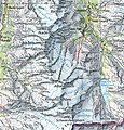
| Luogo | Vallese, Svizzera | ||||
| Catena montuosa | |||||
| Prominenza topografica |
| ||||
| Isolamento topografico |
| ||||
| Altezza sul mare |
| ||||
| Montagna principale | |||||
 | |||||
File nella categoria "Nadelhorn"
Questa categoria contiene 47 file, indicati di seguito, su un totale di 47.
-
 Allalinhorn Swisstopo.jpg 1 035 × 1 080; 1,08 MB
-
 Almageller Tal links oben, Furggstalden Mitte, Plattjen und Mittagshorn rechts.jpg 4 608 × 2 592; 2,63 MB
-
 Bruch im Hohbalmgletscher, staut sich an Punkt 3497 m.jpg 4 608 × 2 592; 2,15 MB
-
 Dom of Mischabel.jpg 3 527 × 2 352; 4,75 MB
-
 Dom von Westen morgens.jpg 866 × 850; 101 KB
-
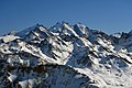
 Dom, Nadelhorn, Hohberghorn and Dürrenhorn (15214340430).jpg 5 184 × 3 456; 5,71 MB
-
 Dom, Nadelhorn, Hohberghorn and Dürrenhorn (15222159660).jpg 5 184 × 3 456; 4,93 MB
-
-
 ETH-BIB-Nadelhorn, Dom, Täschhorn, Alphubel v. N. aus 4800 m-Inlandflüge-LBS MH01-001038.tif 6 127 × 4 443; 78,06 MB
-
 ETH-BIB-Nadelhorn, Dom, Täschhorn, Matterhorn-Inlandflüge-LBS MH05-54-34.tif 3 508 × 2 334; 23,47 MB
-
 ETH-BIB-Nadelhorn, Dom, Täschhorn, Matterhorn-Inlandflüge-LBS MH05-54-35.tif 3 508 × 2 339; 23,53 MB
-
 ETH-BIB-Nadelhorn, Dom, Täschhorn, Matterhorn-Inlandflüge-LBS MH05-54-36.tif 3 508 × 2 340; 23,54 MB
-
 ETH-BIB-Nadelhorn, Stecknadelhorn, Dom, Monte Rosa-Inlandflüge-LBS MH05-54-37.tif 3 508 × 2 347; 23,61 MB
-
 Hohberghorn, Stecknadelhorn, Nadelhorn, Dom and Täschhorn (22824408215).jpg 5 184 × 3 456; 5,85 MB
-
 Lenzspitze and Nadelhorn with Dom to the left.jpg 5 760 × 3 840; 7,06 MB
-
 Lenzspitze, Nadelhorn, Hohberghorn and Dürrenhorn (15366661916).jpg 5 184 × 3 456; 5,57 MB
-
 Lenzspitze, Nadelhorn, Windjoch, Ulrichshorn von Saas Grund.jpg 4 608 × 2 592; 2,06 MB
-
 LenzspitzeNadelhorn.jpg 1 024 × 768; 229 KB
-
 Leone vom Nadelhorn-Normalweg.jpg 2 316 × 1 425; 703 KB
-
 Loch im Nadelhorn.jpg 4 608 × 2 592; 2,95 MB
-
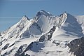
 LtoR Nadelhorn 4327m Dom 4545m Täschhorn 4491m Breithorn 4164m.jpg 4 896 × 3 672; 6,5 MB
-
 LtoR Nadelhorn 4327m Dom 4545m Täschhorn 4491m.jpg 4 896 × 3 672; 6,59 MB
-
 Mischabelgruppe im Herbst.jpg 6 000 × 4 000; 6,72 MB
-
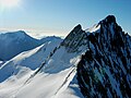
 Nadelgrat Nadelhorn.jpg 3 936 × 2 876; 3,58 MB
-
 Nadelgrat.jpg 3 410 × 2 299; 376 KB
-
 NadelgratFromDom.JPG 4 320 × 3 240; 5,44 MB
-
 Nadelhorn e Lenzspitze.JPG 4 000 × 3 000; 4,26 MB
-
 Nadelhorn Gipfel2001.jpg 956 × 616; 124 KB
-
 Nadelhorn shadows.jpg 1 536 × 1 047; 247 KB
-
 Nadelhorn Spherical Panorama.jpg 20 992 × 10 496; 24,24 MB
-
 Nadelhorn, Dom & Täschhorn.jpg 5 568 × 3 712; 12,09 MB
-
 Nadelhorn, Dom and Täschhorn.jpg 5 568 × 3 712; 14,55 MB
-
 Nadelhorn, Dom, Täschhorn, Bishorn & Weisshorn.jpg 5 568 × 3 584; 11,13 MB
-
 Nadelhorn, Stecknadelhorn, Dirruhorn, Riedgletscher.jpg 5 760 × 3 840; 2,21 MB
-
 Nadelhorn.jpg 640 × 480; 129 KB
-
 Nadelhorn01.jpg 695 × 521; 134 KB
-
 Nadelhorn2.jpg 1 024 × 768; 317 KB
-
 NadelhornFromNE.JPG 2 136 × 2 848; 1,59 MB
-
 Riedgletscher, Dirrhhorn, Gugla, Stecknadelhorn, Nadelhorn und Hohberghorn.jpg 5 760 × 3 840; 5,94 MB
-
 Riedgletscher.jpg 1 024 × 768; 109 KB
-
 Rimpfischhorn - Nadelhorn mountain range from Hohsaas.jpg 5 760 × 3 840; 6,27 MB
-
 Täschhorn, Dom and Nadelhorn (15233632558).jpg 5 184 × 3 456; 6,12 MB
-
 Täschhorn, Dom, and Nadelhorn (15232156980).jpg 5 184 × 3 456; 6,92 MB
-
 Täschhorn, Dom, Nadelhorn and Balfrin (15420220785).jpg 5 184 × 3 456; 6,97 MB
-
 Ulrichshorn.jpg 4 608 × 2 592; 2,52 MB
-
 Weismies, was ist hinter Morteratsch.jpg 4 608 × 2 592; 2,68 MB
-
 Weisshorn Dom und Rimpfischhorn von Cry d'Er.jpg 5 760 × 3 840; 4,32 MB


.jpg)
.jpg)
.jpg)

.jpg)


.jpg)
.jpg)
.jpg)


