Category:Neuhemsbach
Vai alla navigazione
Vai alla ricerca
municipality of Germany    | |||||
| Carica un file multimediale | |||||
| Istanza di |
| ||||
|---|---|---|---|---|---|
| Luogo | circondario di Kaiserslautern, Renania-Palatinato, Germania | ||||
| Popolazione |
| ||||
| Superficie |
| ||||
| Altezza sul mare |
| ||||
| sito web ufficiale | |||||
 | |||||
Sottocategorie
Questa categoria contiene le 3 sottocategorie indicate di seguito, su un totale di 3.
File nella categoria "Neuhemsbach"
Questa categoria contiene 18 file, indicati di seguito, su un totale di 18.
-
 2007 09 23 Neuhemsbacher Kerwe mit Kerweredner.jpg 2 359 × 1 529; 745 KB
-
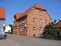
 Bauernhof (ehem.), Hauptstraße 50.jpg 2 592 × 1 944; 1,22 MB
-
 Bürgerhaus.JPG 2 592 × 1 944; 1,6 MB
-
 Dorfgemeinschaftshaus.JPG 2 592 × 1 944; 1,29 MB
-
 Garten mit Gartenlaube in der Ortsmitte.jpg 2 592 × 1 944; 2,49 MB
-
 Gartenlaube in der Ortsmitte.JPG 2 592 × 1 944; 2,14 MB
-
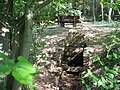 Hemsbachquelle.JPG 2 592 × 1 944; 1,95 MB
-
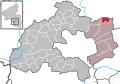 Neuhemsbach in KL.svg 296 × 205; 205 KB
-
 Neuhemsbach mit Billesweiher.jpg 2 592 × 1 944; 1,77 MB
-
 Neuhemsbach, Südansicht.JPG 2 592 × 1 944; 1,32 MB
-
 Rosskastanienbaum Neuhemsbach, Ortsmitte.jpg 1 612 × 1 988; 739 KB
-
 Schloßberg-Brunnen mit Wohnhaus.jpg 2 592 × 1 944; 1,72 MB
-
 Spitzhuebel tower.jpg 761 × 1 219; 515 KB
-
 Wohnhaus 02 Neuhemsbach.jpg 3 024 × 4 032; 3,27 MB
-
 Wohnhaus, Alsenborner Straße 19.jpg 1 944 × 2 592; 1,22 MB
-
 Wohnhaus, Hauptstraße 54.jpg 2 592 × 1 944; 1,26 MB
-
 Wohnhaus, Ortsmitte.JPG 2 592 × 1 944; 1,51 MB
-
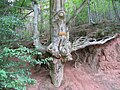 Wurzelbuche im Heinzental.jpg 2 592 × 1 944; 2,09 MB

,_Hauptstra%C3%9Fe_50.jpg)


