Category:North Cheriton
Aller à la navigation
Aller à la recherche
English: North Cheriton is a small village and civil parish in South Somerset with a population of 254. It is located on the A357 south-west of Wincanton.
localité britannique du comté anglais de Somerset  | |||||
| Téléverser des médias | |||||
| Nature de l’élément | |||||
|---|---|---|---|---|---|
| Lieu | South Somerset, Somerset, Angleterre du Sud-Ouest, Angleterre | ||||
 | |||||
Sous-catégories
Cette catégorie comprend 2 sous-catégories, dont les 2 ci-dessous.
N
- North Cheriton War Memorial (1 F)
Média dans la catégorie « North Cheriton »
Cette catégorie comprend 25 fichiers, dont les 25 ci-dessous.
-
 B3145 approaching Clare Farm - geograph.org.uk - 4045266.jpg 640 × 411 ; 65 kio
-
 Beech tree at entrance to North Cheriton manor - geograph.org.uk - 1099390.jpg 480 × 640 ; 116 kio
-
 Bend approaching North Cheriton Cemetery - geograph.org.uk - 4045141.jpg 640 × 389 ; 50 kio
-
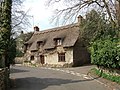 Cottage at North Cheriton - geograph.org.uk - 398380.jpg 640 × 480 ; 152 kio
-
 Fives Wall - geograph.org.uk - 4248930.jpg 640 × 480 ; 70 kio
-
 Fives Wall - geograph.org.uk - 4248938.jpg 640 × 480 ; 85 kio
-
 Footpath to Lattiford and Wincanton - geograph.org.uk - 520704.jpg 480 × 640 ; 113 kio
-
 Grove Lane junction with A357 - geograph.org.uk - 3417998.jpg 640 × 345 ; 63 kio
-
 Lane near North Cheriton - geograph.org.uk - 5407322.jpg 640 × 427 ; 97 kio
-
 North Cheriton Chapel - geograph.org.uk - 6202093.jpg 6 570 × 4 379 ; 7,56 Mio
-
 North Cheriton Chapel - geograph.org.uk - 6202096.jpg 6 680 × 4 453 ; 7,54 Mio
-
 North Cheriton Manor - geograph.org.uk - 398392.jpg 640 × 480 ; 132 kio
-
 North Cheriton, Elm Cottage sign, Hardings Lane - geograph.org.uk - 6202108.jpg 5 861 × 3 907 ; 6,52 Mio
-
 North Cheriton, Elm Cottage, Hardings Lane - geograph.org.uk - 6202103.jpg 5 937 × 3 958 ; 7,12 Mio
-

-
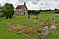
 North Cheriton, St John the Baptist - geograph.org.uk - 6365908.jpg 3 456 × 4 608 ; 5,09 Mio
-
 North Chriton chapel.jpg 640 × 480 ; 145 kio
-
 Old Direction Sign - Signpost by the A357, North Cheriton - geograph.org.uk - 6049084.jpg 1 619 × 1 278 ; 488 kio
-
 Old Direction Sign - Signpost by the A357, North Cheriton parish - geograph.org.uk - 6050108.jpg 1 573 × 1 138 ; 387 kio
-
 Quiet Lane in North Cheriton - geograph.org.uk - 398382.jpg 640 × 480 ; 180 kio
-
 Bow Brook - geograph.org.uk - 520701.jpg 480 × 640 ; 136 kio
-

-
 Grove Lane - geograph.org.uk - 520716.jpg 640 × 480 ; 97 kio
-
 Quarry Plantation - geograph.org.uk - 560847.jpg 640 × 425 ; 73 kio
-
 Walled Garden In Field Near Maperton - geograph.org.uk - 306420.jpg 640 × 480 ; 76 kio


