Category:Ouachita River
Vai alla navigazione
Vai alla ricerca
river in the south-central United States   | |||||
| Carica un file multimediale | |||||
| Istanza di | |||||
|---|---|---|---|---|---|
| Luogo | |||||
| Lunghezza |
| ||||
| Foce |
| ||||
| Bacino di drenaggio |
| ||||
| Affluente |
| ||||
 | |||||
Sottocategorie
Questa categoria contiene le 4 sottocategorie indicate di seguito, su un totale di 4.
File nella categoria "Ouachita River"
Questa categoria contiene 29 file, indicati di seguito, su un totale di 29.
-
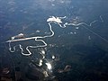
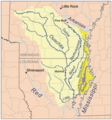
 Ouachita watershed.png 288 × 336; 80 KB
-
 1796 blackriverOuachita.jpg 3 120 × 4 160; 2,22 MB
-
 AR Ouachita National Forest.jpg 1 280 × 848; 301 KB
-
 Calion, AR (4705082093).jpg 1 600 × 1 200; 159 KB
-
 Ouachita River basin - main report (IA CAT80742999).pdf 1 172 × 1 608, 160 pagine; 9,99 MB
-
 Columbia Lock & Dam in the morning fog.jpg 5 190 × 2 521; 15,76 MB
-
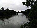
 Columbia on the Ouachita, LA, IMG 2705.JPG 4 320 × 3 240; 2,68 MB
-
 Floating camp on the Ouachita River.jpg 1 024 × 683; 1,15 MB
-
 Fort Miro or Post of Ouachita on the Ouachita River.jpg 2 967 × 3 955; 1,14 MB
-

-

-
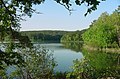
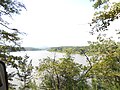
 Lake Ouachita north of Mount Ida, Arkansas.jpg 4 032 × 3 024; 2,09 MB
-
 Map of Ouachita River in Louisiana.jpg 2 727 × 3 636; 1,27 MB
-
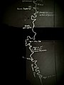
 Map of the Ouachita River and its fords - NARA - 109182798 (page 2).jpg 11 141 × 7 264; 6,44 MB
-
 Map of the Parish of Catahoula, Louisiana LOC 2012592312.jpg 3 099 × 3 394; 1,35 MB
-

-
 Ouachita River at Arkadelphia, AR.jpg 3 648 × 2 736; 3,59 MB
-
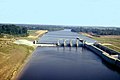
 Ouachita River Lock and Dam No. 8.jpg 5 726 × 4 542; 2,33 MB
-
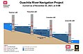 Ouachita River Navigation Project.jpg 2 550 × 1 650; 406 KB
-
 Ouachita River Navigation Project.png 2 550 × 1 650; 172 KB
-
 Ouachita River, Arkansas.jpg 2 560 × 1 920; 559 KB
-
 Stephens Park, Garland County, AR.jpg 5 248 × 2 952; 8,03 MB
-
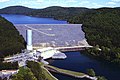 USACE Blakely Mountain Dam.jpg 1 500 × 1 001; 547 KB
-
 USACE Columbia Lock Ouachita River.jpg 1 500 × 1 001; 319 KB
-
 USACE Felsenthal Lock and Dam.jpg 1 500 × 1 199; 558 KB
-
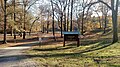
 Womble Trail.JPG 4 608 × 3 456; 6,57 MB
-
 Boeufrivermap.png 465 × 500; 223 KB
-
 Littlemorivermap.png 465 × 500; 217 KB
-
 Tensasrivermap.png 465 × 500; 221 KB


.jpg)


_(14773546951).jpg)
._Traduit_de_l%27allemand,_avec_l%27autorisation_de_l%27auteur_et_annot%C3%A9e_sous_la_direction_de_Emm._de_Margerie._Avec_une_pr%C3%A9f._par_Marcel_Bertrand_(1897)_(14591489198).jpg)


.jpg)


