Category:Over Kellet
Vai alla navigazione
Vai alla ricerca
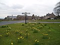
English: Over Kellet is a village and civil parish near Carnforth in the English county of Lancashire. The parish, which is in the City of Lancaster, includes the village of Capernwray, at its northern end, and has a population of 778. The Lancaster Canal passes through the parish. (→Over Kellet)
Nederlands: Over Kellet is een plaats en civil parish in het bestuurlijke gebied Lancaster, in het Engelse graafschap Lancashire met 778 inwoners. (→Over Kellet)
Polski: Over Kellet – wieś w Anglii, w hrabstwie Lancashire, w dystrykcie Lancaster. Leży 81 km na północny zachód od miasta Manchester i 340 km na północny zachód od Londynu. W 2001 miejscowość liczyła 778 mieszkańców. (→Over Kellet)
village in the United Kingdom  | |||||
| Carica un file multimediale | |||||
| Istanza di | |||||
|---|---|---|---|---|---|
| Luogo | City of Lancaster, Lancashire, Nord Ovest dell'Inghilterra, Inghilterra | ||||
| Considerato essere uguale a | Over Kellet (pagina Wikimedia duplicata, parrocchia civile dell'Inghilterra) | ||||
 | |||||
Sottocategorie
Questa categoria contiene le 3 sottocategorie indicate di seguito, su un totale di 3.
A
- A601(M) motorway (5 F)
C
- Capernwray Viaduct (8 F)
File nella categoria "Over Kellet"
Questa categoria contiene 200 file, indicati di seguito, su un totale di 284.
(pagina precedente) (pagina successiva)-

-
 18th Century house, Over Kellet - geograph.org.uk - 2261102.jpg 640 × 480; 81 KB
-
 A bend in Kellet Lane - geograph.org.uk - 4690846.jpg 640 × 480; 48 KB
-
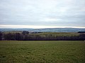
 A prospect over the Keer Valley - geograph.org.uk - 4652670.jpg 800 × 600; 132 KB
-
 A reservoir - geograph.org.uk - 4651025.jpg 640 × 480; 84 KB
-
 A sheep in trouble by the Keer - geograph.org.uk - 3532231.jpg 480 × 640; 91 KB
-
 Another blot on the landscape - geograph.org.uk - 4651017.jpg 800 × 600; 162 KB
-

-

-
 Approaching junction 35 on the M6, northbound - geograph.org.uk - 2712827.jpg 3 081 × 2 307; 722 KB
-

-
 B6254 bridge, M6 - geograph.org.uk - 2637146.jpg 640 × 379; 29 KB
-
 B6254 east of Over Kellet - geograph.org.uk - 2898287.jpg 640 × 480; 111 KB
-
 B6254 in Over Kellet village - geograph.org.uk - 6152489.jpg 1 024 × 767; 93 KB
-
 B6254 Kellet Road looking west - geograph.org.uk - 6152490.jpg 1 024 × 768; 85 KB
-
 B6254 near Broad Moss Wood - geograph.org.uk - 6143485.jpg 1 024 × 769; 95 KB
-
 B6254 near Broad Moss Wood - geograph.org.uk - 6152484.jpg 1 024 × 768; 101 KB
-
 B6254 near Red Well Inn - geograph.org.uk - 6143484.jpg 1 024 × 769; 178 KB
-
 B6254 nearing Over Kellet - geograph.org.uk - 6152486.jpg 1 024 × 767; 169 KB
-
 B6254 towards Arkholme - geograph.org.uk - 5923296.jpg 640 × 480; 113 KB
-
 B6257 overbridge, M6 - geograph.org.uk - 3231984.jpg 640 × 430; 43 KB
-
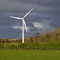
 Back Lane Quarry wind turbine - geograph.org.uk - 3497407.jpg 640 × 475; 136 KB
-
 Back Lane Quarry wind turbine - geograph.org.uk - 4936676.jpg 640 × 640; 165 KB
-
 Bench and cottages, Over Kellet - geograph.org.uk - 4655002.jpg 800 × 600; 169 KB
-

-
 Bench mark, Old Hall, Over Kellet - geograph.org.uk - 2261828.jpg 640 × 480; 136 KB
-

-
 Birkland Barrow - geograph.org.uk - 1772709.jpg 640 × 480; 190 KB
-
 Bowman Stout Wood, Over Kellet - geograph.org.uk - 30391.jpg 640 × 480; 59 KB
-
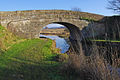
 Bridge 130, Lancaster Canal - geograph.org.uk - 2443020.jpg 640 × 425; 322 KB
-
 Bridge 133, Lancaster Canal - geograph.org.uk - 2245984.jpg 640 × 418; 182 KB
-
 Bridge over the M6 - geograph.org.uk - 3101787.jpg 4 120 × 2 625; 5,13 MB
-
 Canal boat by Kellet Lane Bridge - geograph.org.uk - 1595861.jpg 640 × 480; 116 KB
-
 Canalside road at Capernwray - geograph.org.uk - 3753828.jpg 4 320 × 3 240; 5,58 MB
-
 Capernwray Diving Centre (geograph 1843558).jpg 640 × 480; 75 KB
-
 Capernwray Diving Centre (geograph 1843566).jpg 640 × 480; 91 KB
-
 Capernwray Evangelical Church - geograph.org.uk - 1508402.jpg 640 × 480; 237 KB
-
 Capernwray Evangelical Church - geograph.org.uk - 2691086.jpg 640 × 480; 106 KB
-
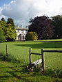
 Capernwray Hall - geograph.org.uk - 1849085.jpg 640 × 480; 82 KB
-
 Capernwray Hall - geograph.org.uk - 2751573.jpg 640 × 425; 342 KB
-
 Capernwray Hall - geograph.org.uk - 4665831.jpg 5 097 × 3 398; 1,95 MB
-
 Capernwray Hall from Borwick railway bridge - geograph.org.uk - 5486997.jpg 4 545 × 2 795; 1,02 MB
-
 Capernwray Hall from Dalton Park Wood - geograph.org.uk - 5487843.jpg 3 360 × 5 040; 1,55 MB
-
 Capernwray Hall swimming pool, January 1976 - geograph.org.uk - 5486663.jpg 5 040 × 3 360; 1,33 MB
-
 Capernwray Hall, 1981 - geograph.org.uk - 5486644.jpg 5 040 × 3 360; 1,63 MB
-
 Capernwray Park - geograph.org.uk - 1849066.jpg 640 × 480; 85 KB
-

-
 Carnforth Business Park - geograph.org.uk - 3497421.jpg 640 × 425; 120 KB
-
 Carnforth Business Park - geograph.org.uk - 3497439.jpg 640 × 425; 145 KB
-
 Cattle grazing east of Over Kellet - geograph.org.uk - 5923268.jpg 640 × 480; 66 KB
-
 Conference hall seen from main tower, Capernwray Hall - geograph.org.uk - 5486635.jpg 5 040 × 3 360; 1,94 MB
-
 Construction of Carnforth Business Park - geograph.org.uk - 2890564.jpg 640 × 425; 132 KB
-
 Construction of Carnforth Business Park - geograph.org.uk - 2890568.jpg 640 × 425; 160 KB
-
 Construction of Carnforth Business Park - geograph.org.uk - 2890574.jpg 640 × 425; 124 KB
-
 Construction of Carnforth Business Park - geograph.org.uk - 2890583.jpg 640 × 425; 189 KB
-
 Construction of Carnforth Business Park - geograph.org.uk - 2890617.jpg 640 × 425; 137 KB
-
 Construction of Carnforth Business Park - geograph.org.uk - 2890624.jpg 640 × 425; 115 KB
-

-
 Courtyard seen from main tower, Capernwray Hall - geograph.org.uk - 5485269.jpg 3 360 × 5 040; 1,44 MB
-
 Craggs, Over Kellet - geograph.org.uk - 1847110.jpg 640 × 480; 68 KB
-
 Crossroads, Over Kellet - geograph.org.uk - 4546952.jpg 1 024 × 913; 793 KB
-

-
 Date stone, Capernwray Church - geograph.org.uk - 1850984.jpg 480 × 640; 106 KB
-
 Derelict Barn - geograph.org.uk - 891667.jpg 640 × 480; 83 KB
-
 Derelict barn near Over Kellet - geograph.org.uk - 1508391.jpg 640 × 480; 126 KB
-
 Descending towards Kellet Park Wood - geograph.org.uk - 1847028.jpg 640 × 480; 53 KB
-

-

-

-
 Entering Over Kellet - geograph.org.uk - 4690821.jpg 640 × 480; 62 KB
-
 Entrance road for Leapers Wood Quarry - geograph.org.uk - 2261830.jpg 640 × 480; 130 KB
-
 Entrance to Leapers Wood Quarry - geograph.org.uk - 3909907.jpg 3 872 × 2 592; 4,17 MB
-
 Farmland near Birkland Barrow - geograph.org.uk - 4678386.jpg 640 × 480; 58 KB
-
 Farmland near Swarthdale - geograph.org.uk - 1924025.jpg 800 × 531; 179 KB
-
 Field boundary near Carnforth - geograph.org.uk - 2262234.jpg 640 × 480; 115 KB
-

-

-
 Fields off Kirkby Lonsdale Road - geograph.org.uk - 5923283.jpg 640 × 480; 45 KB
-
 Fire in the sky above Over Kellet - geograph.org.uk - 3187227.jpg 600 × 800; 89 KB
-

-
 Flooded field near Over Kellet - geograph.org.uk - 6290077.jpg 1 280 × 720; 328 KB
-
 Fringe of trees near Gamekeeper's Tower - geograph.org.uk - 1847058.jpg 640 × 480; 107 KB
-
 From tarmac to grass - geograph.org.uk - 846190.jpg 640 × 480; 198 KB
-
 From the Towpath - geograph.org.uk - 1659746.jpg 640 × 480; 99 KB
-
 Gamekeeper's Tower - geograph.org.uk - 1847050.jpg 640 × 480; 90 KB
-
 Gamekeeper's Tower - geograph.org.uk - 211124.jpg 640 × 488; 121 KB
-
 Gated private track off Kellet Lane - geograph.org.uk - 4678436.jpg 640 × 480; 101 KB
-
 Grazing and hedgerow - geograph.org.uk - 4690818.jpg 640 × 480; 62 KB
-
 Grazing and hedgerow - geograph.org.uk - 4690836.jpg 640 × 480; 62 KB
-
 Grazing land - geograph.org.uk - 6046780.jpg 1 280 × 720; 408 KB
-
 Grazing land near Over Kellet - geograph.org.uk - 1866678.jpg 640 × 346; 208 KB
-
 Grazing land, Carnforth - geograph.org.uk - 2416935.jpg 640 × 425; 216 KB
-
 Grazing land, Carnforth - geograph.org.uk - 2416943.jpg 640 × 425; 272 KB
-
 Grazing near Birkland Barrow - geograph.org.uk - 4678389.jpg 640 × 480; 70 KB
-
 Grazing off Kellet Lane - geograph.org.uk - 4678398.jpg 640 × 480; 57 KB
-
 Grazing off Kellet Lane - geograph.org.uk - 4690845.jpg 640 × 480; 44 KB
-
 Groundwork for Carnforth Business Park - geograph.org.uk - 2625630.jpg 640 × 425; 210 KB
-
 Half a mile south of junction 35 - geograph.org.uk - 1867503.jpg 1 956 × 1 354; 411 KB
-
 Hall Garth, Over Kellet.jpg 480 × 640; 142 KB
-
 Havelock Hill - geograph.org.uk - 4129896.jpg 2 560 × 1 920; 3,43 MB
-
 High Snab Farm - geograph.org.uk - 5417327.jpg 5 000 × 3 086; 1,89 MB
-
 Hogarth House, Over Kellet - geograph.org.uk - 4654993.jpg 800 × 600; 154 KB
-
 House in Over Kellet - geograph.org.uk - 4690826.jpg 640 × 480; 52 KB
-
 Houses - geograph.org.uk - 891640.jpg 640 × 480; 84 KB
-
 Houses - geograph.org.uk - 891644.jpg 640 × 480; 92 KB
-
 In Lord's Lot Wood - geograph.org.uk - 2100029.jpg 1 920 × 2 560; 1,71 MB
-
 In Lord's Lot Wood - geograph.org.uk - 2100030.jpg 1 920 × 2 560; 1,69 MB
-

-
 Jackdaw Quarry, Capernwray - geograph.org.uk - 2057747.jpg 640 × 480; 107 KB
-
 Jackdaw Quarry, Capernwray - geograph.org.uk - 2057748.jpg 640 × 480; 156 KB
-

-
 Junction 35 on the M6 - geograph.org.uk - 1867513.jpg 2 323 × 1 727; 598 KB
-
 Junction 35 on the M6 - geograph.org.uk - 1867563.jpg 1 466 × 1 029; 301 KB
-
 Junction 35 on the M6, northbound - geograph.org.uk - 2712917.jpg 2 669 × 1 997; 673 KB
-
 Junction 35 turnoff M6 north - geograph.org.uk - 2945923.jpg 640 × 435; 58 KB
-
 Junction 35, M6 - geograph.org.uk - 2637147.jpg 640 × 430; 27 KB
-

-
 Junction on Kellet Road for the M6 - geograph.org.uk - 2057749.jpg 640 × 480; 103 KB
-
 Keer Aqueduct, Lancaster Canal - geograph.org.uk - 4901520.jpg 425 × 640; 180 KB
-

-
 Kellet Hill - geograph.org.uk - 3774986.jpg 2 560 × 1 920; 2,55 MB
-
 Kellet Lane - geograph.org.uk - 3120882.jpg 3 636 × 3 456; 2,66 MB
-
 Kellet Lane - geograph.org.uk - 4690834.jpg 640 × 480; 56 KB
-
 Kellet Lane - geograph.org.uk - 4690837.jpg 640 × 480; 53 KB
-
 Kellet Lane - geograph.org.uk - 4690839.jpg 640 × 480; 82 KB
-
 Kellet Lane - geograph.org.uk - 4690842.jpg 640 × 480; 96 KB
-
 Kellet Lane - geograph.org.uk - 4690843.jpg 640 × 480; 59 KB
-
 Kellet Lane Bridge - geograph.org.uk - 5186454.jpg 640 × 480; 104 KB
-
 Kellet Lane Bridge No 130 - geograph.org.uk - 6104920.jpg 800 × 528; 125 KB
-
 Kellet Lane Bridge, Lancaster Canal - geograph.org.uk - 3438709.jpg 2 048 × 1 536; 581 KB
-
 Kellet Lane Bridge.jpg 640 × 425; 372 KB
-
 Kellet Road (B6254) - geograph.org.uk - 5923264.jpg 640 × 480; 54 KB
-
 Kellet Road, Over Kellet - geograph.org.uk - 4690828.jpg 640 × 480; 65 KB
-
 Kirk House Farm - geograph.org.uk - 5698913.jpg 1 280 × 720; 486 KB
-
 Kirkby Lonsdale Road (B6254) - geograph.org.uk - 5923272.jpg 640 × 480; 71 KB
-
 Kirkby Lonsdale Road - geograph.org.uk - 5923285.jpg 640 × 480; 61 KB
-
 Kit Bill Wood - geograph.org.uk - 1879910.jpg 640 × 425; 476 KB
-
 Lancaster Canal - geograph.org.uk - 1659748.jpg 640 × 480; 89 KB
-
 Lancaster Canal - geograph.org.uk - 1659751.jpg 640 × 480; 72 KB
-
 Lancaster Canal - geograph.org.uk - 1659752.jpg 640 × 480; 113 KB
-
 Lancaster Canal - geograph.org.uk - 2123231.jpg 2 560 × 1 920; 1,03 MB
-
 Lancaster Canal - geograph.org.uk - 2123235.jpg 2 560 × 1 920; 1,86 MB
-
 Lancaster Canal - geograph.org.uk - 2169985.jpg 640 × 425; 336 KB
-
 Lancaster Canal - geograph.org.uk - 2169993.jpg 640 × 425; 384 KB
-
 Lancaster Canal - geograph.org.uk - 2751571.jpg 640 × 425; 409 KB
-
 Lancaster Canal - geograph.org.uk - 5186432.jpg 640 × 480; 54 KB
-
 Lancaster Canal from Kellet Lane Bridge - geograph.org.uk - 3120878.jpg 4 608 × 3 456; 3,35 MB
-
 Lancaster Canal, Capernwray - geograph.org.uk - 3334070.jpg 640 × 425; 166 KB
-
 Lancaster Canal, Capernwray - geograph.org.uk - 3334079.jpg 640 × 425; 201 KB
-
 Lane near Over Kellet - geograph.org.uk - 1847107.jpg 640 × 480; 83 KB
-
 Lane to Kirk House near Over Kellet - geograph.org.uk - 1924034.jpg 800 × 531; 228 KB
-
 Leaper's View and Church Bank - geograph.org.uk - 891654.jpg 640 × 480; 69 KB
-
 Leaper's Wood Quarry at Carnforth - geograph.org.uk - 3177140.jpg 3 264 × 2 448; 3,03 MB
-
 Lord's Lot Road - geograph.org.uk - 1540575.jpg 640 × 480; 249 KB
-
 Lord's Lot Road - geograph.org.uk - 1847066.jpg 640 × 480; 67 KB
-
 Lord's Lot Road - geograph.org.uk - 2220227.jpg 640 × 480; 114 KB
-
 Lune Valley drumlin country - geograph.org.uk - 2220193.jpg 640 × 480; 69 KB
-
 Lune Valley Smoke House and The Red Well - geograph.org.uk - 4546970.jpg 1 024 × 768; 678 KB
-
 M6 at Back Lane Quarry wind turbine - geograph.org.uk - 3894436.jpg 2 592 × 1 936; 1,63 MB
-
 M6 at junction 35 - geograph.org.uk - 3100837.jpg 4 240 × 2 398; 4,31 MB
-
 M6 Junction 35 - geograph.org.uk - 2475988.jpg 640 × 456; 54 KB
-
 M6 Junction 35 - geograph.org.uk - 2875503.jpg 640 × 397; 103 KB
-
 M6 Motorway - geograph.org.uk - 4878018.jpg 5 140 × 2 780; 1,98 MB
-
 M6 northbound, Carnforth - geograph.org.uk - 5923257.jpg 640 × 463; 53 KB
-
 M6 Over Kellett - geograph.org.uk - 2475976.jpg 640 × 480; 54 KB
-
 M6 Southbound, Bridge at Junction 35 - geograph.org.uk - 2683529.jpg 640 × 480; 163 KB
-
 M6, Junction 35 - geograph.org.uk - 3231976.jpg 640 × 408; 41 KB
-
 M6, Junction 35 overbridges - geograph.org.uk - 3231979.jpg 640 × 430; 44 KB
-
 M6, southbound - geograph.org.uk - 3231987.jpg 640 × 430; 40 KB
-
 Milestone, Lancaster Canal - geograph.org.uk - 1659754.jpg 640 × 480; 123 KB
-
 Minor road towards Capernwray - geograph.org.uk - 4690832.jpg 640 × 480; 91 KB
-
 Minor road towards Over Kellet - geograph.org.uk - 4690815.jpg 640 × 480; 61 KB
-
 Minor road towards Over Kellet - geograph.org.uk - 4690820.jpg 640 × 480; 71 KB
-
 Minor road towards Swarthdale - geograph.org.uk - 5923273.jpg 640 × 480; 81 KB
-
 Motorway and molehills - geograph.org.uk - 2262227.jpg 640 × 480; 96 KB
-
 Motorway bridge, Lancaster Canal - geograph.org.uk - 2443022.jpg 640 × 425; 261 KB
-
 Mud, glorious mud - geograph.org.uk - 2751570.jpg 640 × 425; 426 KB
-
 New conference hall, Capernwray Hall - geograph.org.uk - 5590732.jpg 2 592 × 1 944; 577 KB
-

-
 North from Lord's Lot Road - geograph.org.uk - 2220208.jpg 640 × 480; 83 KB
-

-

-
 Old ash tree - geograph.org.uk - 1879905.jpg 640 × 425; 435 KB
-
 Old Hall, Over Kellet - geograph.org.uk - 2261095.jpg 640 × 480; 87 KB
-
 Outlet from Pedder Potts Reservoir - geograph.org.uk - 6361536.jpg 1 280 × 850; 694 KB
-
 Over Kellet , M6 Motorway - geograph.org.uk - 6300560.jpg 6 000 × 4 000; 4,63 MB
-
 Over Kellet , M6 Motorway - geograph.org.uk - 6300563.jpg 6 000 × 4 000; 4,52 MB
-
 Over Kellet - geograph.org.uk - 1772720.jpg 640 × 425; 283 KB
-
 Over Kellet Pond - geograph.org.uk - 1508390.jpg 480 × 640; 268 KB
-
 Over Kellet Post Office and Store - geograph.org.uk - 891660.jpg 640 × 480; 66 KB
-

-
 Over Kellet village green - geograph.org.uk - 1807172.jpg 640 × 425; 153 KB
-
 Over Kellet Village Green - geograph.org.uk - 2057743.jpg 640 × 480; 125 KB
-
 Over Kellet village green - geograph.org.uk - 3262410.jpg 640 × 425; 138 KB
-
 Over Kellet village green - geograph.org.uk - 762410.jpg 640 × 480; 122 KB
-
 Over Kellet village green - geograph.org.uk - 772110.jpg 640 × 480; 67 KB
-

-
 Over Kellet village shop - geograph.org.uk - 762417.jpg 640 × 480; 116 KB
-
 Over Kellet, Lancashire, St Cuthbert - geograph.org.uk - 5910268.jpg 4 608 × 3 456; 4,05 MB
-
 Over Kellett , M6 Motorway - geograph.org.uk - 6359823.jpg 6 000 × 4 000; 5,48 MB


.jpg)
.jpg)


_-_geograph.org.uk_-_5923271.jpg)


_-_geograph.org.uk_-_5923264.jpg)


_-_geograph.org.uk_-_5923272.jpg)


_-_geograph.org.uk_-_3944253.jpg)


