Category:Parowan, Utah
Vai alla navigazione
Vai alla ricerca
comune statunitense dello Utah   | |||||
| Carica un file multimediale | |||||
| Istanza di | |||||
|---|---|---|---|---|---|
| Luogo | contea di Iron, Utah, Stati Uniti d'America | ||||
| Capo del governo |
| ||||
| Data di fondazione o creazione |
| ||||
| Popolazione |
| ||||
| Superficie |
| ||||
| Altezza sul mare |
| ||||
| sito web ufficiale | |||||
 | |||||
Sottocategorie
Questa categoria contiene le 4 sottocategorie indicate di seguito, su un totale di 4.
File nella categoria "Parowan, Utah"
Questa categoria contiene 11 file, indicati di seguito, su un totale di 11.
-
 CtyMapIron.png 936 × 689; 35 KB
-
-

-
 Iron County Utah incorporated and unincorporated areas Parowan highlighted.svg 1 170 × 500; 9,51 MB
-
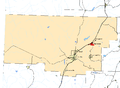
 Ironcounty ut.png 989 × 541; 24 KB
-
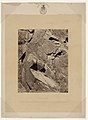
 Mountain Meadows BHoU-p550.png 1 760 × 3 126; 156 KB
-
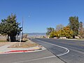 North on SR-274 at jct with SR-271 in Parowan, Utah, Oct 16.jpg 2 592 × 1 944; 2,43 MB
-
 P1030747 - Flickr - R. W. Rynerson.jpg 3 648 × 2 432; 3,62 MB
-
 Parowan, UT 84761, USA - panoramio (1).jpg 3 264 × 2 448; 2,7 MB
-
 Southern Utah map c. 1857, Bancroft p. 550.PNG 332 × 563; 43 KB
-
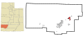
 UTMap-doton-Parowan.PNG 238 × 300; 18 KB


.jpg)


Categorie:
- Cities in Utah
- Populated places in Iron County, Utah
- County seats in Utah
- Parowan Valley
- Locations along Interstate 15 in Iron County, Utah
- Locations along U.S. Route 91 in Utah (1926-1974) in Iron County, Utah
- Locations along Utah State Route 76 (1968-1969)
- Locations along Utah State Route 127 (1933-1953)
- Locations along Utah State Route 143 in Iron County, Utah
- Locations along Utah State Route 271
- Locations along Utah State Route 274