Category:Piringsdorf
Salta a la navigazzion
Và a cercà
comune austriaco  | |||||
| Carega su un fail audio / video | |||||
| L'è un(a) |
| ||||
|---|---|---|---|---|---|
| Sit | Distreto de Oberpullendorf, Burgenland, Austria | ||||
| Léngoa ofiçiâ | |||||
| Popolazzion |
| ||||
| Area |
| ||||
| Altezza in sul mar |
| ||||
| sit ofizzial | |||||
 | |||||
Sotocategorie
Quella categoria chì la gh'ha 3 sot-categorie chì de sota, su un numer complessiv de 3.
Fail in la categoria "Piringsdorf"
Quella categoria chì la gh'ha denter 4 i fail riportad chì de sota, su un total de 4.
-
 AUT Piringsdorf COA.jpg 209 × 240; 16 KByte
-
 Map at piringsdorf.png 400 × 240; 3 KByte
-
 Piringsdorf im Bezirk OP.png 645 × 645; 24 KByte
-
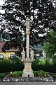 Piringsdorf MariaImmaculata.jpg 3 056 × 4 592; 3,88 MByte


