Category:Planès
Zur Navigation springen
Zur Suche springen
English: Planès (département of Pyrénées-Orientales, Languedoc-Roussillon région, France)
Français : Planès (Pyrénées-Orientales, Languedoc-Roussillon, France)
französische Gemeinde   | |||||
| Medium hochladen | |||||
| Aussprache (Audiodatei) | |||||
|---|---|---|---|---|---|
| Ist ein(e) | |||||
| Ort | |||||
| Leiter der Regierung oder Verwaltung |
| ||||
| Einwohnerzahl |
| ||||
| Fläche |
| ||||
| offizielle Website | |||||
 | |||||
Unterkategorien
Es werden 7 von insgesamt 7 Unterkategorien in dieser Kategorie angezeigt:
In Klammern die Anzahl der enthaltenen Kategorien (K), Seiten (S), Dateien (D)
G
- Gare de Planès (3 D)
M
- Maps of Planès (5 D)
P
R
- Roc del Boc (1 D)
T
- Torre d'Eina (3 D)
- Town hall of Planès (1 D)
Medien in der Kategorie „Planès“
Folgende 18 Dateien sind in dieser Kategorie, von 18 insgesamt.
-
 66142-Planès-Routes-Hydro.png 3.507 × 2.480; 914 KB
-
 66142-Planès-Sols.png 3.270 × 2.598; 1,61 MB
-
 El Castell el 1812.png 815 × 673; 999 KB
-
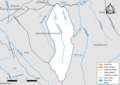
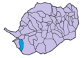
 Map commune FR insee code 66142.png 756 × 605; 60 KB
-
 Pic de l'Orri - P1030562.jpg 4.320 × 3.240; 5,35 MB
-
 Planes castell.JPG 1.600 × 1.200; 581 KB
-
 Planes castell1.JPG 1.600 × 1.200; 516 KB
-
 Planes vue.JPG 1.600 × 1.200; 661 KB
-
 Planes vue2.JPG 1.600 × 1.200; 580 KB
-
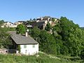
 Planès - panoramio.jpg 1.200 × 900; 401 KB
-
 Planès de Dalt - P1030571.jpg 4.320 × 3.240; 5,39 MB
-
 Planès de Dalt - P1030572.jpg 4.320 × 3.240; 5,72 MB
-
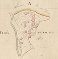
 Planès de Dellà el 1812.png 280 × 278; 154 KB
-
 Planès de l'Església el 1812.png 260 × 346; 154 KB
-
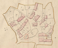
 Planès del Mig el 1812.png 355 × 358; 207 KB
-
 Planès en el Conflent.png 862 × 600; 57 KB
-
 Population - Municipality code 66142.svg 475 × 355; 12 KB
-
 Serrat de les Esques - P1030561.jpg 4.320 × 3.240; 5,24 MB


