Category:Pocomoke River
Zur Navigation springen
Zur Suche springen
Fluss in den US-Bundesstaaten Delaware, Maryland und Virginia  | |||||
| Medium hochladen | |||||
| Ist ein(e) | |||||
|---|---|---|---|---|---|
| Ort | |||||
| Länge |
| ||||
| Mündet in |
| ||||
| Nebenfluss |
| ||||
 | |||||
Medien in der Kategorie „Pocomoke River“
Folgende 20 Dateien sind in dieser Kategorie, von 20 insgesamt.
-

-
-
 Watershed work plan Dividing Creek watershed, Worcester, Wicomico and Somerset Counties, Maryland (IA CAT81313834).pdf 987 × 1.481, 56 Seiten; 2,45 MB
-
 Forested wetland (7508455504).jpg 1.970 × 1.477; 863 KB
-
 On The Banks Of Pocomoke River (52470203525).jpg 5.378 × 3.585; 3,6 MB
-
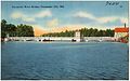
 Pocomoke Bridge (21440718648).jpg 1.152 × 864; 216 KB
-
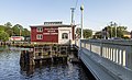
 Pocomoke City Bridge, a drawbridge completed in 1920, Pocomoke City, Maryland LCCN2011635448.tif 6.103 × 4.746; 165,76 MB
-
 Pocomoke City Bridge, built in 1920 in Worcester County, Maryland LCCN2011631722.tif 6.841 × 5.462; 213,83 MB
-
 Pocomoke City Bridge, built in 1920 on Maryland's Eastern Shore LCCN2011632555.tif 5.683 × 4.566; 148,5 MB
-
 Pocomoke River at Snow Hill MD1.jpg 5.392 × 3.277; 12,71 MB
-
 Pocomoke River at Snow Hill MD2.jpg 5.332 × 3.555; 13,73 MB
-
 Pocomoke River at Snow Hill MD3.jpg 5.472 × 3.648; 19,64 MB
-
 Pocomoke River Bridge, Pocomoke City, Md (70291).jpg 3.306 × 2.078; 2,82 MB
-
 Pocomoke River Sunset - Flickr - aparlette.jpg 3.602 × 5.403; 5,74 MB
-
 PocomokeCityBridge.jpg 5.184 × 3.888; 4,49 MB
-
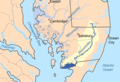 Pocomokemap (cropped).png 400 × 273; 34 KB
-
 Pocomokemap.png 500 × 566; 69 KB
-

-
 View along Pocomoke River, Pocomoke City, Md (70296).jpg 3.309 × 2.092; 3,21 MB
-
 Yacht Wharf, Pocomoke Park, Pocomoke City, Md (72884).jpg 3.288 × 2.092; 3,14 MB


.jpg)
.jpg)
.jpg)


.jpg)


.png)
.jpg)
.jpg)