Category:Podington
Aller à la navigation
Aller à la recherche
village britannique  | |||||
| Téléverser des médias | |||||
| Nature de l’élément | |||||
|---|---|---|---|---|---|
| Lieu | Bedford, Bedfordshire, Angleterre de l'Est, Angleterre | ||||
 | |||||
English: Podington is a village and civil parish in northwest Bedfordshire, England. The village is in the Borough of Bedford about 10 miles (16 km) northwest of Bedford town and about 1.2 miles (2 km) from the county boundary with Northamptonshire.
Sous-catégories
Cette catégorie comprend 6 sous-catégories, dont les 6 ci-dessous.
Média dans la catégorie « Podington »
Cette catégorie comprend 100 fichiers, dont les 100 ci-dessous.
-
 18th century stone houses in Podington - geograph.org.uk - 528743.jpg 640 × 479 ; 117 kio
-
 A view of the road into Farndish - geograph.org.uk - 6157424.jpg 1 600 × 1 066 ; 480 kio
-
 Airfield Road towards Santa Pod - geograph.org.uk - 6161289.jpg 1 600 × 1 066 ; 205 kio
-
 American war memorial in Poddington Church - geograph.org.uk - 6161292.jpg 1 066 × 1 600 ; 205 kio
-

-
 Boathouse at Hinwick Hall - geograph.org.uk - 314311.jpg 640 × 480 ; 162 kio
-
 Bridleway down towards the conifers - geograph.org.uk - 6158720.jpg 1 600 × 1 066 ; 430 kio
-
 Bridleway towards Irchester Road - geograph.org.uk - 6161274.jpg 1 600 × 1 066 ; 416 kio
-
 Byway following the course of the Roman Road - geograph.org.uk - 6157394.jpg 1 600 × 1 066 ; 510 kio
-
 Byway to the Irchester Road - geograph.org.uk - 6161285.jpg 1 600 × 1 066 ; 573 kio
-
 Byway to the Irchester Road - geograph.org.uk - 6305746.jpg 1 600 × 1 066 ; 533 kio
-
 Byway to Wymington - geograph.org.uk - 6161284.jpg 1 600 × 1 066 ; 419 kio
-
 Byway towards Poddington - geograph.org.uk - 6157919.jpg 1 600 × 1 066 ; 569 kio
-
 Chain Spinney and farmland - geograph.org.uk - 6161290.jpg 1 600 × 1 066 ; 430 kio
-
 Cockle Spinney - geograph.org.uk - 6150250.jpg 1 600 × 1 066 ; 456 kio
-
 Entrance to Santa Pod Raceway - geograph.org.uk - 3819713.jpg 640 × 456 ; 53 kio
-
 Farndish - geograph.org.uk - 5113808.jpg 640 × 481 ; 563 kio
-
 Farndish, Irchester Road - geograph.org.uk - 5113842.jpg 640 × 427 ; 485 kio
-
 Footpath by Hall Lane Spinney - geograph.org.uk - 6157398.jpg 1 600 × 1 066 ; 501 kio
-
 Footpath into Poddington - geograph.org.uk - 6161306.jpg 1 600 × 1 066 ; 318 kio
-
 Footpath through Hinwick - geograph.org.uk - 6157973.jpg 1 600 × 1 066 ; 459 kio
-
 Footpath to Farndish - geograph.org.uk - 6157986.jpg 1 600 × 1 066 ; 345 kio
-
 Footpath to Forty FootLane - geograph.org.uk - 6166799.jpg 1 600 × 1 066 ; 501 kio
-
 Footpath to Hall Lane - geograph.org.uk - 6157988.jpg 1 600 × 1 066 ; 327 kio
-
 Footpath to Hall Lane - geograph.org.uk - 6157991.jpg 1 600 × 1 066 ; 396 kio
-
 Footpath to Hinwick Lodge Farm - geograph.org.uk - 6167276.jpg 1 600 × 1 066 ; 447 kio
-
 Footpath to Hinwick Lodge Farm - geograph.org.uk - 6167280.jpg 1 600 × 1 066 ; 433 kio
-
 Footpath to Poddington - geograph.org.uk - 6157427.jpg 1 600 × 1 066 ; 558 kio
-
 Footpath to Poddington - geograph.org.uk - 6167271.jpg 1 600 × 1 066 ; 467 kio
-
 Footpath to Wymington - geograph.org.uk - 6166686.jpg 1 600 × 1 066 ; 431 kio
-
 Footpath towards the solar park - geograph.org.uk - 6167239.jpg 1 600 × 1 066 ; 529 kio
-
 Ford at Farndish - geograph.org.uk - 3020108.jpg 3 264 × 2 448 ; 5,06 Mio
-
 Forty Foot Lane - geograph.org.uk - 4851549.jpg 640 × 640 ; 127 kio
-
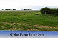 Glebe Farm Solar Park from the information board - geograph.org.uk - 6166703.jpg 1 600 × 1 066 ; 362 kio
-
 Glebe Farm Solar Park information board - geograph.org.uk - 6166700.jpg 1 600 × 1 200 ; 678 kio
-
 Great Hayes Wood - geograph.org.uk - 4851554.jpg 640 × 640 ; 171 kio
-
 Hedgerow and cereals - geograph.org.uk - 6157386.jpg 1 600 × 1 066 ; 483 kio
-
 Manor Farm Farndish - geograph.org.uk - 6157844.jpg 1 600 × 1 066 ; 461 kio
-
 Motte and Bailey and sheep - geograph.org.uk - 6161304.jpg 1 600 × 1 066 ; 312 kio
-
 New woodland by the bridleway - geograph.org.uk - 6161276.jpg 1 600 × 1 066 ; 371 kio
-
 On the path to Wymington - geograph.org.uk - 6166705.jpg 1 600 × 1 066 ; 742 kio
-
 Paddock by Dungee Corner - geograph.org.uk - 6150192.jpg 1 600 × 1 066 ; 554 kio
-
 Pheasants near Hinwick Lodge Farm - geograph.org.uk - 528833.jpg 640 × 480 ; 166 kio
-
 Poddington Cricket ground - geograph.org.uk - 6157992.jpg 1 600 × 1 066 ; 310 kio
-
 Poddington War Memorial - geograph.org.uk - 6161299.jpg 1 600 × 1 200 ; 620 kio
-
 Podington Cricket Club - geograph.org.uk - 5714011.jpg 6 251 × 4 172 ; 4,16 Mio
-
 Podington Cricket Club - geograph.org.uk - 5714013.jpg 6 681 × 4 459 ; 6,9 Mio
-
 Podington Garden Centre - geograph.org.uk - 528751.jpg 640 × 480 ; 140 kio
-
 Public footpath through the cottages to Hinwick Lodge Farm - geograph.org.uk - 6161298.jpg 1 600 × 1 066 ; 293 kio
-
 Public footpath to Hinwick - geograph.org.uk - 6150208.jpg 1 600 × 1 066 ; 522 kio
-
 Public footpath to Hinwick - geograph.org.uk - 6157397.jpg 1 600 × 1 066 ; 391 kio
-
 Public footpath to the Forty Acre Wood - geograph.org.uk - 6157985.jpg 1 600 × 1 066 ; 528 kio
-
 Public footpath to Wymington Road - geograph.org.uk - 6161310.jpg 1 600 × 1 066 ; 429 kio
-
 Ripe wheat ready to harvest, Podington - geograph.org.uk - 528805.jpg 640 × 480 ; 114 kio
-
 Seasonal byway closed by bad weather, near Bozeat - geograph.org.uk - 532304.jpg 640 × 480 ; 313 kio
-
 Small wood at the field end - geograph.org.uk - 6167262.jpg 1 600 × 1 066 ; 721 kio
-
 Spinney across the field - geograph.org.uk - 6157960.jpg 1 600 × 1 066 ; 349 kio
-
 Spinney across the fields - geograph.org.uk - 6150209.jpg 1 600 × 1 066 ; 512 kio
-
 St Mary's churchyard - geograph.org.uk - 6161300.jpg 1 066 × 1 600 ; 348 kio
-
 St Michael's Church, Farndish - geograph.org.uk - 5113839.jpg 640 × 481 ; 531 kio
-
 St Michael's Farndish - geograph.org.uk - 6157418.jpg 1 600 × 1 200 ; 607 kio
-
 Stand of trees in the field - geograph.org.uk - 6157401.jpg 1 600 × 1 066 ; 361 kio
-
 Stream by the byway - geograph.org.uk - 6161287.jpg 1 600 × 1 066 ; 565 kio
-
 Stubble left after wheat harvest, Podington - geograph.org.uk - 528796.jpg 480 × 640 ; 319 kio
-
 Telephone mast near Farndish - geograph.org.uk - 6157850.jpg 1 600 × 1 066 ; 345 kio
-
 Thatched cottages in Podington - geograph.org.uk - 528746.jpg 640 × 480 ; 99 kio
-
 The Church of St Michaels and All Angels - geograph.org.uk - 5113838.jpg 640 × 480 ; 538 kio
-
 The edge of Great Hayes Wood - geograph.org.uk - 6166708.jpg 1 600 × 1 066 ; 433 kio
-
 The Grove - geograph.org.uk - 6157963.jpg 1 600 × 1 066 ; 427 kio
-
 The path between Darnell's Dene and the solar panels - geograph.org.uk - 6166706.jpg 1 600 × 1 066 ; 495 kio
-
 Three Shires Way along Forty Foot Lane - geograph.org.uk - 6150255.jpg 1 600 × 1 066 ; 611 kio
-
 Track by Cockle Spinney - geograph.org.uk - 6150206.jpg 1 600 × 1 066 ; 661 kio
-
 Track to the Irchester Road - geograph.org.uk - 6157930.jpg 1 600 × 1 066 ; 576 kio
-
 Track towards the solar farm - geograph.org.uk - 6167255.jpg 1 600 × 1 066 ; 521 kio
-
 Tree Avenue on Dungee to Hinwick Road - geograph.org.uk - 314287.jpg 640 × 480 ; 149 kio
-
 Trees by the stream - geograph.org.uk - 6167267.jpg 1 600 × 1 066 ; 433 kio
-
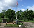 USAAF 92nd Bomber Group Memorial - geograph.org.uk - 5679271.jpg 3 110 × 2 550 ; 1,32 Mio
-
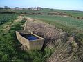 Water Trough beside the Byway north of Poddington - geograph.org.uk - 315530.jpg 640 × 480 ; 143 kio
-
 Wellwound Plantation and sheep - geograph.org.uk - 6161307.jpg 1 600 × 1 066 ; 325 kio
-
 Woodland by Farndish - geograph.org.uk - 6161280.jpg 1 600 × 1 066 ; 515 kio
-
 Woodland by the Roman Road - geograph.org.uk - 6157389.jpg 1 600 × 1 066 ; 343 kio
-
 Byway and Footpath Junction north of Poddington - geograph.org.uk - 315536.jpg 640 × 480 ; 140 kio
-
 Byway in Brownage Wood - geograph.org.uk - 393105.jpg 640 × 480 ; 108 kio
-
 Byway to Wymington - geograph.org.uk - 315539.jpg 640 × 480 ; 179 kio
-
 Car parking lot, Santa Pod dragstrip - geograph.org.uk - 393102.jpg 640 × 480 ; 83 kio
-
 Field of rough grass near Great Hayes Wood - geograph.org.uk - 527377.jpg 640 × 480 ; 222 kio
-

-
 Footpath through wheat to Hinwick Lodge Farm - geograph.org.uk - 528841.jpg 640 × 480 ; 288 kio
-
 Footpath to Wymington - geograph.org.uk - 315538.jpg 640 × 480 ; 178 kio
-
 Grass field with hawthorn hedge and oak trees - geograph.org.uk - 528839.jpg 640 × 480 ; 190 kio
-
 Harvest Gathered in at Dungee Corner - geograph.org.uk - 298013.jpg 640 × 480 ; 96 kio
-
 Hedged wheat field, spinney beyond, by Podington - geograph.org.uk - 528799.jpg 640 × 480 ; 219 kio
-
 Maize for game birds, by wheat field - geograph.org.uk - 527395.jpg 480 × 640 ; 199 kio
-
 Oak and ash trees near Hinwick Lodge Farm - geograph.org.uk - 527301.jpg 640 × 480 ; 227 kio
-
 Ornamental Canals and Entrance to Hinwick Hall - geograph.org.uk - 314305.jpg 640 × 480 ; 138 kio
-
 Podington Post Office and High Street - geograph.org.uk - 278570.jpg 640 × 480 ; 113 kio
-
 Public footpath into Great Hayes Wood - geograph.org.uk - 528810.jpg 640 × 480 ; 230 kio
-
 Roman Road to Irchester - geograph.org.uk - 404182.jpg 640 × 480 ; 71 kio
-
-
 White's Barn near Farndish - geograph.org.uk - 315540.jpg 640 × 480 ; 128 kio


_aerodrome,_disused,_aerial_-_geograph.org.uk_-_3515887.jpg)


