Category:Political maps of Ukraine
Vai alla navigazione
Vai alla ricerca
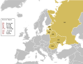
Paesi d’Europa: Albania · Austria · Azerbaigian‡ · Belgio · Bielorussia · Bosnia ed Erzegovina · Bulgaria · Cipro‡ · Croazia · Danimarca · Estonia · Finlandia · Francia‡ · Georgia‡ · Germania · Grecia · Irlanda · Islanda · Italia · Kazakistan‡ · Lettonia · Moldavia · Montenegro · Norvegia · Paesi Bassi‡ · Polonia · Portogallo‡ · Regno Unito · Repubblica Ceca · Romania · Russia‡ · Serbia · Slovenia · Spagna‡ · Svezia · Svizzera · Turchia‡ · Ucraina · Ungheria
Entità particolari: Jersey – Entità a riconoscimento limitato: Kosovo · Ossezia del Sud‡
‡: in parte situato in Europa
Entità particolari: Jersey – Entità a riconoscimento limitato: Kosovo · Ossezia del Sud‡
‡: in parte situato in Europa
Sottocategorie
Questa categoria contiene le 7 sottocategorie indicate di seguito, su un totale di 7.
File nella categoria "Political maps of Ukraine"
Questa categoria contiene 93 file, indicati di seguito, su un totale di 93.
-
 1 Блок Наша Україна.PNG 1 651 × 1 142; 315 KB
-
 1 КПУ.PNG 1 651 × 1 142; 294 KB
-
 2008 Ukraine mine collapse.jpg 1 181 × 825; 93 KB
-
 Donbass i Vojsko Donskoe - EN.png 1 431 × 1 340; 122 KB
-
 Euromaidan Protests.png 1 198 × 792; 157 KB
-
 Euromaidan RSA occupations.png 645 × 405; 72 KB
-
 Inaccurate historical map of Ukrainian borders.jpg 1 881 × 1 266; 557 KB
-
 Johnson, A.J. Europe. 1864.D.Little Russia.jpg 1 172 × 770; 194 KB
-
 Johnson, A.J. Europe. 1864.D.South Russia.jpg 1 520 × 1 228; 478 KB
-
 Karte der Ukraine.png 4 844 × 3 255; 2,88 MB
-
 Karte Ukraine.png 1 181 × 825; 603 KB
-
 Kharkiv Oblast UPA.svg 1 546 × 1 038; 885 KB
-
 Lypa.png 793 × 648; 338 KB
-
 Map of Ukraine Livoberezzhya.png 800 × 559; 132 KB
-
 Map of Ukraine NAKBU.png 2 000 × 1 371; 362 KB
-
 Map of Ukraine political Crimea.png 800 × 559; 134 KB
-
 Map of Ukraine political Edisan.png 800 × 559; 133 KB
-
 Map of Ukraine political enwiki.png 1 417 × 990; 310 KB
-
 Map of Ukraine political eswiki.png 1 417 × 990; 940 KB
-
 Map of Ukraine political Galicia.png 800 × 559; 136 KB
-
 Map of Ukraine political Karpatskyi raion.png 800 × 559; 161 KB
-
 Map of Ukraine political Maeotida.png 800 × 559; 136 KB
-
 Map of Ukraine political Metalurgiia.png 800 × 559; 120 KB
-
 Map of Ukraine political Moldavia.png 800 × 559; 163 KB
-
 Map of Ukraine political Podolia.png 800 × 559; 133 KB
-
 Map of Ukraine political simple blank.png 1 280 × 878; 134 KB
-
 Map of Ukraine political simple blank.svg 700 × 480; 149 KB
-
 Map of Ukraine political simple Budzak.png 800 × 559; 138 KB
-
 Map of Ukraine political simple city Nova Kakhovka.png 1 181 × 825; 19 KB
-
 Map of Ukraine political simple Krim alternative.png 1 181 × 825; 19 KB
-
 Map of Ukraine political simple no gas in dispute 2009.PNG 1 181 × 825; 33 KB
-
 Map of Ukraine political simple Oblast Charkiw.png 1 200 × 799; 220 KB
-
 Map of Ukraine political simple Oblast Cherson.png 2 466 × 1 749; 202 KB
-
 Map of Ukraine political simple Oblast Czernowitz.png 2 466 × 1 749; 203 KB
-
 Map of Ukraine political simple Oblast Dnipropetrowsk.png 2 466 × 1 749; 203 KB
-
 Map of Ukraine political simple Oblast Donezk.png 1 200 × 799; 140 KB
-
 Map of Ukraine political simple Oblast Kiew.png 2 466 × 1 749; 204 KB
-
 Map of Ukraine political simple Oblast Kirowohrad.png 2 466 × 1 749; 203 KB
-
 Map of Ukraine political simple Oblast Krim.png 2 466 × 1 749; 202 KB
-
 Map of Ukraine political simple Oblast Lemberg.png 2 466 × 1 749; 282 KB
-
 Map of Ukraine political simple Oblast Mykolajiw.png 2 466 × 1 749; 283 KB
-
 Map of Ukraine political simple Oblast Poltawa.png 2 466 × 1 749; 283 KB
-
 Map of Ukraine political simple Oblast Rivne.png 2 466 × 1 749; 282 KB
-
 Map of Ukraine political simple Oblast Saporischja.png 2 466 × 1 749; 283 KB
-
 Map of Ukraine political simple Oblast Schytomyr.png 2 466 × 1 749; 282 KB
-
 Map of Ukraine political simple Oblast Sumy.png 2 466 × 1 749; 282 KB
-
 Map of Ukraine political simple Oblast Ternopil.png 2 466 × 1 749; 282 KB
-
 Map of Ukraine political simple Oblast Transkarpatien.png 2 466 × 1 749; 283 KB
-
 Map of Ukraine political simple Oblast Tscherkasy.png 2 466 × 1 749; 204 KB
-
 Map of Ukraine political simple Oblast Tschernihiw.png 2 466 × 1 749; 282 KB
-
 Map of Ukraine political simple Oblast Wolhynien.png 2 466 × 1 749; 282 KB
-
 Map of Ukraine political simple Oblast Wynnyzja.png 2 466 × 1 749; 282 KB
-
 Map of Ukraine political Snakes-Is.png 800 × 559; 135 KB
-
 Map of Ukraine political Taurida.png 800 × 559; 135 KB
-
 Map of Ukraine political Volhynia (1).png 800 × 559; 149 KB
-
 Map of Ukraine political Volhynia.png 800 × 559; 134 KB
-
 Map of Ukraine with Cities.png 4 844 × 3 255; 2,72 MB
-
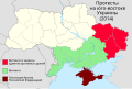
 Map pro-Ukrainean and pro-Russian protests in the Ukraine 2014.png 2 147 × 1 442; 477 KB
-
 Mapa politico de Ucrania (en español).png 800 × 559; 344 KB
-
 OK Північ.png 512 × 351; 52 KB
-
 Political map of Eastern Europe according UN mk.svg 680 × 520; 529 KB
-
 Political map of Eastern Europe mk.svg 680 × 520; 527 KB
-
 Politiek Oekraïne.png 800 × 558; 296 KB
-
 Pro-russia-protests.png 2 000 × 1 455; 267 KB
-
 Pro-ukraine-protests.png 2 000 × 1 455; 275 KB
-
 Prorussian 2008 2014.png 770 × 568; 138 KB
-
 PSM V53 D747 Cephalic index map of eastern europe.png 1 577 × 1 556; 566 KB
-
 PUTIN UND DIE UKRAINE.jpg 1 024 × 745; 678 KB
-
 Recognition of UPA in Ukrainian regions.svg 1 546 × 1 038; 885 KB
-
 Regional Administration seizures in Ukraine.svg 550 × 400; 701 KB
-
 Rossiya Shegini.jpg 800 × 533; 210 KB
-
 RSA by pro-Russians.png 2 000 × 1 455; 432 KB
-
 Sloboda Ukraine.png 1 172 × 807; 418 KB
-
 Svoboda 2006.png 1 181 × 878; 126 KB
-
 Svoboda 2007.png 1 181 × 1 000; 85 KB
-
 Svoboda 2010 election.png 1 181 × 863; 86 KB
-
 Svoboda 2010 President.png 1 181 × 861; 131 KB
-
 UA Presidents by state of of birth.png 2 000 × 1 346; 437 KB
-
 Ukraina map polish.png 1 417 × 990; 128 KB
-
 Ukraina.png 1 181 × 825; 497 KB
-
 Ukraine 1918 de.jpg 1 597 × 1 181; 622 KB
-
 Ukraine Base Map.png 1 104 × 697; 477 KB
-
 Ukraine DBR.svg 700 × 480; 393 KB
-
 Ukraine KIIS-Regional-division.png 1 181 × 825; 33 KB
-
 Ukraine NABU.svg 656 × 443; 332 KB
-
 Ukraine Political Regions.png 1 181 × 825; 62 KB
-
 Ukraine proposal administrative divisions (2013) by Serhiy Hrynevetsky.png 1 176 × 820; 71 KB
-
 Ukraine should join Russia poll - 8-18 February 2014.svg 550 × 380; 768 KB
-
 Карта вільних сайтів облрад.jpg 1 200 × 799; 342 KB
-

-
 Протести в областях України new.png 1 024 × 682; 204 KB
-
 Протесты на юго-востоке Украины (2014).svg 512 × 344; 338 KB
-
 Русская весна 2014.svg 1 546 × 1 038; 545 KB


.png)


.png)


_by_Serhiy_Hrynevetsky.png)


.svg)

.svg)
