Category:Pontllanfraith
Vai alla navigazione
Vai alla ricerca
village in United Kingdom   | |||||
| Carica un file multimediale | |||||
| Istanza di | |||||
|---|---|---|---|---|---|
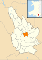
| Luogo | Caerphilly, Galles | ||||
| Popolazione |
| ||||
| Superficie |
| ||||
 | |||||
Cymraeg: Pentref mawr ym mwrdeisdref sirol Caerffili yw Pontllan-fraith, hefyd Pontllanfraith. Saif yn Nyffryn Sirhywi, gerllaw tref Coed Duon ac ar Afon Sirhywi.
English: Pontllanfraith is a large village located in the Sirhowy Valley in Caerphilly county borough, south Wales, within the historic boundaries of Monmouthshire. It is situated adjacent to the town of Blackwood, with the River Sirhowy passing through both locations. The village includes the communities of the Penllwyn, Springfield and The Bryn.
Sottocategorie
Questa categoria contiene le 2 sottocategorie indicate di seguito, su un totale di 2.
B
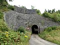
- Bryn Tunnel (1 F)
S
File nella categoria "Pontllanfraith"
Questa categoria contiene 200 file, indicati di seguito, su un totale di 323.
(pagina precedente) (pagina successiva)-
 2010 Wales Caerphilly Community Pontllanfraith map.svg 512 × 725; 375 KB
-
 2024 Wales Caerphilly Community Pontllanfraith map.svg 512 × 725; 345 KB
-
 A4048 north of Pontllanfraith - geograph.org.uk - 2750962.jpg 640 × 454; 48 KB
-

-
 A472 near Pontllanfraith - geograph.org.uk - 2247495.jpg 640 × 480; 72 KB
-

-

-
 A472, Crown Roundabout - geograph.org.uk - 3135510.jpg 640 × 480; 448 KB
-
 A472, Pontllanfraith - geograph.org.uk - 3135514.jpg 640 × 480; 466 KB
-

-

-

-
 Approach to Pontllanfraith House - geograph.org.uk - 5509876.jpg 4 608 × 3 456; 3,82 MB
-

-

-
 Arrow Ford Pontllanfraith - geograph.org.uk - 2345628.jpg 640 × 465; 77 KB
-
 Arrow Ford, Pontllanfraith - geograph.org.uk - 2249762.jpg 640 × 469; 57 KB
-
 Bank of daffodils, Pontllanfraith - geograph.org.uk - 3789026.jpg 800 × 577; 111 KB
-

-
 Bend in the B4251, Pontllanfraith - geograph.org.uk - 5814079.jpg 800 × 787; 130 KB
-

-
 Bird in Hand pub, Pontllanfraith - geograph.org.uk - 2425887.jpg 640 × 596; 100 KB
-
 Blackwood Chainsaws, Gelligroes - geograph.org.uk - 2247430.jpg 640 × 601; 93 KB
-

-

-

-
 Bryn Road bungalows, Pontllanfraith - geograph.org.uk - 2425904.jpg 640 × 435; 72 KB
-

-
 Bryn Road houses, Pontllanfraith - geograph.org.uk - 2425892.jpg 640 × 453; 76 KB
-
 Bryn View, Pontllanfraith - geograph.org.uk - 2425933.jpg 640 × 403; 63 KB
-
 Brynhyfryd St, Blackwood - geograph.org.uk - 5509872.jpg 4 608 × 3 456; 3,87 MB
-
 Brynteg Avenue, Pontllanfraith - geograph.org.uk - 3615792.jpg 800 × 597; 106 KB
-

-
 Bus stops and bus, Bryn Rd, Pontllanfraith - geograph.org.uk - 5509920.jpg 4 608 × 3 456; 3,85 MB
-

-
 Candle Workshop, Gelligroes - geograph.org.uk - 2247471.jpg 640 × 480; 90 KB
-
 Car Park, Pontllanfraith - geograph.org.uk - 2780344.jpg 640 × 480; 63 KB
-

-

-

-

-

-

-
 Civic Centre Car Park, Pontllanfraith - geograph.org.uk - 1556126.jpg 640 × 480; 116 KB
-
 Civic Centre Drive at Pontllanfraith - geograph.org.uk - 838140.jpg 640 × 480; 95 KB
-
 Clos Trefin houses, Pontllanfraith - geograph.org.uk - 5820517.jpg 800 × 602; 161 KB
-

-
 Colin's Fish Bar, Pontllanfraith - geograph.org.uk - 2680928.jpg 640 × 480; 93 KB
-

-
 Corner of field near Twynfilkins Cottage - geograph.org.uk - 6015087.jpg 5 179 × 3 451; 4,46 MB
-

-

-

-
 Courthouse car park, Pontllanfraith - geograph.org.uk - 3615918.jpg 800 × 717; 166 KB
-
 CQD SOS We have struck an iceberg - geograph.org.uk - 2892372.jpg 640 × 480; 185 KB
-
 Crossroads, Gelli Lane and Gelligroes Rd, Pontllanfraith - geograph.org.uk - 5509926.jpg 4 608 × 3 456; 3,85 MB
-
 Cwm Braenar, Pontllanfraith - geograph.org.uk - 3073834.jpg 640 × 477; 60 KB
-
 Cwrt Pantycelyn, Pontllanfraith - geograph.org.uk - 2249779.jpg 640 × 496; 64 KB
-

-
-

-
 Daffodils in Pontllanfraith - geograph.org.uk - 361658.jpg 640 × 480; 92 KB
-
 Dan y Bryn, Pontllanfraith - geograph.org.uk - 5509935.jpg 4 608 × 3 456; 3,9 MB
-

-

-

-
 Divisional Police Headquarters, Blackwood - geograph.org.uk - 5509870.jpg 4 608 × 3 456; 3,8 MB
-
 Down Penllwyn Avenue, Pontllanfraith - geograph.org.uk - 5814156.jpg 800 × 744; 122 KB
-
 Duffryrn Clyd, Gelligroes - geograph.org.uk - 2247494.jpg 640 × 415; 65 KB
-

-

-
 Elim Baptist Church, Pontllanfraith - geograph.org.uk - 2345600.jpg 640 × 450; 71 KB
-
 Entrance to Blackwood Business Park - geograph.org.uk - 2247409.jpg 640 × 480; 82 KB
-

-
 Ex Servicemen's Club - geograph.org.uk - 361613.jpg 640 × 480; 86 KB
-
 Factory, Ponllanfraith - geograph.org.uk - 361668.jpg 640 × 480; 83 KB
-

-

-
 Flooring retailers, Pontllanfraith - geograph.org.uk - 2249784.jpg 640 × 480; 55 KB
-
 Footbridge over the A472 - geograph.org.uk - 3998264.jpg 1 600 × 1 064; 444 KB
-

-
 Footpath into Memorial Park Meadows, Pontllanfraith - geograph.org.uk - 5094463.jpg 5 184 × 3 456; 5,18 MB
-
 Footpath off Bryn Rd, Pontllanfraith - geograph.org.uk - 5509937.jpg 4 608 × 3 456; 3,99 MB
-
 Footpath to Blackwood Road, Pontllanfraith - geograph.org.uk - 4781777.jpg 5 174 × 3 446; 6,17 MB
-
 Forest Hill, Pontllanfraith - geograph.org.uk - 2425910.jpg 640 × 480; 73 KB
-

-

-

-
 Gate on path to Twynfilkins Farm - geograph.org.uk - 6015111.jpg 5 184 × 3 456; 7,51 MB
-
 Gate to Rhymney Valley Ridgeway Walk - geograph.org.uk - 5382199.jpg 5 179 × 3 451; 7,25 MB
-
 Geese at Glan-brynar Farm, Tir Philkins - geograph.org.uk - 4824968.jpg 5 179 × 3 451; 5,39 MB
-
 Gelli Lane, Pontllanfraith - geograph.org.uk - 2345681.jpg 640 × 519; 94 KB
-

-

-
 Gelligroes Mill - geograph.org.uk - 5390947.jpg 1 600 × 1 200; 558 KB
-
 Gelligroes mill - geograph.org.uk - 736957.jpg 638 × 475; 60 KB
-
 Gelligroes Mill near Pontllanfraith - geograph.org.uk - 3742841.jpg 1 024 × 768; 203 KB
-
 Gelligroes Mill, Pontllanfraith - geograph.org.uk - 2892390.jpg 640 × 480; 131 KB
-

-

-

-

-
 Gelligroes Road, Pontllanfraith - geograph.org.uk - 2345662.jpg 640 × 480; 65 KB
-
 Gelligroes Road, Pontllanfraith - geograph.org.uk - 5814160.jpg 720 × 800; 127 KB
-

-

-
 Glan-brynar Farm, Tir Philkins - geograph.org.uk - 4824956.jpg 5 179 × 3 451; 4,85 MB
-
-

-

-
-

-
 House in Blackwood Rd, Pontllanfraith - geograph.org.uk - 5509889.jpg 4 608 × 3 456; 3,85 MB
-
 House next to A472, Pontllanfraith - geograph.org.uk - 5978857.jpg 5 179 × 3 451; 4,5 MB
-

-

-
 Houses in Blackwood Rd, Pontllanfraith - geograph.org.uk - 5509883.jpg 4 608 × 3 456; 3,84 MB
-

-

-
 Houses, Tir Philkins - geograph.org.uk - 4825463.jpg 5 179 × 3 451; 4,48 MB
-
 InfoQuest, Pontllanfraith - geograph.org.uk - 2249363.jpg 640 × 460; 89 KB
-
 Islwyn Park, Llanarth Road, Pontllanfraith - geograph.org.uk - 4781904.jpg 5 179 × 3 451; 4,6 MB
-
 Islwyn Terrace, Pontllanfraith - geograph.org.uk - 3073928.jpg 640 × 392; 52 KB
-
 Ivor Arms Pontllanfraith - geograph.org.uk - 3073818.jpg 640 × 392; 48 KB
-
 Ivor Arms, Pontllanfraith - geograph.org.uk - 2345607.jpg 640 × 374; 54 KB
-

-

-
 Junction of Gelli Lane with the A4048 - geograph.org.uk - 5509923.jpg 4 608 × 3 456; 3,72 MB
-

-
 King David Tyres, Pontllanfraith - geograph.org.uk - 2249250.jpg 640 × 550; 77 KB
-
 Lane down to Wyllie from Tyle-gwyn - geograph.org.uk - 5198772.jpg 5 179 × 3 451; 6,67 MB
-
 Lane towards the B4251 in Pontllanfraith - geograph.org.uk - 5820601.jpg 800 × 704; 122 KB
-

-
 Left for Wyllie, Upper Gelligroes - geograph.org.uk - 2359627.jpg 640 × 461; 102 KB
-

-

-
 Libanus Road houses, Blackwood - geograph.org.uk - 2425822.jpg 640 × 534; 86 KB
-

-

-

-
 Maesteg bungalows, Pentwynmawr - geograph.org.uk - 2017235.jpg 640 × 388; 58 KB
-
 Manor Road, Pontllanfraith - geograph.org.uk - 2425877.jpg 640 × 480; 77 KB
-
 Marshfield Court, Pontllanfraith - geograph.org.uk - 5820280.jpg 800 × 628; 93 KB
-

-
 Memorial Park Meadows, Pontllanfraith - geograph.org.uk - 5101118.jpg 5 179 × 3 451; 4,64 MB
-

-

-

-
 Monkey-puzzle tree beside the path - geograph.org.uk - 2523695.jpg 640 × 480; 104 KB
-
 Mouth of Nant Brynar, Pontllanfraith - geograph.org.uk - 5128629.jpg 5 179 × 3 451; 4,65 MB
-

-
 Nant Brynar, Islwyn Park, Pontllanfraith - geograph.org.uk - 3074005.jpg 640 × 600; 117 KB
-
 Nant Philkins, Penmaen Road - geograph.org.uk - 4781630.jpg 5 184 × 3 451; 4,03 MB
-
 Nant-y-rhos, Pontllanfraith - geograph.org.uk - 2345747.jpg 640 × 484; 75 KB
-
 Nant-y-rhos, Pontllanfraith - geograph.org.uk - 5814270.jpg 780 × 800; 107 KB
-
 NCN Route 47 beside the A472 - geograph.org.uk - 2327119.jpg 2 816 × 2 112; 1,69 MB
-

-
 NNW along Gelli Lane, Pontllanfraith - geograph.org.uk - 5820344.jpg 751 × 800; 130 KB
-

-

-

-

-
 Old Bridge Court, Pontllanfraith - geograph.org.uk - 5820439.jpg 800 × 551; 93 KB
-

-

-

-
 Ordnance Survey Cut Mark - geograph.org.uk - 6189087.jpg 1 024 × 782; 340 KB
-
 Ordnance Survey Flush Bracket (S1340) - geograph.org.uk - 6189091.jpg 693 × 1 024; 237 KB
-
 Ordnance Survey Flush Bracket (S1341) - geograph.org.uk - 6189089.jpg 730 × 1 024; 334 KB
-

-
 Overdene, Pontllanfraith - geograph.org.uk - 5814262.jpg 800 × 581; 99 KB
-
 Pasture, above Pentwyn-mawr - geograph.org.uk - 4824340.jpg 5 179 × 3 451; 5,82 MB
-
 Path descending from Glanhowy Road, Wyllie - geograph.org.uk - 5917401.jpg 1 024 × 865; 453 KB
-
 Path from Glanhowy Road, Wyllie - geograph.org.uk - 5198708.jpg 5 179 × 3 451; 5,12 MB
-
 Path from Pontllanfraith to Blackwood - geograph.org.uk - 3615869.jpg 800 × 686; 188 KB
-

-
 Path to Cwm Philkins, Pontllanfraith - geograph.org.uk - 2249785.jpg 640 × 480; 129 KB
-

-
 Pen-llwyn Avenue, Pontllanfraith - geograph.org.uk - 5129659.jpg 5 179 × 3 451; 5,58 MB
-
 Penllwyn Avenue, Pontllanfraith - geograph.org.uk - 2249227.jpg 579 × 640; 77 KB
-
 Penllwyn Lane bus stops, Pontllanfraith - geograph.org.uk - 3615805.jpg 800 × 718; 179 KB
-
 Penllwyn Lane, Pontllanfraith - geograph.org.uk - 3615781.jpg 800 × 799; 181 KB
-

-
 Penybryn Terrace, Bryn Rd, Pontllanfraith - geograph.org.uk - 5509939.jpg 4 608 × 3 456; 4 MB
-

-
 Playground, Sir Harold Finch Memorial Park - geograph.org.uk - 5162089.jpg 5 184 × 3 456; 5,85 MB
-
 Plough Corner, Pontllanfraith - geograph.org.uk - 3074085.jpg 640 × 540; 80 KB
-
 Pond, Sir Harold Finch Memorial Park, Pontllanfraith - geograph.org.uk - 5101129.jpg 5 179 × 3 451; 4,65 MB
-

-
 Pontllanfraith - Former Mynyddislwyn Urban District Council Offices - 20210406122602.jpg 4 032 × 3 024; 4,25 MB
-
 Pontllanfraith - Garden Wall at Penllwyn - 20210406131604.jpg 4 032 × 3 024; 5,24 MB
-
-
 Pontllanfraith - Shangri-la - 20210406121816.jpg 4 032 × 3 024; 2,68 MB
-
 Pontllanfraith - War Memorial - 20210406123617.jpg 3 024 × 4 032; 5,22 MB
-
 Pontllanfraith boundary sign - geograph.org.uk - 2016959.jpg 606 × 640; 113 KB
-
 Pontllanfraith crossroads - geograph.org.uk - 5820400.jpg 800 × 659; 178 KB
-
-
 Pontllanfraith House - geograph.org.uk - 2240025.jpg 640 × 349; 70 KB
-
 Pontllanfraith Methodist Church - geograph.org.uk - 2680920.jpg 640 × 480; 119 KB
-
 Pontllanfraith Post Office - geograph.org.uk - 2249769.jpg 640 × 518; 89 KB


_-_geograph.org.uk_-_6189091.jpg)
_-_geograph.org.uk_-_6189089.jpg)


