Category:Queenstown-Lakes District
Zur Navigation springen
Zur Suche springen
Wikimedia-Kategorie | |||||
| Medium hochladen | |||||
| Ist ein(e) | |||||
|---|---|---|---|---|---|
| |||||
Unterkategorien
Es werden 33 von insgesamt 33 Unterkategorien in dieser Kategorie angezeigt:
In Klammern die Anzahl der enthaltenen Kategorien (K), Seiten (S), Dateien (D)
A
- Arrow River (New Zealand) (3 D)
B
- Bowen Peak (2 D)
- Mount Broome (2 D)
C
- Caples River (2 D)
- Cecil Peak (28 D)
D
F
- Forge Flat (2 D)
G
- Greenstone River (1 D)
K
- Mount Kuri (1 D)
L
- Lindis River (2 D)
- Luggate, New Zealand (2 D)
M
- Makarora (4 D)
- Motatapu River (1 D)
P
- Paradise, New Zealand (21 D)
Q
R
- The Red Bridge (New Zealand) (2 D)
- Route Burn (6 D)
S
- Siberia Stream (1 D)
T
- Mount Turner (New Zealand) (5 D)
W
Medien in der Kategorie „Queenstown-Lakes District“
Folgende 45 Dateien sind in dieser Kategorie, von 45 insgesamt.
-
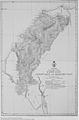 1884 map.jpg 2.699 × 4.111; 2,94 MB
-
 A view from the top. (51913677625).jpg 2.474 × 1.536; 3,78 MB
-
 After the Storm. (52233918607).jpg 5.300 × 3.443; 10,07 MB
-
 Arrow Junction, Crown Ranges, Queenstown District, New Zealand.jpg 6.222 × 3.804; 7,08 MB
-
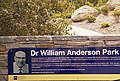 Dr William Anderson Park.jpg 3.288 × 2.207; 1,75 MB
-
 Lake Harris Routeburn Track New Zealand (150252437).jpeg 2.048 × 1.152; 1,03 MB
-
 Lake Wakatipu NZ.jpg 4.000 × 3.000; 4,17 MB
-
 Lake Wakatipu, Queenstown.jpg 4.000 × 3.000; 2,43 MB
-
 Landscape of Queenstown-Lakes District.jpg 3.901 × 2.028; 3,79 MB
-
 Marine Parade, Queenstown - panoramio (1).jpg 2.048 × 1.151; 715 KB
-
 Marine Parade, Queenstown - panoramio.jpg 2.048 × 1.151; 486 KB
-

-
 NZ - panoramio (1).jpg 5.072 × 1.376; 6,65 MB
-
 NZ - panoramio (2).jpg 5.056 × 1.312; 2,57 MB
-
 NZ - panoramio (3).jpg 1.200 × 1.600; 478 KB
-
 NZ - panoramio (4).jpg 5.024 × 1.360; 2,73 MB
-
 NZ - panoramio.jpg 4.000 × 3.000; 2,07 MB
-
 Oliver's Ridge (1)-1.jpg 4.560 × 3.648; 10,92 MB
-
 Paradise Road Glenorchy New Zealand 2018 (263481031).jpeg 2.048 × 306; 262 KB
-
 Procordulia grayi P1140501a.jpg 2.011 × 2.299; 1,42 MB
-
 Procordulia grayi P1140502b.jpg 2.489 × 2.749; 2 MB
-
 Queenstown New Zealand.jpg 3.024 × 4.032; 16,71 MB
-
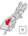 Queenstown-Lakes DC.png 289 × 375; 27 KB
-
 Queenstown-Lakes district in NZ 2017.svg 853 × 1.173; 569 KB
-
 River of rock (6706371557).jpg 4.000 × 3.000; 5,52 MB
-
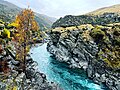 Roaring Meg, Kawarau Gorge.jpg 4.032 × 3.024; 8,34 MB
-
 Rocky Mountain Summit Wanaka (153460755).jpeg 2.048 × 1.361; 691 KB
-
 Seven Mile Point - panoramio.jpg 3.966 × 997; 2,34 MB
-
 Shadow of the Humboldt Mountains on the Richardson Range (6706361849).jpg 4.000 × 3.000; 2,75 MB
-
 Stefan Haworth photographer.jpg 1.000 × 667; 225 KB
-
 Summit of Ben Cruachan - panoramio.jpg 640 × 480; 55 KB
-
 The Route Burn (7731637114).jpg 4.000 × 3.000; 4,82 MB
-
 The View - Flickr - GregTheBusker.jpg 3.072 × 2.304; 1,37 MB
-
 Transport home (25213120289).jpg 1.800 × 1.200; 594 KB
-
 Treble Cone Ski Area - panoramio (1).jpg 10.000 × 6.228; 7,82 MB
-
 Treble Cone Ski Area - panoramio.jpg 4.928 × 3.264; 13,33 MB
-
 TSS Earnslaw Steamship Lake Whakatipu 2024 01.jpg 2.048 × 1.536; 378 KB
-
 TSS Earnslaw Steamship Lake Whakatipu 2024 02.jpg 2.048 × 1.536; 312 KB
-
 View From Crown Range Road (4678894950).jpg 3.008 × 2.000; 2,69 MB
-
 View From Crown Range Road (4678902022).jpg 3.008 × 2.000; 2,31 MB
-
 Windy Day Over Lake Hawea New Zealand (149475571).jpeg 2.048 × 1.152; 456 KB
-
 皇后镇 Queenstown House Bountique Hotel - panoramio.jpg 2.200 × 1.467; 2,08 MB
-
 皇后镇亨利街 Henry Street - panoramio.jpg 2.200 × 1.419; 1,73 MB
-
 皇后镇港口 - panoramio.jpg 2.200 × 1.467; 1,65 MB
-
 皇后镇港口附近 - panoramio.jpg 2.200 × 1.446; 2,59 MB

.jpg)
.jpg)


.jpeg)


.jpg)

_-_panoramio.jpg)
.jpg)

-1.jpg)


.jpg)

.jpeg)
.jpg)


.jpg)

.jpg)


.jpg)
.jpg)
.jpeg)


.jpg)
.jpg)
.jpg)
.jpeg)
.jpg)