Category:Regions of Alaska
Zur Navigation springen
Zur Suche springen
Bundesstaaten der Vereinigten Staaten: Alaska · Arizona · Arkansas · Connecticut · Florida · Idaho · Kalifornien · Kentucky · Louisiana · Maryland · Massachusetts · Montana · Nevada · New Jersey · New Mexico · New York · North Carolina · Ohio · Oklahoma · Oregon · Pennsylvania · South Dakota · Tennessee · Texas · Utah · Virginia · Washington · Wisconsin · Wyoming
Wikimedia-Kategorie | |||||
| Medium hochladen | |||||
| Ist ein(e) | |||||
|---|---|---|---|---|---|
| Kategorie kombiniert die Themen | |||||
| Alaska | |||||
Bundesstaat der Vereinigten Staaten von Amerika .jpg) someja da satełite in zuño     .svg)  | |||||
| Aussprache (Audiodatei) | |||||
| Ist ein(e) | |||||
| Ist Teil von | |||||
| Ort |
| ||||
| Liegt am oder im Gewässer | |||||
| Hauptstadt | |||||
| Gesetzgebende Körperschaft | |||||
| Exekutivorgan | |||||
| Höchstes Gericht | |||||
| Amtssprache |
| ||||
| Hymne |
| ||||
| Leiter der Regierung oder Verwaltung |
| ||||
| Datum der Gründung, Erstellung, Entstehung, Erbauung |
| ||||
| Höchster Punkt | |||||
| Einwohnerzahl |
| ||||
| Fläche |
| ||||
| Höhe über dem Meeresspiegel |
| ||||
| Ersetzt |
| ||||
| Verschieden von | |||||
| Höchsttemperatur |
| ||||
| Historische Tiefsttemperatur |
| ||||
| offizielle Website | |||||
 | |||||
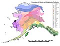
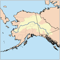
There is no general official classification of the regions of Alaska. There is a rough consensus for five or six regions, but no uniformity in their exact delineation. For classification on Commons, we use the scheme of the Alaska Regions identifier map, which divides along borough and census area boundaries. Other delineations are possible and maps illustrating these are welcome additions to this category. Please put illustrations of particular geographic features in the individual regions or their subcategories.

Magenta - Northern Alaska
Yellow - Interior Alaska
Blue - Southwest Alaska
Red - South-central Alaska
Green - Southeast Alaska
Unterkategorien
Es werden 8 von insgesamt 8 Unterkategorien in dieser Kategorie angezeigt:
In Klammern die Anzahl der enthaltenen Kategorien (K), Seiten (S), Dateien (D)
*
A
I
M
S
Medien in der Kategorie „Regions of Alaska“
Folgende 33 Dateien sind in dieser Kategorie, von 33 insgesamt.
-
 Aian ak.pdf 7.200 × 5.400; 9,55 MB
-
 Akecoregions.jpg 1.270 × 979; 236 KB
-
 AKregionsNOAA.png 345 × 197; 6 KB
-
 Alaska climate regions USGS.gif 418 × 351; 17 KB
-
 Alaska judicial districts, early 1970s.jpg 1.926 × 1.471; 476 KB
-
 Alaska Köppen.svg 900 × 990; 862 KB
-
 Alaska land resources 2002.PNG 1.453 × 923; 1,06 MB
-
 Alaska level 4 hydrologic units.jpg 1.057 × 816; 238 KB
-
 Alaska permafrost zones.jpg 1.603 × 980; 306 KB
-
 Alaska rainfall map.jpg 1.610 × 993; 319 KB
-
 Alaska regions and watersheds NRCS.PNG 1.301 × 779; 756 KB
-
 Alaska Regions identifier map.png 800 × 453; 109 KB
-
 Alaska regions map.png 3.008 × 1.697; 1,46 MB
-
 Alaska vegetation and summer temperatures map.png 361 × 275; 18 KB
-
 ANCSA Regional Corporations Map.jpg 1.100 × 816; 83 KB
-
 ANCSA Regional Corporations on Alaska Map.svg 512 × 382; 695 KB
-
 BLM Alaska.PNG 792 × 510; 266 KB
-
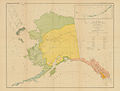
 Collier's 1921 Alaska.jpg 2.324 × 1.874; 922 KB
-
 Dall alaska1875.jpg 11.508 × 8.238; 4,29 MB
-
 Early Indian Languages Alaska.jpg 1.920 × 2.421; 920 KB
-
 Ecclesiastical Province of Anchorage map.png 554 × 470; 28 KB
-
 Ecclesiastical Province of Anchorage-Juneau map.png 535 × 393; 62 KB
-
 Estuarine and coastal drainage regions for Alaska USGS.jpg 575 × 445; 29 KB
-
 Marmota broweri range in ak.png 2.929 × 1.713; 46 KB
-
 Marmota caligata range in ak.png 1.501 × 832; 98 KB
-
 Petroff Tribes Map.jpg 650 × 492; 52 KB
-
 Proposed and existing hydropower and hydrokinetic projects in Alaska.png 2.300 × 1.777; 983 KB
-
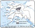 Rampart Dam drainage.jpg 500 × 398; 38 KB
-
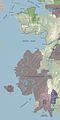
 Southeast Alaska.png 955 × 541; 59 KB
-
 Ursus arctos range in ak.png 2.929 × 1.713; 46 KB
-
 Ursus maritimus range in ak.png 2.929 × 1.713; 70 KB
-
 Western Alaska map 400x800.jpg 400 × 800; 43 KB
-
 Yukon watershed.png 500 × 500; 123 KB


