Category:Regions of Alaska
Sari la navigare
Sari la căutare
States of the United States: Alaska · Arizona · Arkansas · California · Carolina de Nord · Connecticut · Dakota de Sud · Florida · Idaho · Kentucky · Louisiana · Maryland · Massachusetts · Montana · Nevada · New Jersey · New Mexico · New York · Ohio · Oklahoma · Oregon · Pennsylvania · Tennessee · Texas · Utah · Virginia · Washington · Wisconsin · Wyoming
categorie a unui proiect Wikimedia | |||||
| Încarcă multimedia | |||||
| Este un/o | |||||
|---|---|---|---|---|---|
| Categoria combină subiectele | |||||
| Alaska | |||||
stat din Statele Unite ale Americii .jpg) someja da satełite in zuño     .svg)  | |||||
| Pronunție (fișier audio) | |||||
| Este un/o |
| ||||
| Parte din | |||||
| Locul actual | SUA | ||||
| Localizat pe malul | |||||
| Capitală | |||||
| Organ legislativ | |||||
| Executiv | |||||
| Cea mai înaltă autoritate judecătorească | |||||
| Limbă oficială |
| ||||
| Imn |
| ||||
| Șef de guvern |
| ||||
| Înființare |
| ||||
| Cel mai înalt punct | |||||
| Populație |
| ||||
| Suprafață |
| ||||
| Altitudine deasupra nivelului mării |
| ||||
| Înlocuiește |
| ||||
| Diferit(ă) de | |||||
| Maximum temperature record |
| ||||
| Minimum temperature record |
| ||||
| site oficial | |||||
 | |||||
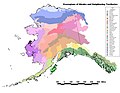
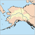
There is no general official classification of the regions of Alaska. There is a rough consensus for five or six regions, but no uniformity in their exact delineation. For classification on Commons, we use the scheme of the Alaska Regions identifier map, which divides along borough and census area boundaries. Other delineations are possible and maps illustrating these are welcome additions to this category. Please put illustrations of particular geographic features in the individual regions or their subcategories.

Magenta - Northern Alaska
Yellow - Interior Alaska
Blue - Southwest Alaska
Red - South-central Alaska
Green - Southeast Alaska
Subcategorii
Această categorie conține următoarele 8 subcategorii, dintr-un total de 8.
*
A
I
M
S
Fișiere media din categoria „Regions of Alaska”
Următoarele 33 fișiere se află în această categorie, dintr-un total de 33.
-
 Aian ak.pdf 7.200x5.400; 9,55 MB
-
 Akecoregions.jpg 1.270x979; 236 KB
-
 AKregionsNOAA.png 345x197; 6 KB
-
 Alaska climate regions USGS.gif 418x351; 17 KB
-
 Alaska judicial districts, early 1970s.jpg 1.926x1.471; 476 KB
-
 Alaska Köppen.svg 900x990; 862 KB
-
 Alaska land resources 2002.PNG 1.453x923; 1,06 MB
-
 Alaska level 4 hydrologic units.jpg 1.057x816; 238 KB
-
 Alaska permafrost zones.jpg 1.603x980; 306 KB
-
 Alaska rainfall map.jpg 1.610x993; 319 KB
-
 Alaska regions and watersheds NRCS.PNG 1.301x779; 756 KB
-
 Alaska Regions identifier map.png 800x453; 109 KB
-
 Alaska regions map.png 3.008x1.697; 1,46 MB
-
 Alaska vegetation and summer temperatures map.png 361x275; 18 KB
-
 ANCSA Regional Corporations Map.jpg 1.100x816; 83 KB
-
 ANCSA Regional Corporations on Alaska Map.svg 512x382; 695 KB
-
 BLM Alaska.PNG 792x510; 266 KB
-
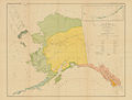
 Collier's 1921 Alaska.jpg 2.324x1.874; 922 KB
-
 Dall alaska1875.jpg 11.508x8.238; 4,29 MB
-
 Early Indian Languages Alaska.jpg 1.920x2.421; 920 KB
-
 Ecclesiastical Province of Anchorage map.png 554x470; 28 KB
-
 Ecclesiastical Province of Anchorage-Juneau map.png 535x393; 62 KB
-
 Estuarine and coastal drainage regions for Alaska USGS.jpg 575x445; 29 KB
-
 Marmota broweri range in ak.png 2.929x1.713; 46 KB
-
 Marmota caligata range in ak.png 1.501x832; 98 KB
-
 Petroff Tribes Map.jpg 650x492; 52 KB
-
 Proposed and existing hydropower and hydrokinetic projects in Alaska.png 2.300x1.777; 983 KB
-
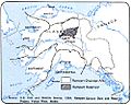 Rampart Dam drainage.jpg 500x398; 38 KB
-
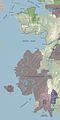
 Southeast Alaska.png 955x541; 59 KB
-
 Ursus arctos range in ak.png 2.929x1.713; 46 KB
-
 Ursus maritimus range in ak.png 2.929x1.713; 70 KB
-
 Western Alaska map 400x800.jpg 400x800; 43 KB
-
 Yukon watershed.png 500x500; 123 KB


