Category:River Exe
Vai alla navigazione
Vai alla ricerca
fiume dell'Inghilterra  Estuari de l'Exe amb Powderham Castle al darrere. | |||||
| Carica un file multimediale | |||||
| Istanza di | |||||
|---|---|---|---|---|---|
| Luogo | |||||
| Lunghezza |
| ||||
| Foce | |||||
| Bacino di drenaggio |
| ||||
| Affluente |
| ||||
 | |||||
Sottocategorie
Questa categoria contiene le 11 sottocategorie indicate di seguito, su un totale di 11.
B
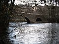
- Bickleigh Bridge, Mid Devon (14 F)
- Blackaller Weir (10 F)
E
F
- Exe Flood Relief Channel (110 F)
- River Exe in flood (3 F)
M
- Millers Crossing, Exeter (48 F)
R
- River Exe in Tiverton, Devon (186 F)
T
Pagine nella categoria "River Exe"
Questa categoria contiene un'unica pagina, indicata di seguito.
File nella categoria "River Exe"
Questa categoria contiene 200 file, indicati di seguito, su un totale di 430.
(pagina precedente) (pagina successiva)-
 2017 at Exeter TCD - viewed from across the river.JPG 1 366 × 1 024; 574 KB
-
 2019 at Exeter TMD (01) improving the flood defences.JPG 1 366 × 820; 363 KB
-

-
 A wintery River Exe, at Bickleigh - geograph.org.uk - 1625520.jpg 640 × 480; 63 KB
-
-
-
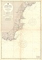 Admiralty Chart No 1613 Prawle Point to Straight Point, Published 1955.jpg 11 080 × 16 140; 13 MB
-
 Avocetandexe.jpg 4 160 × 3 120; 1,87 MB
-
 Bampton, on Halfpenny Bridge - geograph.org.uk - 216947.jpg 640 × 427; 218 KB
-

-
 Bank erosion on River Exe - geograph.org.uk - 272172.jpg 640 × 480; 113 KB
-
 Belle Isle - geograph.org.uk - 1072747.jpg 640 × 480; 117 KB
-
 Beneath the railway bridge - geograph.org.uk - 695283.jpg 640 × 450; 39 KB
-

-
-
 Bickleigh , The Fisherman's Cot - geograph.org.uk - 1200784.jpg 640 × 480; 111 KB
-
 Bickleigh , The River Exe - geograph.org.uk - 1341794.jpg 640 × 480; 60 KB
-
 Bickleigh , The River Exe - geograph.org.uk - 1581659.jpg 640 × 480; 131 KB
-
 Bickleigh , The River Exe - geograph.org.uk - 1581676.jpg 640 × 480; 135 KB
-
-
 Bickleigh, Devon geograph-4098803-by-Ben-Brooksbank.jpg 2 297 × 1 504; 5,07 MB
-
 Bickleigh, Devon geograph-4099664-by-Ben-Brooksbank.jpg 1 983 × 1 495; 5,36 MB
-
-
 Birds by The River Exe - geograph.org.uk - 1080566.jpg 640 × 439; 64 KB
-
 Birds on Ice Exeter - geograph.org.uk - 1111034.jpg 464 × 640; 58 KB
-
 Boats at Exeter Maritime Museum - geograph.org.uk - 1434858.jpg 640 × 440; 101 KB
-
 Bolham Weir - geograph.org.uk - 1296222.jpg 640 × 427; 379 KB
-
 Brampford Speke from across the Exe (geograph 1979831).jpg 640 × 506; 106 KB
-
 Brampford Speke Halt site 1973005 c2c2a3f8.jpg 1 496 × 1 030; 728 KB
-
 Bridge Cleaning - geograph.org.uk - 1049768.jpg 640 × 457; 85 KB
-
 Bridge over a pool by River Exe, Exeter (1).JPG 4 608 × 3 440; 4,21 MB
-
 Bridge over a pool by River Exe, Exeter (2).JPG 4 608 × 3 440; 4,45 MB
-
 Bridge over a pool by River Exe, Exeter (3).JPG 4 608 × 3 440; 4,14 MB
-
 Bridge over a pool by River Exe, Exeter (4).JPG 4 608 × 3 440; 4,1 MB
-
 Bridge over a pool by River Exe, Exeter (5).JPG 4 608 × 3 440; 4,22 MB
-
 Bridge over River Exe at Larcombe Foot. - geograph.org.uk - 228938.jpg 640 × 426; 182 KB
-
 Bridge over the Exe - geograph.org.uk - 1452069.jpg 640 × 480; 278 KB
-
 Bridge over the Exe - geograph.org.uk - 685251.jpg 640 × 480; 146 KB
-

-
 Bridge over the River Exe - geograph.org.uk - 1158413.jpg 640 × 453; 72 KB
-
-
 Bridges of Winsford - geograph.org.uk - 455270.jpg 640 × 480; 196 KB
-
 Bridgetown, Mill tail - geograph.org.uk - 685200.jpg 640 × 480; 138 KB
-
-
 Butt's Ferry crossing the River Exe - geograph.org.uk - 1286962.jpg 640 × 480; 71 KB
-
 Butterbur leaves at St James Weir - geograph.org.uk - 383684.jpg 640 × 480; 110 KB
-
 Chilly Bridge - geograph.org.uk - 678997.jpg 640 × 480; 119 KB
-
 Cockle Woman, Exmouth, Devon RMG G03128.tiff 4 488 × 6 496; 83,41 MB
-
 Collecting water from the river, Exeter. Wellcome L0015787.jpg 4 235 × 5 355; 5,88 MB
-
 Countess Weir, Exeter, England-LCCN2002696734.jpg 3 700 × 2 727; 3,09 MB
-
 Countess Weir, River Exe - geograph.org.uk - 1109011.jpg 640 × 430; 116 KB
-
 Cove Bridge - geograph.org.uk - 85821.jpg 640 × 480; 62 KB
-
 Cowley Steps - geograph.org.uk - 1741621.jpg 640 × 441; 103 KB
-
 Crossing the Exe near West Nethercote - geograph.org.uk - 271324.jpg 640 × 426; 182 KB
-
 Cyclist and pedestrian by River Exe - geograph.org.uk - 320752.jpg 640 × 480; 80 KB
-
 Dawlish Warren - CrossCountry 221129 down train.JPG 1 366 × 910; 565 KB
-
 Dawlish Warren - FGW 57605.JPG 1 366 × 820; 502 KB
-
 Down the Exe from Mallison Bridge - geograph.org.uk - 1136498.jpg 640 × 480; 67 KB
-
 Dragon Boats racing on the River Exe - geograph.org.uk - 1523721.jpg 640 × 480; 238 KB
-
 Dulverton, the Exe above Helebridge - geograph.org.uk - 316354.jpg 640 × 427; 171 KB
-
 DuvaleByJohnSwete.jpg 4 142 × 2 775; 12,44 MB
-
-
 East Barton from the Exe Valley Way - geograph.org.uk - 1546961.jpg 640 × 482; 110 KB
-
 East end of Exeter Quay - geograph.org.uk - 1069202.jpg 477 × 640; 87 KB
-
 Entrance to Exeter Canal Basin (1).JPG 4 608 × 3 440; 4,27 MB
-
 Entrance to Exeter Canal Basin (2).JPG 4 608 × 3 440; 3,96 MB
-
 Exbridge - Devon & Somerset border - River Exe (23222130062).jpg 2 592 × 1 944; 2,13 MB
-
 Exbridge Exeter England.jpg 1 076 × 837; 111 KB
-
 Exbridge, Exeter, England-LCCN2002696735.jpg 3 702 × 2 748; 2,39 MB
-
 Exbridge, Exeter, England-LCCN2002696735.tif 3 702 × 2 748; 29,11 MB
-
 Exe above St James Weir - geograph.org.uk - 1369221.jpg 640 × 480; 81 KB
-
 Exe and leat, Bickleigh - geograph.org.uk - 1546949.jpg 640 × 480; 131 KB
-
 Exe below Exe Bridge South - geograph.org.uk - 1136208.jpg 474 × 640; 69 KB
-
 Exe Bridge from Bridge St Exeter cropped.jpg 768 × 1 023; 397 KB
-
 Exe Bridge from Bridge St Exeter.jpg 1 024 × 636; 280 KB
-
 Exe Bridge North - geograph.org.uk - 1136079.jpg 640 × 480; 67 KB
-
 Exe Bridge South - geograph.org.uk - 1136141.jpg 640 × 480; 77 KB
-
 Exe Bridges - geograph.org.uk - 1070793.jpg 640 × 491; 85 KB
-
 Exe Cleave - geograph.org.uk - 527161.jpg 2 272 × 1 704; 2,35 MB
-
 Exe flood plain and river at Brampford Speke (geograph 1979987).jpg 640 × 495; 74 KB
-
 Exe Flood Relief Channel - geograph.org.uk - 167446.jpg 640 × 480; 85 KB
-
 Exe Ford at West End of Long Barrow - geograph.org.uk - 527437.jpg 640 × 480; 155 KB
-
 Exe Head - geograph.org.uk - 445725.jpg 640 × 426; 119 KB
-
 Exe Head Bridge - geograph.org.uk - 501706.jpg 640 × 426; 132 KB
-
 Exe Head Bridge East Parapet - geograph.org.uk - 501741.jpg 640 × 426; 155 KB
-
 Exe valley near Great Ashcombe - geograph.org.uk - 974439.jpg 640 × 427; 80 KB
-
 Exe@Exmouth.jpg 3 072 × 2 304; 1,27 MB
-
 Exebridge- View downstream (geograph 1807918).jpg 800 × 535; 541 KB
-
-
 Exeter , River Exe and Pavement - geograph.org.uk - 1345937.jpg 640 × 480; 43 KB
-
 Exeter docks-1 com.jpg 2 416 × 938; 1,74 MB
-
 Exeter Flood Relief Bridge - fGWR 143619+143603 Paignton service.JPG 1 366 × 820; 453 KB
-
 Exeter Flood Relief Bridge - GWR 150233 Plymouth service.JPG 1 366 × 820; 405 KB
-
 Exeter Flood Relief Bridge 221120.jpg 1 024 × 768; 212 KB
-
 Exeter Quay, Marker Buoy landmark - geograph.org.uk - 1206401.jpg 640 × 469; 95 KB
-
 Exeter Quays - geograph.org.uk - 1504601.jpg 640 × 480; 59 KB
-

-
 Exford, Pennycombe Water - geograph.org.uk - 89947.jpg 640 × 427; 175 KB
-
 Exmouth (48044270988).jpg 4 409 × 1 717; 5,65 MB
-
 Exmouth SSSI sign.jpg 768 × 1 024; 489 KB
-

-
 Exton, the Exe above Kent's Weir - geograph.org.uk - 316350.jpg 640 × 427; 265 KB
-
 Exton, the Exe near Higher Hone - geograph.org.uk - 316348.jpg 640 × 427; 241 KB
-
 Exwick Flood Channel - geograph.org.uk - 582066.jpg 640 × 420; 81 KB
-
 Fisherman's Cot at Bickleigh - geograph.org.uk - 678950.jpg 640 × 480; 100 KB
-
 Fisherman's Cot, Bickleigh - geograph.org.uk - 31086.jpg 600 × 399; 137 KB
-
 Flats beside River Exe, reduced flow - geograph.org.uk - 690909.jpg 570 × 427; 182 KB
-
 Flats beside River Exe, reduced flow - geograph.org.uk - 690918.jpg 570 × 427; 167 KB
-
 Flood debris, Exeter - geograph.org.uk - 1164767.jpg 640 × 480; 98 KB
-
 Flood relief channel joining River Exe - geograph.org.uk - 292249.jpg 640 × 480; 145 KB
-
 Flooded gardens, Bonhay Road, Exeter - geograph.org.uk - 287205.jpg 640 × 480; 148 KB
-
 Flooded path by the Exe, Exeter Quay - geograph.org.uk - 286880.jpg 480 × 640; 92 KB
-

-
 Flotsam, River Exe - geograph.org.uk - 289547.jpg 640 × 480; 94 KB
-

-
 Footbridge across part of the River Exe - geograph.org.uk - 1109020.jpg 640 × 430; 115 KB
-

-
 Footbridge over the River Exe - geograph.org.uk - 679022.jpg 640 × 480; 121 KB
-
 Ford and footbridge at Westermill Farm.jpg 3 841 × 2 513; 6,17 MB
-
 Ford in river Exe - geograph.org.uk - 526993.jpg 640 × 480; 123 KB
-
 Ford over the Exe - geograph.org.uk - 685239.jpg 640 × 480; 160 KB
-
 Ford through the Exe - geograph.org.uk - 395160.jpg 640 × 480; 188 KB
-
 From the river Exeter England.jpg 1 070 × 837; 129 KB
-
 From the river, Exeter, England-LCCN2002696736.jpg 3 680 × 2 748; 2,59 MB
-
 From the river, Exeter, England-LCCN2002696736.tif 3 680 × 2 748; 28,94 MB
-
 Gasometers across the Exe - geograph.org.uk - 320721.jpg 640 × 472; 64 KB
-
 Great Buscombe - geograph.org.uk - 731258.jpg 640 × 426; 81 KB
-
 Great Ferny Ball Ford - geograph.org.uk - 411660.jpg 640 × 480; 134 KB
-
 Grounds of Larkbeare House Exeter - geograph.org.uk - 691013.jpg 570 × 427; 220 KB
-
 Grounds of Larkbeare House, Exeter - geograph.org.uk - 691011.jpg 570 × 427; 207 KB
-
 Gulls, on a frozen River Exe - geograph.org.uk - 1655633.jpg 640 × 480; 69 KB
-

-
 Halfpenny Bridge - geograph.org.uk - 85827.jpg 640 × 480; 44 KB
-
 Harbour buoy, Exeter docks - geograph.org.uk - 1655598.jpg 640 × 480; 92 KB
-
 Haven Banks from Mallison Bridge - geograph.org.uk - 1089228.jpg 515 × 640; 83 KB
-
 Haven Banks Malthouse - geograph.org.uk - 1136258.jpg 640 × 473; 81 KB
-
 Head Weir, River Exe - geograph.org.uk - 287220.jpg 640 × 480; 97 KB
-
 Head Weir, River Exe - geograph.org.uk - 287223.jpg 640 × 480; 85 KB
-
 Head Weir, River Exe - geograph.org.uk - 372386.jpg 480 × 640; 114 KB
-
 Head Weir, River Exe - geograph.org.uk - 372390.jpg 480 × 640; 114 KB
-
 Head Weir, River Exe - geograph.org.uk - 372392.jpg 640 × 480; 125 KB
-
 Hele Bridge - geograph.org.uk - 685246.jpg 640 × 480; 114 KB
-
 High water at Belle Isle Park - geograph.org.uk - 358200.jpg 640 × 477; 107 KB
-
 Higher Weir River Exe - geograph.org.uk - 1069354.jpg 640 × 463; 119 KB
-
 Home to Roost - geograph.org.uk - 1069314.jpg 640 × 461; 108 KB
-
 Housing by the Exe - geograph.org.uk - 1089051.jpg 640 × 480; 108 KB
-

-

-
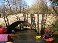 Kayakers on the Exe - geograph.org.uk - 685199.jpg 640 × 480; 139 KB
-

-
 Lower Nutwell Farmhouse.jpg 5 568 × 3 712; 12,53 MB
-
 Lympstone - GWR 150246+150266 beside the river.JPG 2 732 × 1 640; 2,39 MB
-
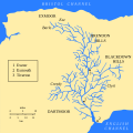 Map of River Exe en.svg 600 × 600; 71 KB
-
 Map of the River Exe - Exe highlighted.svg 600 × 600; 82 KB
-
 Marker buoy on land^ - geograph.org.uk - 1110778.jpg 640 × 430; 50 KB
-
 Meander in the Exe - geograph.org.uk - 165498.jpg 480 × 640; 90 KB
-
 Milton's Bridge - geograph.org.uk - 685237.jpg 640 × 480; 123 KB
-

-

-
 Modern roadbridge over the River Exe - geograph.org.uk - 1274754.jpg 640 × 480; 72 KB
-
 Morning sun over the Exe - geograph.org.uk - 1069917.jpg 640 × 480; 85 KB
-
 New development, Exeter Quay - geograph.org.uk - 1110767.jpg 640 × 430; 60 KB
-
 Old Abbey Court, Exeter - geograph.org.uk - 1656369.jpg 640 × 480; 79 KB
-

-
 On The Exe - geograph.org.uk - 1069299.jpg 640 × 462; 47 KB
-
 On the Waterfront Pub, Exeter, Exeter Ship Canal - geograph.org.uk - 1748067.jpg 2 048 × 1 536; 609 KB
-
 Ordnance Survey Drawings - Exmouth (OSD 39).jpg 5 791 × 3 137; 3,96 MB
-
 Ordnance Survey One-Inch Sheet 138 Dartmoor & Exeter, Published 1919.jpg 12 235 × 8 499; 12,78 MB
-
 Ordnance Survey One-Inch Sheet 164 Minehead, Published 1946.jpg 8 180 × 9 562; 11,42 MB
-
 Ordnance Survey One-Inch Sheet 164 Minehead, Published 1966.jpg 8 357 × 9 979; 11,67 MB
-
 Ordnance Survey One-Inch Sheet 164 Minehead, Published 1972.jpg 11 045 × 13 186; 46,57 MB
-
 Ordnance Survey One-Inch Sheet 176 Exeter, Published 1946.jpg 8 211 × 9 535; 11,2 MB
-
 Ordnance Survey One-Inch Sheet 176 Exeter, Published 1967.jpg 8 307 × 9 960; 11,6 MB
-
 Ordnance Survey One-Inch Sheet 176 Exeter, Published 1972.jpg 10 995 × 13 150; 48,65 MB
-
 Part of Exeter Quays - geograph.org.uk - 1110738.jpg 640 × 430; 61 KB
-
 Path by the Exe - geograph.org.uk - 1150513.jpg 480 × 640; 75 KB
-
 Pitt Farm - geograph.org.uk - 1126669.jpg 640 × 480; 58 KB
-
 Pontoon, Exeter Quay - geograph.org.uk - 1137350.jpg 480 × 640; 78 KB
-
 Port Royal - geograph.org.uk - 1110774.jpg 640 × 430; 81 KB
-
 Port Royal Inn, River Exe in reduced flow - geograph.org.uk - 691016.jpg 570 × 427; 168 KB
-

-

-

-
 Quayside with dredging work - geograph.org.uk - 690886.jpg 570 × 427; 167 KB
-
 Railway bridge and spire, Exeter - geograph.org.uk - 1164648.jpg 435 × 640; 34 KB
-

-
 Railway bridge, remains of - geograph.org.uk - 685734.jpg 640 × 480; 100 KB
-
 Ready for Take Off - geograph.org.uk - 1058760.jpg 640 × 445; 59 KB
-

-

-
 Renslade House, Exeter - geograph.org.uk - 1070782.jpg 404 × 640; 64 KB
-
 Renslade House, Exeter - geograph.org.uk - 289624.jpg 480 × 640; 71 KB
-
 River and railways at Cowley Bridge.jpg 1 024 × 768; 344 KB
-

-
 River Exe (2) - geograph.org.uk - 1111190.jpg 640 × 430; 62 KB
-
 River Exe (29549319488).jpg 4 505 × 2 694; 3,95 MB
-
 River Exe (42132230354).jpg 4 655 × 2 877; 3,29 MB
-
 River Exe - geograph.org.uk - 1111183.jpg 640 × 430; 84 KB
-
 River Exe - geograph.org.uk - 555493.jpg 640 × 480; 86 KB
-
 River Exe - geograph.org.uk - 634364.jpg 640 × 480; 74 KB

_improving_the_flood_defences.JPG)


_-_geograph.org.uk_-_1110689.jpg)


.jpg)


.JPG)
.JPG)
.JPG)
.JPG)
.JPG)


.JPG)
.JPG)
.jpg)


.jpg)


.jpg)


.jpg)


_-_geograph.org.uk_-_690906.jpg)


_-_geograph.org.uk_-_1111190.jpg)
.jpg)
.jpg)


.jpg)