Category:Rothienorman
Aller à la navigation
Aller à la recherche
village  | |||||
| Téléverser des médias | |||||
| Nature de l’élément | |||||
|---|---|---|---|---|---|
| Lieu |
| ||||
| Population |
| ||||
 | |||||
English: Rothienorman is a village in north east Scotland.
Sous-catégories
Cette catégorie comprend seulement la sous-catégorie ci-dessous.
R
- Rothienorman railway station (1 F)
Média dans la catégorie « Rothienorman »
Cette catégorie comprend 43 fichiers, dont les 43 ci-dessous.
-
 Crest of Hill above Folla Rule - geograph.org.uk - 28572.jpg 640 × 480 ; 74 kio
-
 Disused Railway line Aberdeenshire - geograph.org.uk - 768814.jpg 640 × 427 ; 88 kio
-
 Road to Rothienorman - geograph.org.uk - 774582.jpg 640 × 480 ; 73 kio
-
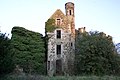 Rothie House Nr Rothienorman Aberdeenshire - geograph.org.uk - 765409.jpg 640 × 427 ; 72 kio
-
 Rothie Inn, Rothienorman.jpg 500 × 375 ; 97 kio
-
 Rothie Rovers F.C., Forgue Road, Rothienorman.jpg 3 521 × 2 563 ; 1,78 Mio
-
 Sunnyside of Folla - geograph.org.uk - 28650.jpg 640 × 480 ; 96 kio
-
 The Old Mill near Blackford - geograph.org.uk - 1126522.jpg 640 × 480 ; 67 kio
-
 View north west to Brownhill - geograph.org.uk - 774309.jpg 640 × 480 ; 79 kio
-
 Westertown of Folla - geograph.org.uk - 774372.jpg 640 × 480 ; 84 kio
-
 Xmas trees on Hill of Rothmaise - geograph.org.uk - 86383.jpg 640 × 427 ; 108 kio
-
 B9001 - geograph.org.uk - 666145.jpg 640 × 426 ; 56 kio
-
 B9001 - geograph.org.uk - 666146.jpg 640 × 426 ; 64 kio
-
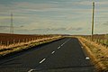
 B9001 looking toward Rothienorman - geograph.org.uk - 666150.jpg 640 × 426 ; 86 kio
-
 B9001 near Wells of Rothie - geograph.org.uk - 666143.jpg 640 × 426 ; 62 kio
-
 B9001 north of Rothienorman - geograph.org.uk - 666149.jpg 640 × 426 ; 55 kio
-
 Black Burn and The Mill - geograph.org.uk - 666158.jpg 640 × 426 ; 112 kio
-
 Country road near Mill of Burns farm. - geograph.org.uk - 666209.jpg 640 × 426 ; 61 kio
-
 Country road to Rothie Vale - geograph.org.uk - 666213.jpg 640 × 426 ; 115 kio
-
 Country road to Rothie Vale - geograph.org.uk - 666214.jpg 640 × 426 ; 99 kio
-
 Cranna farm - geograph.org.uk - 666211.jpg 640 × 426 ; 40 kio
-
 Drum Garage and Filling Station - geograph.org.uk - 591211.jpg 640 × 480 ; 110 kio
-
 Farm entrance to Hill of Wells - geograph.org.uk - 666147.jpg 640 × 426 ; 88 kio
-
 Farm road to Blackford Home Farm - geograph.org.uk - 666157.jpg 640 × 426 ; 118 kio
-
 Farm road to Rogerseat - geograph.org.uk - 666154.jpg 640 × 426 ; 67 kio
-
 Farm track to Crannabog - geograph.org.uk - 666201.jpg 640 × 426 ; 59 kio
-
 Folla - geograph.org.uk - 666183.jpg 640 × 426 ; 75 kio
-
 Hill of Wells - geograph.org.uk - 666151.jpg 640 × 426 ; 42 kio
-
 In the Trees at Brown Hill - geograph.org.uk - 774313.jpg 640 × 480 ; 119 kio
-
 Ladenhar - geograph.org.uk - 666202.jpg 640 × 426 ; 82 kio
-
 Mill of Burns Farm - geograph.org.uk - 666200.jpg 640 × 426 ; 55 kio
-
 Mill of Burns Farm - geograph.org.uk - 666203.jpg 640 × 426 ; 85 kio
-
 Minor road past Cowhill - geograph.org.uk - 666198.jpg 640 × 426 ; 62 kio
-
 Minor road to Folla Rule - geograph.org.uk - 666185.jpg 640 × 426 ; 91 kio
-
 Minor road to Waulkmill - geograph.org.uk - 666210.jpg 640 × 426 ; 62 kio
-
 Road and bridge over the Black Burn - geograph.org.uk - 666159.jpg 640 × 426 ; 96 kio
-
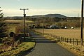
 Road junction with the B9001 - geograph.org.uk - 666182.jpg 640 × 426 ; 68 kio
-
 Road past Waulkmill farm - geograph.org.uk - 666212.jpg 640 × 426 ; 75 kio
-
 Small burn near Folla Rule - geograph.org.uk - 666186.jpg 640 × 426 ; 113 kio
-
 Springleys - geograph.org.uk - 666199.jpg 640 × 426 ; 80 kio
-
 Track to Gallows Hill - geograph.org.uk - 666148.jpg 640 × 426 ; 105 kio
-
-
 View of Bennachie on road to Folla Rule - geograph.org.uk - 174316.jpg 640 × 480 ; 62 kio


