Category:Rowledge
Aller à la navigation
Aller à la recherche
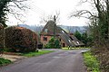
English: Rowledge is a village in Surrey, England but lies very close to the border with Hampshire. It lies south of the A31 running between Farnham and Alton. Neighbouring villages include Wrecclesham, Spreakley and Frensham. To the south west of the village is the Alice Holt Forest; to the west is Birdworld.
village britannique  | |||||
| Téléverser des médias | |||||
| Nature de l’élément | |||||
|---|---|---|---|---|---|
| Lieu | |||||
 | |||||
Sous-catégories
Cette catégorie comprend 5 sous-catégories, dont les 5 ci-dessous.
C
- Cherry Tree pub, Rowledge (4 F)
H
J
- St James's Church, Rowledge (26 F)
R
- Rowledge Methodist Church (10 F)
- Rowledge War Memorial (1 F)
Média dans la catégorie « Rowledge »
Cette catégorie comprend 7 fichiers, dont les 7 ci-dessous.
-
 Hampshire, Rowledge - geograph.org.uk - 2742263.jpg 4 288 × 3 216 ; 3,26 Mio
-
 Micky Stewart 2019.jpg 1 669 × 1 670 ; 850 kio
-
 Rowledge PO, Farnham GU9 Aug 1992 - Flickr - sludgegulper.jpg 1 764 × 1 176 ; 184 kio
-
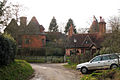
 The Oast House - geograph.org.uk - 383253.jpg 640 × 428 ; 170 kio
-
-
 Fields South of Rowledge - geograph.org.uk - 272573.jpg 640 × 480 ; 148 kio
-
 Sandrock Hill Road Boundstone - geograph.org.uk - 272581.jpg 640 × 480 ; 120 kio


