Category:San Nicolas Island
Zur Navigation springen
Zur Suche springen
- San Nicolas Island — the most remote of California Channel Islands, and part of Ventura County, Southern California.
- Currently controlled by the United States Navy for use as a weapons testing and training facility, operated by the Pacific Missile Test Center Point Mugu.
- Location of the Naval Outlying Field San Nicolas Island.
Insel der Kanalinseln von Kalifornien, USA  | |||||
| Medium hochladen | |||||
| Ist ein(e) | |||||
|---|---|---|---|---|---|
| Ist Teil von | |||||
| Ort | Ventura County, Kalifornien, Pacific States Region | ||||
| Liegt am oder im Gewässer | |||||
| Betreiber | |||||
| Breite |
| ||||
| Länge |
| ||||
| Einwohnerzahl |
| ||||
| Fläche |
| ||||
| Höhe über dem Meeresspiegel |
| ||||
| offizielle Website | |||||
 | |||||
Unterkategorien
Es werden 2 von insgesamt 2 Unterkategorien in dieser Kategorie angezeigt:
In Klammern die Anzahl der enthaltenen Kategorien (K), Seiten (S), Dateien (D)
N
Medien in der Kategorie „San Nicolas Island“
Folgende 22 Dateien sind in dieser Kategorie, von 22 insgesamt.
-

-
 Californiakillingfields.jpg 648 × 492; 153 KB
-
DOD Conducts Ground-launched Cruise Missile Test (190818-O-PZ834-724).webm 41 s, 2.560 × 1.440; 15,82 MB
-
 Island fox, San Nicolas Island (26857935685).jpg 1.515 × 961; 732 KB
-
 ISS066-E-1941 - View of Earth.jpg 5.568 × 3.712; 1,74 MB
-
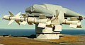
 MQM-8 Vandal 1.jpg 300 × 285; 15 KB
-
 MQM-8 Vandal 2.jpg 400 × 214; 22 KB
-
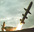
 MQM-8G Vandal missile launch 1999.jpg 2.657 × 1.995; 798 KB
-
 P Schumacher 9.png 1.829 × 3.239; 2,26 MB
-
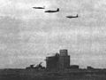 Regulus missile with chase planes over San Nicolas Island c1957.jpg 1.053 × 788; 706 KB
-
 San Nicholas Island California military facilities.png 734 × 385; 353 KB
-
 San Nicolas Island (27048963529).jpg 4.032 × 3.024; 1,77 MB
-
 San Nicolas Island Aerial Navy.jpg 400 × 234; 42 KB
-
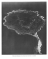
 San Nicolas Island aerial view.jpg 750 × 600; 338 KB
-
 San Nicolas Island, from 1896 book Elementary Physical Geography.jpg 1.087 × 468; 145 KB
-
 San Nicolas Island.png 1.264 × 1.552; 1,25 MB
-
 Translocation-loutre-de-mer.png 600 × 438; 48 KB
-
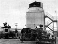 Turret cameras at Pacific Missile Range in 1957.jpg 863 × 665; 383 KB
-

-
 US Ground-launched cruise missile at San Nicolas Island (2019-08-18).jpg 2.560 × 1.440; 2,3 MB
-
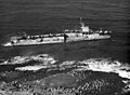 USS Makassar Strait (CVE-91) aground on San Nicolas Island c1963.jpeg 1.872 × 1.368; 1,38 MB
-
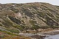 West End San Nicolas.jpg 2.000 × 1.333; 3,07 MB


.jpg)


.jpg)


.jpg)
_aground_on_San_Nicolas_Island_c1963.jpeg)
