Category:Scarp, Scotland
Aller à la navigation
Aller à la recherche
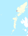
île des Hébrides extérieures, Écosse  | |||||
| Téléverser des médias | |||||
| Nature de l’élément | |||||
|---|---|---|---|---|---|
| Partie de | |||||
| Lieu | Hébrides extérieures, Écosse | ||||
| Baigné par | |||||
 | |||||
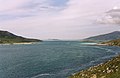
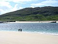
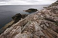
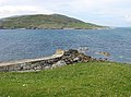
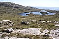
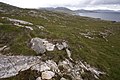
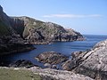
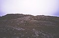
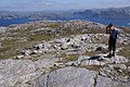
Scarp is an uninhabited island in the Outer Hebrides of Scotland, west of Hushinish on Harris. Once inhabited, the island was the scene of unsuccessful experiments with rocket mail, since commemorated in two films.
Média dans la catégorie « Scarp, Scotland »
Cette catégorie comprend 38 fichiers, dont les 38 ci-dessous.
-
 Alabost Shieling - geograph.org.uk - 476571.jpg 640 × 428 ; 122 kio
-
 Caolas an Scarp - geograph.org.uk - 1258473.jpg 640 × 480 ; 67 kio
-
 Caolas an Scarp - geograph.org.uk - 1258840.jpg 640 × 480 ; 59 kio
-
 Caolas an Scarp - geograph.org.uk - 788580.jpg 1 000 × 654 ; 231 kio
-
 Caolas an Scarp - geograph.org.uk - 855302.jpg 640 × 418 ; 64 kio
-
 Caolas an Scarp - geograph.org.uk - 927413.jpg 640 × 480 ; 90 kio
-
 Caolas an Scarp from beach at Grescleit - geograph.org.uk - 1258812.jpg 640 × 480 ; 59 kio
-
 Cemetery, Scarp - geograph.org.uk - 1407915.jpg 640 × 480 ; 152 kio
-
 Coastline West Scarp - geograph.org.uk - 883740.jpg 640 × 428 ; 85 kio
-
 Deserted village of Scarp - geograph.org.uk - 1297163.jpg 640 × 480 ; 59 kio
-
 Geodha Islaca, Scarp - geograph.org.uk - 883764.jpg 640 × 428 ; 98 kio
-
 Hushinish slipway view of Scarp in distance.jpg 1 280 × 960 ; 174 kio
-
 Jetty at Huisinis - geograph.org.uk - 502129.jpg 640 × 477 ; 133 kio
-
 Manais Point, Scarp - geograph.org.uk - 883758.jpg 640 × 428 ; 88 kio
-
 Mol Mor Scarp - geograph.org.uk - 872517.jpg 640 × 480 ; 68 kio
-
 North shore of Scarp - geograph.org.uk - 1963305.jpg 2 048 × 1 536 ; 1,03 Mio
-
 On Beinn Fo Thuath - geograph.org.uk - 19122.jpg 455 × 296 ; 23 kio
-
 Rubha na Creadha, Scarp - geograph.org.uk - 4597627.jpg 640 × 378 ; 69 kio
-
 Rubha Ruadh - geograph.org.uk - 4597587.jpg 640 × 424 ; 58 kio
-
 Scarp - Loch Uidemul - geograph.org.uk - 476570.jpg 640 × 428 ; 154 kio
-
 Scarp beach - geograph.org.uk - 193318.jpg 640 × 480 ; 116 kio
-
 Scarp OH.svg 1 083 × 1 424 ; 2,36 Mio
-
 Scarp Phone Kiosk - geograph.org.uk - 1407908.jpg 480 × 640 ; 218 kio
-
 Scarp West Coast - geograph.org.uk - 883726.jpg 640 × 428 ; 91 kio
-
 Sea Cave, North Coast of Scarp - geograph.org.uk - 190106.jpg 640 × 480 ; 90 kio
-
 Sea cliffs, Caolas an Scarp - geograph.org.uk - 788575.jpg 640 × 466 ; 122 kio
-
 Skerries off Scarp - geograph.org.uk - 4597588.jpg 640 × 438 ; 57 kio
-
 Slipway at Scarp - geograph.org.uk - 1297167.jpg 640 × 480 ; 65 kio
-
 South Scarp - geograph.org.uk - 883723.jpg 640 × 428 ; 85 kio
-
 View to Scarp from the Island of Liongam - geograph.org.uk - 533956.jpg 640 × 360 ; 69 kio
-
 Village, Scarp - geograph.org.uk - 19123.jpg 455 × 299 ; 21 kio
-
 Western extremity of Oisteim - geograph.org.uk - 4597589.jpg 640 × 518 ; 90 kio
-
 Western extremity of Scarp - geograph.org.uk - 4597612.jpg 640 × 446 ; 68 kio
-
 Leaving the beach. - geograph.org.uk - 19119.jpg 640 × 414 ; 76 kio
-
 North Coast of Scarp - geograph.org.uk - 190108.jpg 640 × 480 ; 130 kio
-
 Sron Romul - geograph.org.uk - 19121.jpg 456 × 293 ; 20 kio
-
 Sron Romul Summit (308m) - geograph.org.uk - 476569.jpg 640 × 428 ; 143 kio
-
 Sron Romul to Loch Reasort - geograph.org.uk - 476568.jpg 640 × 428 ; 154 kio


_-_geograph.org.uk_-_476569.jpg)
