Category:Schilthorn
ナビゲーションに移動
検索に移動
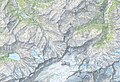
| 被写体の位置 | | 全ての座標を示した地図 - オープンストリートマップ |
|---|
mountain   | |||||
| メディアをアップロード | |||||
| 分類 | |||||
|---|---|---|---|---|---|
| 場所 | ベルン州, スイス | ||||
| 山脈 |
| ||||
| プロミネンス |
| ||||
| アイソレーション |
| ||||
| 標高 |
| ||||
| 主峰 | |||||
 | |||||
下位カテゴリ
このカテゴリに属する 5 個のサブカテゴリのうち、 5 個を表示しています。
カテゴリ「Schilthorn」にあるメディア
このカテゴリに属する 50 個のファイルのうち、 50 個を表示しています。
-
 1248 Mürren.jpg 14,000 × 9,600;134.85メガバイト
-
 20071998. Shilthorn.jpg 1,056 × 1,415;252キロバイト
-
 5157 - Eigergletscher Station.JPG 3,648 × 2,736;2.49メガバイト
-
 A schilthorn on summer 2020 (2).jpg 1,210 × 1,613;480キロバイト
-
 Alpine flowers and slope with sharp profile at Schilthorn in 2012 August.jpg 2,850 × 1,897;3.31メガバイト
-
 Alpjuhorn, Schilthorn and Grisighorn as seen from Sparrhorn.jpg 2,294 × 1,805;845キロバイト
-
 Amongst the clouds.jpg 3,276 × 4,096;2.78メガバイト
-
 Ascenting Schilthorn from the west ridge, 2012 August.jpg 5,860 × 2,365;7.07メガバイト
-
 Chilchflue seen from Schilthorn.jpg 4,032 × 3,024;965キロバイト
-
 Cows in Schilttal at Schilthorn in 2012 August - 2.jpg 3,000 × 2,000;5.69メガバイト
-
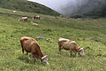 Cows in Schilttal at Schilthorn in 2012 August.jpg 3,000 × 2,000;5.76メガバイト
-

-

-
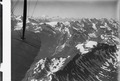
 ETH-BIB-Schilthorn, Gspaltenhorn v. N. O. aus 3800 m-Inlandflüge-LBS MH01-000284.tif 6,389 × 4,732;86.67メガバイト
-
-
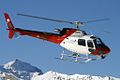 Eurocopter AS-350B-3 Ecureuil, Heli-Linth AN1174998.jpg 1,024 × 683;201キロバイト
-
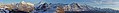 Faulhorn-S-Pano.jpg 17,893 × 1,958;4.36メガバイト
-
 Faulhorn-SW-Pano.jpg 11,261 × 1,856;7.16メガバイト
-
 Februar 1962 Schilthorn s.jpg 1,704 × 2,272;792キロバイト
-
 Februar 1962 Schilthorn.jpg 2,272 × 1,704;796キロバイト
-
 Grauseeroli.JPG 1,944 × 2,592;1.51メガバイト
-
 Güwtürli-SW-Pano.jpg 12,416 × 1,856;7メガバイト
-
 Helikopterflug in den Berner Alpen von Lauterbrunnen ausgehen (2014) -34.JPG 5,184 × 3,456;5.31メガバイト
-
 Helikopterflug in den Berner Alpen von Lauterbrunnen ausgehen (2014) -38.JPG 5,184 × 3,456;6.41メガバイト
-
 Im Fokus.jpg 6,016 × 4,000;10.55メガバイト
-

-

-
 JAMES BOND 007, SCHILTHORN, PIZ GLORIA, FEBRUARY 2014. - panoramio (2).jpg 2,592 × 1,944;2.13メガバイト
-
 Kabine Schilthorn TUD5778 webalbum 1 print.jpg 9,000 × 6,009;5.33メガバイト
-
 Kidsslope h2a0066 webalbum print.jpg 9,000 × 6,000;4.66メガバイト
-
 Rock columns at Schilthorn in 2012 August.jpg 3,000 × 2,000;5.22メガバイト
-
 Sanne at the top of the Schilthorn (10955604593).jpg 2,067 × 1,451;2.37メガバイト
-
 Schilthorn Drohne 1787 2 1 print.jpg 9,000 × 5,999;4.67メガバイト
-
 Schilthorn from Birg summer 20.jpg 908 × 1,210;263キロバイト
-
 Schilthorn Gipfelstation.jpg 1,386 × 1,014;848キロバイト
-
 Schilthorn wegweiser.jpg 1,760 × 2,640;929キロバイト
-
 Schilthorn, Mürren with paraglider.jpg 2,448 × 3,264;2.82メガバイト
-
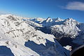
 Schilthorn-S-Pano.jpg 4,004 × 1,001;802キロバイト
-
 Schilthorn-scan-mamo-024 webalbum gall.jpg 2,000 × 1,500;378キロバイト
-
 Schilthorn.png 633 × 545;480キロバイト
-
 Schilthornbahn in Mürren.jpg 1,772 × 1,188;374キロバイト
-
 Schlussaufstieg zum Schilthorn.jpg 3,000 × 4,000;2.99メガバイト
-
 Sign on Schilthorn 01.jpg 1,657 × 1,108;222キロバイト
-
 Sign on Schilthorn 02.jpg 422 × 415;30キロバイト
-
 Signpost of Roter Herd in 2012 August.jpg 3,600 × 2,400;6.52メガバイト
-
 Summit of Schilthorn reveals itself above the clouds in 2012 August - 2.jpg 2,000 × 3,000;4.36メガバイト
-
 Summit of Schilthorn reveals itself above the clouds in 2012 August.jpg 3,000 × 2,000;4.66メガバイト
-
 The Alps.jpg 4,032 × 3,024;3.41メガバイト
-
 View from Schilthorn - panoramio.jpg 1,600 × 1,067;655キロバイト
-
 With the clouds.jpg 3,024 × 3,780;2.81メガバイト


.jpg)


_-34.JPG)
_-38.JPG)

.jpg)
_(cropped).jpg)
.jpg)


.jpg)


