Category:Severn Estuary
Aller à la navigation
Aller à la recherche
English: The estuary of the River Severn. Noted for the world's second-highest tidal range and also the Severn Bore.
estuary and Site of Special Scientific Interest in Wales  | |||||
| Téléverser des médias | |||||
| Nature de l’élément | |||||
|---|---|---|---|---|---|
| Partie de | |||||
| Lieu |
| ||||
| Statut patrimonial | |||||
| Superficie |
| ||||
| Affluent | |||||
| À ne pas confondre avec | |||||
 | |||||
Sous-catégories
Cette catégorie comprend 14 sous-catégories, dont les 14 ci-dessous.
A
C
- Caldicot Levels (31 F)
F
G
- Garden Cliff (10 F)
H
- High tide in the Severn Estuary (11 F)
L
- Low tide in the Severn Estuary (43 F)
P
- Severn powerline crossing (21 F)
S
- St Pierre Pill (8 F)
Média dans la catégorie « Severn Estuary »
Cette catégorie comprend 113 fichiers, dont les 113 ci-dessous.
-
 14 Port of Bristol docks in Avonmouth aerial view with River Severn - Bristol UK.jpg 1 920 × 1 280 ; 1,38 Mio
-
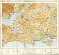
 1673 map of the Severn Estuary.jpg 1 830 × 1 086 ; 1,37 Mio
-
 Aust Ferry landing.jpg 4 000 × 3 000 ; 7,64 Mio
-
 Aust Ferry terminal (disused) - buildings and slipway - geograph.org.uk - 1742858.jpg 4 288 × 2 848 ; 3,02 Mio
-
 AustSevernPowerLine.jpg 640 × 480 ; 89 kio
-
 Bank of the river Severn - geograph.org.uk - 164540.jpg 640 × 480 ; 79 kio
-
 Barry Island Blue Sea.jpg 5 184 × 3 456 ; 9,27 Mio
-
 Bay Colours.jpg 2 800 × 1 575 ; 1,19 Mio
-
 Beachley Point - looking along Severn Estuary - geograph.org.uk - 609756.jpg 640 × 480 ; 65 kio
-
 Beacons in the Severn - geograph.org.uk - 696060.jpg 640 × 480 ; 25 kio
-
 Bedwin Sands, Severn Estuary - geograph.org.uk - 1078441.jpg 640 × 480 ; 45 kio
-
 Black Rock - geograph.org.uk - 1085657.jpg 480 × 640 ; 132 kio
-
 Black Rock Lave Net Heritage Fishery - geograph.org.uk - 346939.jpg 640 × 480 ; 106 kio
-
 Blue Severn Estuary.jpg 5 184 × 3 456 ; 5,06 Mio
-
 Bristol Channel panorama.png 22 196 × 2 120 ; 60,04 Mio
-
 Channels in the mudflats - geograph.org.uk - 332755.jpg 640 × 480 ; 92 kio
-
 Chittening Warth, north of Avonmouth - geograph.org.uk - 916864.jpg 640 × 480 ; 94 kio
-
 Chittening Warth, north of Avonmouth - geograph.org.uk - 916882.jpg 640 × 480 ; 95 kio
-
 Clevedon Marine Lake 3.JPG 2 400 × 1 600 ; 2,01 Mio
-
 Clevedon MMB B4 Steepholm.jpg 4 715 × 2 826 ; 4,07 Mio
-
 Clevedon MMB B6 Steepholm.jpg 4 449 × 2 652 ; 3,46 Mio
-
 Crop of Clapton Moor and surrounding areas from OS One-Inch Sheet 110 1919.jpg 847 × 494 ; 595 kio
-
 December Severn Sunrise.jpg 5 184 × 3 456 ; 4,24 Mio
-
 Deformation of tides in Severn Eatuary.svg 700 × 525 ; 1,36 Mio
-
 Distant Severn Estuary.jpg 5 184 × 3 456 ; 5,14 Mio
-
 Distant Severn Sunrise.jpg 5 184 × 3 456 ; 4,55 Mio
-
Drudwennod Gwarchodfa Natur Genedlaethol Gwlyptir Casnewydd.webm 1 min 39 s, 640 × 360 ; 8,53 Mio
-
 Estuary and Henllys.jpg 5 184 × 3 456 ; 6,1 Mio
-
 Estuary and Willowherb.jpg 5 184 × 3 456 ; 8,55 Mio
-
 Flat Holm and Steep Holm.jpg 5 184 × 3 456 ; 7,31 Mio
-
 FossilBeach7 DMarshall2017.jpg 3 196 × 1 765 ; 1,42 Mio
-
 Friar's Point Sky.jpg 5 184 × 3 456 ; 5,64 Mio
-
 Friar's Point, Barry.jpg 5 472 × 3 648 ; 5,33 Mio
-
 Mudflats near Frampton-on-Severn - geograph.org.uk - 332733.jpg 640 × 480 ; 125 kio
-
 Ogmore Rock Pools.jpg 5 472 × 3 648 ; 6,03 Mio
-
 Ogmore-bySea Rocks.jpg 5 472 × 3 648 ; 5,36 Mio
-
 Ordnance Survey Half-inch Sheet 32 Bristol & Cardiff, Published 1925.jpg 11 928 × 8 911 ; 13,01 Mio
-
 Ordnance Survey One-Inch Sheet 110 Cardiff & Mouth of the Severn, Published 1919.jpg 11 607 × 8 473 ; 35,89 Mio
-
 Ordnance Survey One-Inch Sheet 165 Weston-Super-Mare, Published 1946.jpg 8 197 × 9 554 ; 10,63 Mio
-
 Ordnance Survey Quarter-inch Sheet 16 Southern England, Published 1966.jpg 9 646 × 8 909 ; 12,19 Mio
-
 Over Cwmbran to the Severn.jpg 5 184 × 3 456 ; 7,64 Mio
-
 Penarth Beach Pebbles.jpg 5 472 × 3 648 ; 5,56 Mio
-
 Penarth Cliffs.jpg 5 184 × 3 456 ; 6,82 Mio
-
 Penarth Coast Cloud Formations.jpg 3 456 × 2 592 ; 5,59 Mio
-
 Penarth Coast Early Autumn.jpg 2 539 × 1 904 ; 3,66 Mio
-
 Penarth Coast Low Tide.jpg 5 184 × 3 456 ; 7,32 Mio
-
 Penarth Coast October Clouds.jpg 2 558 × 3 412 ; 5,77 Mio
-
 Penarth Coast September Walk.jpg 5 184 × 3 456 ; 6,02 Mio
-
 Penarth Shore Waves.jpg 5 184 × 3 456 ; 5,26 Mio
-
 Penarth Waves.jpg 5 184 × 3 456 ; 6,25 Mio
-
 Portishead beach and battery point lighthouse panorama 2.png 10 516 × 2 052 ; 28,9 Mio
-
 Portishead beach and battery point lighthouse panorama.png 10 567 × 2 139 ; 35,2 Mio
-
 Portishead beach and Severn Estuary.jpg 5 184 × 3 456 ; 6,91 Mio
-
 Portishead beach panorama.png 9 954 × 1 947 ; 30,27 Mio
-
 Remains of putcher ranks, Severn Estuary - geograph.org.uk - 689099.jpg 640 × 480 ; 183 kio
-
 Remains of putcher ranks, Severn Estuary - geograph.org.uk - 750775.jpg 640 × 480 ; 159 kio
-
 River Severn estuary at Sedbury Cliffs - geograph.org.uk - 1957167.jpg 4 288 × 2 848 ; 6,2 Mio
-

-
 Sedbury Cliff - geograph.org.uk - 157911.jpg 640 × 423 ; 105 kio
-
 Sedbury Cliffs and estuary - geograph.org.uk - 1959584.jpg 4 288 × 2 848 ; 6,88 Mio
-
 Severn and Black Nore.jpg 5 184 × 3 456 ; 5,63 Mio
-
 Severn and Portishead point lighthouse.jpg 5 184 × 3 456 ; 4,79 Mio
-
 Severn Beach and the Second Severn Crossing - geograph.org.uk - 187948.jpg 640 × 465 ; 118 kio
-
 Severn Beach MMB 10 Second Severn Crossing.jpg 1 728 × 2 304 ; 1,78 Mio
-
 Severn Beach MMB 15.jpg 1 728 × 2 304 ; 1,42 Mio
-
 Severn Bridge , Aust Cliff ^ Pylon - geograph.org.uk - 2805308.jpg 4 288 × 2 848 ; 4,72 Mio
-
 Severn Early Autumn.jpg 5 184 × 3 456 ; 7,94 Mio
-
 Severn estuary - geograph.org.uk - 1121180.jpg 640 × 480 ; 68 kio
-
 Severn estuary - geograph.org.uk - 1121185.jpg 640 × 480 ; 68 kio
-
 Severn Estuary - geograph.org.uk - 487131.jpg 640 × 480 ; 66 kio
-
 Severn Estuary and Blaen Bran ResTheSerervoir.jpg 4 000 × 2 666 ; 9,46 Mio
-
 Severn Estuary and Newport.jpg 5 184 × 3 456 ; 5,27 Mio
-

-
 Severn Estuary and Portishead pier.jpg 5 184 × 3 456 ; 5,43 Mio
-
 Severn Estuary and WW1 Bench.jpg 5 184 × 3 456 ; 8,4 Mio
-
 Severn Estuary at Sharpness Old Dock - geograph.org.uk - 103105.jpg 1 600 × 1 200 ; 643 kio
-
 Severn Estuary Autumn Sunset.jpg 5 184 × 3 456 ; 5,16 Mio
-
 Severn Estuary Boats.jpg 5 184 × 3 456 ; 4,87 Mio
-
 Severn Estuary Early Autumn.jpg 5 184 × 3 456 ; 9,39 Mio
-
 Severn Estuary Early October.jpg 5 184 × 3 456 ; 6,32 Mio
-
 Severn Estuary Evening Light.jpg 5 472 × 3 648 ; 4,26 Mio
-
 Severn Estuary from Beechwood.jpg 5 472 × 3 648 ; 6,87 Mio
-
 Severn Estuary from Capel Llwyd.jpg 5 184 × 3 456 ; 6,87 Mio
-
 Severn Estuary from the Woodland.jpg 5 184 × 3 456 ; 7,58 Mio
-
 Severn Estuary lookout point.jpg 1 280 × 960 ; 221 kio
-
 Severn Estuary Panorama Denny Island and Sailboat.jpg 4 608 × 1 229 ; 4,16 Mio
-
 Severn Estuary Panorama.jpg 5 184 × 3 456 ; 4,67 Mio
-
 Severn estuary sands - geograph.org.uk - 1469012.jpg 640 × 480 ; 204 kio
-
 Severn Estuary Sands.JPG 3 264 × 2 448 ; 2,69 Mio
-
 Severn Estuary shoreline including Saul Warth - geograph.org.uk - 90976.jpg 640 × 480 ; 107 kio
-
 Severn Estuary Sunset.jpg 5 184 × 3 456 ; 6,18 Mio
-
 Severn Estuary Turbines.jpg 5 472 × 3 648 ; 7,54 Mio
-
 Severn Estuary View.jpg 5 184 × 3 456 ; 7,89 Mio
-
 Severn Estuary Waves.jpg 5 184 × 3 456 ; 6,34 Mio
-
 Severn Estuary, from Blaen Bran.jpg 5 184 × 3 456 ; 8,19 Mio
-
 Severn estuary. - geograph.org.uk - 1749963.jpg 3 535 × 2 071 ; 1,11 Mio
-
 Severn Estuary.jpg 597 × 400 ; 67 kio
-
 Severn Woods and Clouds.jpg 5 472 × 3 080 ; 6,71 Mio
-

-
-
 South Gloucestershire , River Severn Estuary - geograph.org.uk - 4623313.jpg 4 288 × 2 848 ; 7,41 Mio
-
Spectacular Starlings at Newport Wetlands Nature Reserve, Cymru, Wales.webm 1 min 39 s, 640 × 360 ; 8,49 Mio
-
 Steep Holm September View.jpg 5 184 × 3 456 ; 5,58 Mio
-
 Sudbrook, boulders on Severn foreshore - geograph.org.uk - 696056.jpg 640 × 480 ; 97 kio
-
 The earth and its inhabitants (1882) (14750049706).jpg 2 034 × 1 780 ; 586 kio
-
 The Severn Trow 'Spry', by John Pockett GLW GCIT L358.jpg 800 × 664 ; 73 kio
-
 The top of Gray Hill - geograph.org.uk - 539770.jpg 640 × 411 ; 100 kio
-
 The view from Aust Cliff - geograph.org.uk - 1903454.jpg 3 264 × 2 448 ; 1,69 Mio
-
 View of Chepstow, Wales.jpg 1 883 × 1 150 ; 1,66 Mio
-
 View of Severn Estuary from Newport Wetland's Centre.jpg 7 776 × 1 479 ; 5,62 Mio
-
 Warm Day at Cold Knap.jpg 2 000 × 1 125 ; 643 kio
-
 Welsh Grounds, Severn Estuary - geograph.org.uk - 1078146.jpg 640 × 480 ; 58 kio
-
 Whitmore Bay Sand Trails.jpg 5 320 × 2 946 ; 6,5 Mio


_-_buildings_and_slipway_-_geograph.org.uk_-_1742858.jpg)


_(14750049706).jpg)


