Category:Shepton Mallet
Vai alla navigazione
Vai alla ricerca
small town in Somerset, England  | |||||
| Carica un file multimediale | |||||
| Istanza di | |||||
|---|---|---|---|---|---|
| Luogo | Mendip, Somerset, Sud Ovest dell'Inghilterra, Inghilterra | ||||
| Considerato essere uguale a | Shepton Mallet (pagina Wikimedia duplicata, parrocchia civile dell'Inghilterra) | ||||
| sito web ufficiale | |||||
 | |||||
Sottocategorie
Questa categoria contiene le 14 sottocategorie indicate di seguito, su un totale di 14.
A
- Anglo Trading Estate (6 F)
B
- Babycham (5 F)
C
- Shepton Mallet Carnival (3 F)
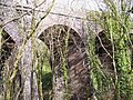
- Charlton Viaduct (19 F)
H
- HM Prison Shepton Mallet (68 F)
K
- Kilver Court (24 F)
M
P
- Pubs in Shepton Mallet (13 F)
File nella categoria "Shepton Mallet"
Questa categoria contiene 200 file, indicati di seguito, su un totale di 451.
(pagina precedente) (pagina successiva)-
 'Countess' - geograph.org.uk - 4182399.jpg 1 704 × 2 304; 1,71 MB
-
 'The Duke of Windsor' - geograph.org.uk - 4182424.jpg 1 704 × 2 304; 1,48 MB
-
 2011 , A361 Charlton Road, Shepton Mallet - geograph.org.uk - 2462953.jpg 3 464 × 2 850; 3,44 MB
-
 2011 , A37 at the Beardy Batch roundabout - geograph.org.uk - 2566934.jpg 4 640 × 2 631; 3,17 MB
-
 2011 , A37 roundabout at Beardly Batch - geograph.org.uk - 2568186.jpg 3 297 × 2 324; 2,47 MB
-
 2011 , A37 Whitstone Road south from Shepton Mallet - geograph.org.uk - 2496300.jpg 4 300 × 2 529; 3,83 MB
-
 2011 , A37 Whitstone Road, Shepton Mallet - geograph.org.uk - 2491112.jpg 4 252 × 2 929; 4,39 MB
-
 2011 , A371 a bypassed portion or it could have been the A37 - geograph.org.uk - 2566904.jpg 4 752 × 3 168; 6,81 MB
-
 2011 , A371 about to enter Shepton Mallet - geograph.org.uk - 2464231.jpg 1 600 × 1 327; 892 KB
-
 2011 , A371 Commercial Road, Shepton Mallet - geograph.org.uk - 2464123.jpg 3 292 × 2 552; 2,8 MB
-
 2011 , A371 heading down Pike Hill skirting Shepton Mallet - geograph.org.uk - 2464111.jpg 3 783 × 2 936; 4,16 MB
-
 2011 , A371 passing Darshill heading west - geograph.org.uk - 2464211.jpg 3 371 × 2 658; 4,25 MB
-
 2011 , Bolter's Lane looking east - geograph.org.uk - 2419011.jpg 3 604 × 2 856; 4,61 MB
-
 2011 , Bolter's Lane looking west - geograph.org.uk - 2418947.jpg 3 850 × 2 505; 4,04 MB
-
 2011 , Charlton Road, Shepton Mallet - geograph.org.uk - 2457597.jpg 4 393 × 3 168; 5,6 MB
-
 2011 , Darshill, west of Shepton Mallet - geograph.org.uk - 2457760.jpg 3 828 × 2 920; 4,58 MB
-
 2011 , East of north from the A361 - geograph.org.uk - 2494636.jpg 4 509 × 2 075; 2,81 MB
-
 2011 , Farm track and sheep on Whitstone Hill - geograph.org.uk - 2548798.jpg 4 052 × 2 072; 3,02 MB
-
 2011 , Farm track north of Bolter's Lane - geograph.org.uk - 2388793.jpg 4 241 × 2 724; 5,17 MB
-
 2011 , Farm track on dismantled railway - geograph.org.uk - 2419220.jpg 4 122 × 2 790; 5,78 MB
-
 2011 , Footpath to Shepton Mallet - geograph.org.uk - 2419071.jpg 4 121 × 2 168; 3,52 MB
-
 2011 , Fosse Lane Trading Estate, Shepton Mallet - geograph.org.uk - 2462987.jpg 3 484 × 2 512; 1,98 MB
-
 2011 , From Bolter's Lane, looking toward Downside - geograph.org.uk - 2419049.jpg 4 175 × 2 361; 2,92 MB
-
 2011 , Gate to a wheatfield south of Shepton Mallet - geograph.org.uk - 2568201.jpg 4 191 × 2 630; 3,35 MB
-
 2011 , Ice Road Truckers coming to Shepton Mallet - geograph.org.uk - 2496345.jpg 3 170 × 2 288; 3,41 MB
-
 2011 , North east on Forum Lane - geograph.org.uk - 2419228.jpg 4 021 × 2 745; 3,33 MB
-
 2011 , North of north of west from Whitstone Hill - geograph.org.uk - 2560183.jpg 2 885 × 1 948; 2,16 MB
-
 2011 , North of west from Whitstone Hill - geograph.org.uk - 2560147.jpg 4 740 × 2 403; 4,02 MB
-
 2011 , North west from Whitstone Hill - geograph.org.uk - 2560116.jpg 4 752 × 2 597; 3,79 MB
-
 2011 , On Windsor Hill, toward Lower Downside - geograph.org.uk - 2388816.jpg 4 553 × 2 267; 3,45 MB
-
 2011 , Pasture with trees north of Shepton Mallet - geograph.org.uk - 2418957.jpg 3 767 × 2 782; 5,16 MB
-
 2011 , Ramblers on Bolter's Lane - geograph.org.uk - 2419000.jpg 2 933 × 2 467; 2,58 MB
-
 2011 , Shaftgate Avenue, Shepton Mallet - geograph.org.uk - 2457748.jpg 3 830 × 2 949; 3,89 MB
-
 2011 , South west from Whitstone Hill - geograph.org.uk - 2560104.jpg 4 727 × 2 405; 3,48 MB
-
 2011 , Westleigh Gardens, Shepton Mallet - geograph.org.uk - 2464077.jpg 3 813 × 2 583; 2,81 MB
-
 2011 , Winter wheat seen from Bolter's Lane - geograph.org.uk - 2388773.jpg 4 294 × 2 280; 3,8 MB
-
 27 Peter Street, Shepton Mallett (geograph 6989806).jpg 1 024 × 768; 148 KB
-
 65 High Street (geograph 7559033).jpg 1 024 × 678; 720 KB
-
 A bit fell off - geograph.org.uk - 3993825.jpg 1 704 × 2 304; 1,92 MB
-
 A little maintenance - geograph.org.uk - 4182394.jpg 2 304 × 1 704; 1,82 MB
-
 A straight yard - geograph.org.uk - 3104693.jpg 2 304 × 1 704; 1,79 MB
-
 A stroll for some eggs - geograph.org.uk - 3993037.jpg 2 304 × 1 704; 1,54 MB
-
 A tall chimney - geograph.org.uk - 3126958.jpg 1 704 × 2 304; 1,72 MB
-
 A wet trot - geograph.org.uk - 3992998.jpg 1 704 × 2 304; 1,86 MB
-
 A37 Bath Road looking north - geograph.org.uk - 5817325.jpg 1 024 × 729; 107 KB
-
 A37 bypassing Shepton Mallet - geograph.org.uk - 5473548.jpg 1 600 × 1 196; 727 KB
-
 A37 northbound - geograph.org.uk - 3022672.jpg 640 × 480; 58 KB
-
 A37 northbound - geograph.org.uk - 3022749.jpg 640 × 480; 52 KB
-

-
 A37 northbound, Charlton crossroads - geograph.org.uk - 3022667.jpg 640 × 441; 56 KB
-
 A371 Wells Road - geograph.org.uk - 5817296.jpg 1 024 × 705; 196 KB
-
 All things automotive - geograph.org.uk - 3108519.jpg 2 304 × 1 704; 1,3 MB
-
 Alley ways Shepton Mallet.jpg 1 024 × 768; 229 KB
-
 Alleyway Shepton Mallet - geograph.org.uk - 2278110.jpg 640 × 487; 121 KB
-
 Alleyway, Town Street, Shepton Mallet (geograph 7387958).jpg 2 848 × 4 288; 2,47 MB
-
 Along the lane - geograph.org.uk - 3992488.jpg 2 304 × 1 704; 1,74 MB
-
 Ambulance station - geograph.org.uk - 3109398.jpg 2 304 × 1 704; 1,43 MB
-
 An early version of a prancing horse - geograph.org.uk - 4182403.jpg 1 704 × 2 304; 1,44 MB
-
 An old benchmark on an old brewery - geograph.org.uk - 3136740.jpg 1 704 × 2 304; 2,03 MB
-
 An old house in Cowl Street - geograph.org.uk - 3992564.jpg 2 304 × 1 704; 1,79 MB
-
 An old mark - geograph.org.uk - 3990727.jpg 1 704 × 2 304; 2,22 MB
-
 An original taste of history - geograph.org.uk - 3116886.jpg 1 704 × 2 304; 1,5 MB
-
 And not a mile an hour more - geograph.org.uk - 3992982.jpg 1 704 × 2 304; 2,16 MB
-
 Appliance of water - geograph.org.uk - 4182460.jpg 2 304 × 1 704; 1,75 MB
-

-

-
-
 Assembly Room, Shepton Mallett (geograph 6989992).jpg 1 024 × 768; 119 KB
-
 Avenue of trees - geograph.org.uk - 3147721.jpg 2 304 × 1 704; 1,64 MB
-
 B3136 Rectory Road, Shepton Mallet - geograph.org.uk - 5817309.jpg 1 024 × 666; 166 KB
-
 B3136 Waterloo Road at Shepton Mallet viaduct - geograph.org.uk - 5817319.jpg 1 024 × 735; 137 KB
-
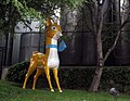 Babycham fawn SheptonMallet.jpg 2 034 × 1 572; 945 KB
-
 Barn Owl - geograph.org.uk - 3188415.jpg 1 704 × 2 304; 1,38 MB
-
 Been here again - geograph.org.uk - 3099890.jpg 1 704 × 2 304; 1,4 MB
-
 Bench Mark, Cowl Street - geograph.org.uk - 2612951.jpg 480 × 640; 92 KB
-
 Benchmark in Great Ostry - geograph.org.uk - 3100427.jpg 1 704 × 2 304; 2,09 MB
-
 Benchmark in Peter Street - geograph.org.uk - 3123201.jpg 1 704 × 2 304; 1,96 MB
-
 Benchmark in the High Street - geograph.org.uk - 3100382.jpg 2 304 × 1 704; 1,68 MB
-
 Benchmark on East Somerset House - geograph.org.uk - 3990753.jpg 1 704 × 2 304; 2,12 MB
-
 Benchmark on Eastfield - geograph.org.uk - 3991018.jpg 2 304 × 1 704; 1,65 MB
-
 Benchmark on the nick - geograph.org.uk - 3126921.jpg 1 704 × 2 304; 2,04 MB
-
 Benchmark on Town Lane - geograph.org.uk - 3136729.jpg 2 304 × 1 704; 1,71 MB
-
 Big rig - geograph.org.uk - 3188470.jpg 1 704 × 2 304; 2,02 MB
-
 Bio security measures - geograph.org.uk - 4182485.jpg 2 304 × 1 704; 1,67 MB
-
 Blackthorn Cider - geograph.org.uk - 2870016.jpg 640 × 480; 64 KB
-
 Bluebells and the bridge - geograph.org.uk - 3993023.jpg 2 304 × 1 704; 1,59 MB
-
 Bolter's Lane - geograph.org.uk - 5643079.jpg 640 × 480; 191 KB
-
 Bowditch Close - geograph.org.uk - 3994192.jpg 2 304 × 1 704; 1,56 MB
-
 Bowlish Grange (geograph 7387978).jpg 4 175 × 2 705; 1,43 MB
-
 Bowlish Villa (geograph 7388168).jpg 4 041 × 2 693; 1,08 MB
-
 Box on the green - geograph.org.uk - 3992949.jpg 2 304 × 1 704; 1,77 MB
-
 Brewery Arch - geograph.org.uk - 3136760.jpg 2 304 × 1 704; 1,74 MB
-
 Bridge and gates - geograph.org.uk - 3116891.jpg 1 704 × 2 304; 1,52 MB
-
 Bridge made of many parts - geograph.org.uk - 3990977.jpg 2 304 × 1 704; 1,64 MB
-
 Bridge on Cowl Street - geograph.org.uk - 2612917.jpg 640 × 480; 80 KB
-
 Bridge over Kilver Street - geograph.org.uk - 3116869.jpg 2 304 × 1 704; 1,36 MB
-
 British as a bulldog - geograph.org.uk - 4182483.jpg 1 704 × 2 304; 1,63 MB
-
 British blood and bite - geograph.org.uk - 3992976.jpg 1 704 × 2 304; 1,52 MB
-
 Bunking off^ - geograph.org.uk - 3147730.jpg 2 304 × 1 704; 1,63 MB
-
 Busy roundabout - geograph.org.uk - 3104702.jpg 2 304 × 1 704; 1,45 MB
-
 Cadet Force Drill Hall - Drill Hall Lane - geograph.org.uk - 4173585.jpg 1 600 × 1 064; 335 KB
-
 Cannards Well public house - geograph.org.uk - 5531034.jpg 640 × 427; 77 KB
-
 Catching the judges' eyes - geograph.org.uk - 4182516.jpg 2 304 × 1 704; 1,81 MB
-
 Caught in the spotlight - geograph.org.uk - 3147719.jpg 2 304 × 1 704; 1,65 MB
-
 Charlton House Hotel - geograph.org.uk - 1196362.jpg 640 × 480; 74 KB
-
 Charlton Trading Estate - geograph.org.uk - 5227750.jpg 640 × 480; 128 KB
-
 Charlton Trading Estate - geograph.org.uk - 5227759.jpg 640 × 480; 125 KB
-
 Charlton Trading Estate - geograph.org.uk - 5227770.jpg 640 × 480; 116 KB
-
 Charlton Trading Estate - geograph.org.uk - 5227809.jpg 640 × 480; 67 KB
-
 Charlton Trading Estate - geograph.org.uk - 5227815.jpg 640 × 480; 104 KB
-
 Chimney in garden at Kilver Court Designer Village - geograph.org.uk - 5845856.jpg 3 672 × 4 896; 6,02 MB
-
 Chrome everywhere - geograph.org.uk - 4182511.jpg 2 304 × 1 704; 1,71 MB
-
 Church Walk - geograph.org.uk - 6155088.jpg 3 024 × 4 032; 2,61 MB
-
 Collett Park - geograph.org.uk - 3147725.jpg 2 304 × 1 704; 1,67 MB
-
 Collett Park birdcages - geograph.org.uk - 3147733.jpg 2 304 × 1 704; 1,61 MB
-
 Coming soon^ - geograph.org.uk - 3104754.jpg 2 304 × 1 704; 1,72 MB
-
 Coming up Pike Hill - geograph.org.uk - 3992453.jpg 2 304 × 1 704; 1,78 MB
-

-
 Compton Lane, looking north - geograph.org.uk - 5513877.jpg 640 × 480; 180 KB
-
 Council Offices - geograph.org.uk - 3059904.jpg 2 304 × 1 704; 1,7 MB
-
 Cowl Street benchmark - geograph.org.uk - 3992557.jpg 1 704 × 2 304; 2,13 MB
-
 Cowl Street, Shepton Mallet - geograph.org.uk - 1951739.jpg 640 × 480; 61 KB
-
 Cowl Street, Shepton Mallet - geograph.org.uk - 2612981.jpg 480 × 640; 68 KB
-
 Crimefighters^ - geograph.org.uk - 3188460.jpg 2 304 × 1 704; 1 MB
-
 Crossroads at Downside - geograph.org.uk - 5531828.jpg 640 × 427; 83 KB
-
 Cyprus Villas - geograph.org.uk - 3990721.jpg 2 304 × 1 704; 1,66 MB
-
 Darshill and the river Sheppey - geograph.org.uk - 191562.jpg 640 × 480; 127 KB
-

-

-
 Disused footbridge over a disused railway - geograph.org.uk - 222751.jpg 600 × 450; 144 KB
-
 Do I get a rosette thingy^ - geograph.org.uk - 4182492.jpg 2 304 × 1 704; 1,64 MB
-
 Don't go down into the crypt^ - geograph.org.uk - 3110340.jpg 1 704 × 2 304; 1,69 MB
-
 Downside House - geograph.org.uk - 5352655.jpg 640 × 428; 109 KB
-
 Draycott Road - geograph.org.uk - 3992536.jpg 2 304 × 1 704; 1,79 MB
-
 Dredge ^ Male, Shepton Mallet - geograph.org.uk - 2053461.jpg 584 × 640; 84 KB
-
 Dug in - geograph.org.uk - 4182477.jpg 1 704 × 2 304; 1,7 MB
-
 Empty Woolworths store Townsend, Shepton Mallet - geograph.org.uk - 1751143.jpg 1 944 × 2 592; 951 KB
-

-
 Entrance to the cemetery - geograph.org.uk - 5513883.jpg 640 × 480; 162 KB
-
 Entrance to the hall - geograph.org.uk - 3100447.jpg 2 304 × 1 704; 1,48 MB
-
 Feature in Collett Park - geograph.org.uk - 3104664.jpg 1 704 × 2 304; 1,91 MB
-
 Fields near Charlton Viaduct - geograph.org.uk - 1528107.jpg 640 × 480; 86 KB
-
 Fire Station - geograph.org.uk - 3108525.jpg 2 304 × 1 704; 1,33 MB
-
 First Prize - geograph.org.uk - 3188491.jpg 2 304 × 1 704; 1,26 MB
-
 Flush Bracket - geograph.org.uk - 3059896.jpg 2 304 × 1 704; 1,62 MB
-
 Footbridge over the Sheppey - geograph.org.uk - 3993977.jpg 2 304 × 1 704; 1,81 MB
-
 Footpath to Barren Down - geograph.org.uk - 3993996.jpg 1 704 × 2 304; 1,94 MB
-
 Ford FW-30 tractor - geograph.org.uk - 572933.jpg 640 × 480; 84 KB
-
 Ford FW-30 tractor - geograph.org.uk - 572968.jpg 640 × 480; 118 KB
-
 Fosse Lane, Shepton Mallet - geograph.org.uk - 5709874.jpg 2 304 × 1 728; 1,71 MB
-
 Fosse Way near Shepton Mallet - geograph.org.uk - 498380.jpg 480 × 640; 154 KB
-
 Fried Fish, Chip Potatoes - geograph.org.uk - 4196546.jpg 3 464 × 3 000; 1,55 MB
-
 Funeral Directors on West Shepton - geograph.org.uk - 3990743.jpg 2 304 × 1 704; 1,63 MB
-
 Garden Centre Car Park - geograph.org.uk - 5222145.jpg 640 × 360; 37 KB
-
 Gardner power - geograph.org.uk - 4182471.jpg 2 304 × 1 704; 1,57 MB
-

-

-
 Gaymers Factory, Shepton Mallet - geograph.org.uk - 2060032.jpg 640 × 480; 188 KB
-
 Gaymers offices, Shepton Mallet - geograph.org.uk - 2055311.jpg 640 × 480; 61 KB
-
 Geograph 3441606 Bowlish House, Shepton Mallet.jpg 640 × 409; 177 KB
-
 Growing their own - geograph.org.uk - 3136812.jpg 1 704 × 2 304; 2,09 MB
-
 Ham Lane - geograph.org.uk - 5352664.jpg 640 × 480; 200 KB
-
 Ham Woods Viaduct.jpg 1 024 × 768; 231 KB
-
 Happy to be behind bars - geograph.org.uk - 3992955.jpg 2 304 × 1 704; 1,68 MB
-
 Helpful benchmark - geograph.org.uk - 3100350.jpg 1 704 × 2 304; 1,68 MB
-
 Helping the work - geograph.org.uk - 4182384.jpg 2 304 × 1 704; 1,63 MB
-
 Hiding Dove - geograph.org.uk - 3112502.jpg 1 704 × 2 304; 1,27 MB
-
 High St Shepton Mallet - geograph.org.uk - 2278112.jpg 640 × 480; 66 KB
-
 High Street bank - geograph.org.uk - 3100355.jpg 1 704 × 2 304; 1,41 MB
-
 High Street shops - geograph.org.uk - 3100373.jpg 2 304 × 1 704; 1,53 MB
-
 High Street, Shepton Mallet - geograph.org.uk - 2412441.jpg 1 024 × 768; 157 KB
-
 High Street, Shepton Mallet - geograph.org.uk - 5373229.jpg 640 × 427; 55 KB
-
 High vision - geograph.org.uk - 3099877.jpg 1 704 × 2 304; 1,16 MB
-
 Housing at Cannards Grave - geograph.org.uk - 5531709.jpg 640 × 427; 69 KB
-
 HSBC Shepton Mallet - geograph.org.uk - 2053476.jpg 640 × 480; 75 KB
-
 Island life - geograph.org.uk - 3147728.jpg 1 704 × 2 304; 2,15 MB
-
 Judge's decision is final - geograph.org.uk - 3188408.jpg 1 704 × 2 304; 1,39 MB
-
-
 Junction, Ham Lane (geograph 7388207).jpg 3 507 × 2 157; 1,36 MB
-
 Just a little smile, then - geograph.org.uk - 4181632.jpg 2 304 × 1 704; 1,66 MB
-
 Just in case you didn't know - geograph.org.uk - 3993793.jpg 1 704 × 2 304; 1,76 MB
-
 Keeping out of the water - geograph.org.uk - 3993958.jpg 1 704 × 2 304; 1,71 MB
-
 Kilver Street, Shepton Mallet - geograph.org.uk - 2055250.jpg 640 × 480; 62 KB
-
 Landies all over the field - geograph.org.uk - 4182427.jpg 2 304 × 1 704; 1,7 MB
-
 Lloyds TSB Shepton Mallet - geograph.org.uk - 2053442.jpg 640 × 480; 77 KB
-
 Long way up - geograph.org.uk - 3993840.jpg 1 704 × 2 304; 1,53 MB
-
 Longbridge Cottage - geograph.org.uk - 3993936.jpg 2 304 × 1 704; 1,72 MB
-
 Looking east-northeast along the High Street - geograph.org.uk - 4938968.jpg 3 264 × 2 448; 1,6 MB
-
 Looking from the bridge (geograph 3108517).jpg 2 304 × 1 704; 1,61 MB
-
 Looking north-northeast from Hill Lane - geograph.org.uk - 4938940.jpg 3 264 × 2 448; 2,25 MB
-
 Looking northeast along the High Street - geograph.org.uk - 4938951.jpg 2 448 × 3 264; 1,97 MB
-
 Looking up Peter Street - geograph.org.uk - 3123206.jpg 2 304 × 1 704; 1,72 MB
-
 Lovely drop of stuff - geograph.org.uk - 4182381.jpg 2 304 × 1 704; 1,3 MB
-
 Lower Lane, Shepton Mallet - geograph.org.uk - 2053699.jpg 640 × 480; 96 KB
-
 Make sure you're standing to attention - geograph.org.uk - 4182378.jpg 1 704 × 2 304; 1,88 MB
-
 Mendip Council car park - geograph.org.uk - 3108515.jpg 2 304 × 1 704; 1,67 MB
-
 Messenger of peace - geograph.org.uk - 3112524.jpg 1 704 × 2 304; 1,4 MB
-
 MidSomerset Show 170803.jpg 1 600 × 1 200; 787 KB
-
 Millennium stone - geograph.org.uk - 3109435.jpg 1 704 × 2 304; 2,01 MB
-
 Mulberry Factory Shop Sign - geograph.org.uk - 2060027.jpg 427 × 640; 164 KB


.jpg)
.jpg)


.jpg)


.jpg)
.jpg)


.jpg)
.jpg)


.jpg)


.jpg)


