Category:Sherman County, Oregon
둘러보기로 이동
검색으로 이동
Counties of Oregon: Baker · Benton · Clackamas · Clatsop · Columbia · Coos · Crook · Curry · Deschutes · Douglas · Gilliam · Grant · Harney · Hood River · Jackson · Jefferson · Josephine · Klamath · Lake · Lane · Lincoln · Linn · Malheur · Marion · Morrow · Multnomah · Polk · Sherman · Tillamook · Umatilla · Union · Wallowa · Wasco · Washington · Wheeler · Yamhill
county in Oregon, United States   | |||||
| 미디어 올리기 | |||||
| 다음 종류에 속함 | |||||
|---|---|---|---|---|---|
| 명칭의 유래 | |||||
| 위치 | 오리건주, 미국 | ||||
| 정부 소재지 | |||||
| 만들어진 날 |
| ||||
| 인구수 |
| ||||
| 면적 |
| ||||
| 다음과 다름 | |||||
| 공식 웹사이트 | |||||
 | |||||
하위 분류
다음은 이 분류에 속하는 하위 분류 16개 가운데 16개입니다.
B
C
- Cottonwood Canyon State Park (66 F)
D
G
- Grass Valley, Oregon (8 F)
I
- Interstate 80N in Oregon (1 F)
M
P
R
- Rufus, Oregon (15 F)
S
- Sam Hill Memorial Bridge (15 F)
W
- Wasco, Oregon (9 F)
"Sherman County, Oregon" 분류에 속하는 미디어
다음은 이 분류에 속하는 파일 37개 가운데 37개입니다.
-

-
 1500 sheep in Sherman County, Oregon (3229816482).jpg 4,570 × 3,390; 7.61 MB
-
 1966 Wildcat Canyon archaeological project information sheets, page 1 (1604571372).jpg 1,903 × 2,379; 1.24 MB
-
 1966 Wildcat Canyon archaeological project information sheets, page 2 (1603751587).jpg 1,770 × 2,303; 1.35 MB
-

-

-
 Archaeology below the water table, Wildcat Canyon, Oregon (USA), 1966 (1808159157).jpg 2,043 × 1,307; 1.02 MB
-
 Bikers by a menhir at Maryhill Stonehenge.jpg 4,288 × 2,848; 5.77 MB
-
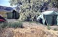 Camp at 1966 Wildcat Canyon (Oregon, USA) archaeological project (1808154343).jpg 2,043 × 1,307; 1.25 MB
-

-
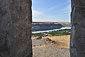 Columbia River from Maryhill Stonehenge 02.jpg 4,288 × 2,848; 7 MB
-
 Cooperative buying of fuel in Sherman County, ca. 1919 (5688031424).jpg 1,000 × 586; 96 KB
-

-

-
 Deschutes wildflowers - OR - 2002.04.20.png 717 × 480; 789 KB
-
 Get rich quick in archaeology? (1679261572).jpg 1,362 × 1,214; 455 KB
-
 Harvest time (9322925938).jpg 1,728 × 1,152; 2.22 MB
-
 Kent-Sherman Counties Dairy calf club; C.E. English, local leader (5834183050).jpg 3,140 × 2,307; 505 KB
-
 Maggie Eaton (Twenty eventful years, 1904).png 516 × 664; 566 KB
-
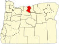 Map of Oregon highlighting Sherman County.svg 1,433 × 1,069; 104 KB
-
 Maryhill Stonehenge 10.jpg 4,288 × 2,848; 6.37 MB
-
 Maryhill Stonehenge 12.jpg 2,848 × 4,288; 6.33 MB
-
 Maryhill Stonehenge 14.jpg 4,288 × 2,848; 6.3 MB
-
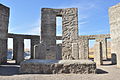 Maryhill Stonehenge 16.jpg 4,288 × 2,848; 6.88 MB
-
 Maryhill Stonehenge 360 pano 01.jpg 14,760 × 1,728; 6.37 MB
-
 Maryhill WA.jpg 4,473 × 1,905; 4.17 MB
-
 Men filling up oil drums, Sherman County, ca. 1919 (5688031618).jpg 1,000 × 569; 142 KB
-
 Nature and technology in harmony.jpg 4,032 × 3,024; 2.42 MB
-
 Old buildings next to the Columbia River (Oregon, USA), 1966 (1808804813).jpg 2,043 × 1,307; 806 KB
-

-
 Sherars Bridge.jpg 3,456 × 2,592; 3.17 MB
-

-
 Then and Now, John Day Dam, Columbia River (8100848016).jpg 800 × 249; 60 KB
-

-
-

-
 USA Sherman, Oregon age pyramid.svg 520 × 600; 8 KB
_(1074322614).jpg)
.jpg)
.jpg)
.jpg)
,_1966_(427458549).jpg)
_(1073454403).jpg)
,_1966_(1808159157).jpg)

_archaeological_project_(1808154343).jpg)
_taken_from_the_Oregon_side_looking_toward_the_Washington_side,_1966_(1806534285).jpg)

.jpg)
_(1808706389).jpg)
.jpg)

.jpg)
.jpg)
.jpg)
.png)


.jpg)

,_1966_(1808804813).jpg)
.jpg)

,_archaeological_site._(488474677).jpg)
_1966_(2489285321).jpg)
_1966_(457921841).jpg)
_1966_(457923233).jpg)

.jpg)