Category:Sills (geology)
Направо към навигацията
Направо към търсенето
A tabular sheet intrusion that has intruded between older layers of sedimentary rock, beds of volcanic lava or tuff, or along the direction of foliation in metamorphic rock  Salisbury Crags a Edimburg, Escòcia, una intrusió magmàtica parcialment exposada durant l'Edat de Gel | |||||
| Качване на файл | |||||
| Подклас на | |||||
|---|---|---|---|---|---|
| |||||
Подкатегории
Показани са 10 от общо 10 подкатегории на тази категория.
- Sills (geology) in Madeira (0 К, 0 С, 25 Ф)
'
+
- Diagrams of sills (geology) (0 К, 0 С, 9 Ф)
A
B
- Burned Mountain Formation (0 К, 0 С, 2 Ф)
C
Файлове в категория „Sills (geology)“
Показани са 53 от общо 53 файла в тази категория.
-

-
 Baffin Island glacier and peg swarm.jpg 2400 × 2008; 2,22 МБ
-
 Basement Sill at Bull Pass in McMurdo Dry Valleys in Antarctica.jpg 1280 × 961; 112 КБ
-
 Bergspitze auf Madeira, von Dykes zusammengehalten.jpg 5184 × 3456; 7,54 МБ
-
 Crater Lake Pumice Castle.jpg 3072 × 2048; 5,77 МБ
-
 Detalle Laguna Azul (Santa Cruz).jpg 2048 × 1536; 851 КБ
-
 Diatrema 2.jpg 1138 × 1080; 76 КБ
-
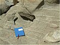
 Doleritesillundermudstone.jpg 1280 × 1024; 484 КБ
-
 Emplacementstructures.png 2048 × 2048; 385 КБ
-
 Filoni.jpg 1315 × 914; 80 КБ
-
 GQ6A9689.JPG 5760 × 3840; 7,57 МБ
-
 Grinnell and The Salamander Glaciers in 1911.jpg 1400 × 810; 718 КБ
-
 Grinnell Glacier in Summer.jpg 2048 × 676; 320 КБ
-
 Iceberg Lake (4158171296).jpg 1200 × 1600; 764 КБ
-
 Iceberg Lake Ridge (4158171784).jpg 1600 × 1067; 675 КБ
-
 Iceland Landscape 4560.JPG 3264 × 2448; 3,62 МБ
-
 Intrusion types.svg 1180 × 1263; 72 КБ
-
 Isay - geological dyke - geograph.org.uk - 825462.jpg 640 × 480; 93 КБ
-
 Karoo Koppies.png 4160 × 1148; 5,93 МБ
-
 Laccolithformation.png 1640 × 2360; 477 КБ
-
 Laccolithformationmechanism.png 1640 × 2360; 512 КБ
-
 Last Chance Range Nevada 2.jpg 2400 × 1600; 796 КБ
-
 Layered Websterite in Basement Sill in McMurdo Dry Valleys in Antarctica.jpg 1280 × 961; 259 КБ
-
 Metamorphic Aureole in the Henry Mountains.JPG 3648 × 2736; 2,87 МБ
-
 Mountains towering over Aappilattoq, 2017.jpg 1080 × 1920; 415 КБ
-
 Novarupta and Baked Mtn. (13542730745).jpg 4000 × 3000; 4,13 МБ
-
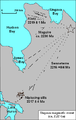
 Palisades Sill Location Map.jpg 634 × 460; 85 КБ
-
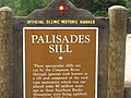 Palisades Sill sign near Cimarron, NM Picture 2023.jpg 2592 × 1944; 1,21 МБ
-
 PanoramaSanTorini.jpg 1200 × 418; 187 КБ
-
 Pluton types.png 2048 × 2048; 251 КБ
-
 Reunion Mafate sill.JPG 3872 × 2592; 3,58 МБ
-
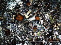 Sainte Dorothee XP.jpg 2048 × 1536; 1,9 МБ
-
 Salisbury Crags, Holyrood Park - geograph.org.uk - 1712953.jpg 800 × 600; 104 КБ
-
 Secord Peak (Rakaposhi).jpg 2560 × 1920; 1,11 МБ
-
 Sill at river Måna, Rjukan - Cellerterskel ved Måna på Rjukan (6302484830).jpg 3331 × 2208; 1,17 МБ
-
 Sill in Nahal Ramon 2.jpg 4378 × 3284; 4,38 МБ
-
 Sill in Nahal Ramon.jpg 4378 × 3284; 4,06 МБ
-
 Sill Northern Nevada.JPG 3072 × 2304; 3,01 МБ
-
 Sill Sainte Dorothee.jpg 2048 × 1536; 701 КБ
-
 Sill-en.svg 702 × 333; 7 КБ
-
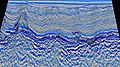 Sills in Rockall Trough.jpg 3840 × 2160; 2,57 МБ
-
 Sills.png 2360 × 1640; 447 КБ
-
 Sillstype.svg 744 × 1052; 605 КБ
-
 Sled dogs on sea ice in North Star Bay near Thule Air Base, Greenland.jpg 3200 × 560; 480 КБ
-
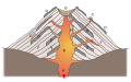 Stratovolcano cross-section.svg 744 × 460; 184 КБ
-
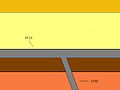 The difference between a sill and a dike.jpg 512 × 384; 11 КБ
-
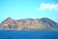 Torishima 07 02.jpg 1500 × 1000; 273 КБ
-
 TPIC mafic sill complex.jpg 3008 × 1987; 883 КБ
-
 Ungava magmatic event.png 346 × 547; 22 КБ
-
 Uummannaq-mountain-southern-wall.jpg 3872 × 2176; 3,5 МБ
-
 Volcanic plumbing systems.png 2360 × 1640; 635 КБ
-
 Vágseiði and Vágur.1.jpg 3872 × 2592; 2,34 МБ
-
 Кальдера вулкана Горелый 346.jpg 3264 × 2448; 3,42 МБ
.jpg)


.jpg)


.jpg)
.jpg)


.jpg)


.jpg)
.jpg)


