Category:Sockbridge and Tirril
Aller à la navigation
Aller à la recherche
localité britannique du comté anglais de Cumbria  | |||||
| Téléverser des médias | |||||
| Nature de l’élément | |||||
|---|---|---|---|---|---|
| Lieu | Eden, Cumbria, Angleterre du Nord-Ouest, Angleterre | ||||
 | |||||
English: Sockbridge and Tirril is a small civil parish in Eden District, Cumbria comprising the adjoining settlements of Tirril, Sockbridge and Thorpe. All three were once separate places but are now, in effect, a single village.
Média dans la catégorie « Sockbridge and Tirril »
Cette catégorie comprend 51 fichiers, dont les 51 ci-dessous.
-
 176 metre spot height, Margate Cross, Tirril - geograph.org.uk - 4683790.jpg 1 024 × 768 ; 120 kio
-
 Agricultural merchants at Tirril - geograph.org.uk - 4023427.jpg 640 × 480 ; 483 kio
-
 At the sign of the Queens Head, Tirril - geograph.org.uk - 4683757.jpg 1 024 × 768 ; 166 kio
-
 Birds flying over farmland, south-east of Celleron - geograph.org.uk - 4692404.jpg 1 024 × 614 ; 94 kio
-
 Boundary Post - geograph.org.uk - 1718707.jpg 427 × 640 ; 322 kio
-
 Bus stops on the B5320, Tirril - geograph.org.uk - 4683762.jpg 1 024 × 614 ; 128 kio
-
 Cast Iron Boundary Post - geograph.org.uk - 1718699.jpg 640 × 427 ; 291 kio
-
 Celleron Farm - geograph.org.uk - 6120250.jpg 640 × 480 ; 301 kio
-
 Converted chapel in Tirril - geograph.org.uk - 6402731.jpg 2 700 × 2 025 ; 677 kio
-
 Country lane near Tirril - geograph.org.uk - 4023424.jpg 640 × 480 ; 565 kio
-
 Drystone wall, east side of the B5320 - geograph.org.uk - 4682752.jpg 768 × 1 024 ; 545 kio
-
 Field of polythene strips, near Tirril - geograph.org.uk - 4024257.jpg 640 × 480 ; 560 kio
-
 Fields and trees near Glendowlin - geograph.org.uk - 6120534.jpg 640 × 480 ; 276 kio
-
 Fields by the Yanwath to Askham road - geograph.org.uk - 4024259.jpg 640 × 480 ; 454 kio
-
 Gate and stone wall - geograph.org.uk - 6120481.jpg 640 × 480 ; 311 kio
-
 Highfield Farm - geograph.org.uk - 4024256.jpg 640 × 480 ; 505 kio
-
 Highfield Plantation - geograph.org.uk - 3052548.jpg 640 × 480 ; 135 kio
-
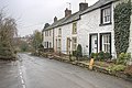
 Houses in Tirril (1) - geograph.org.uk - 4683774.jpg 1 024 × 768 ; 123 kio
-
 Houses in Tirril.jpg 1 024 × 614 ; 117 kio
-
 Large bare field, north of Limekiln Plantation (1) - geograph.org.uk - 4692371.jpg 1 024 × 768 ; 103 kio
-
 Large bare field, north of Limekiln Plantation (2) - geograph.org.uk - 4692375.jpg 1 024 × 768 ; 102 kio
-
 Large bare field, north of Limekiln Plantation (3) - geograph.org.uk - 4692379.jpg 1 024 × 768 ; 113 kio
-
 Looking east from the layby on the B5320 - geograph.org.uk - 4683787.jpg 1 024 × 768 ; 143 kio
-
 Minor road south-east from the B5320 - geograph.org.uk - 4682756.jpg 1 024 × 768 ; 115 kio
-
 Narrow road to Celleron - geograph.org.uk - 3052558.jpg 640 × 480 ; 63 kio
-
 New houses at Broad Ing Farm - geograph.org.uk - 6120257.jpg 640 × 480 ; 248 kio
-
 Pastures, Tirril - geograph.org.uk - 4334268.jpg 640 × 480 ; 157 kio
-
 Queen's Head, Tirril.jpg 1 024 × 614 ; 103 kio
-
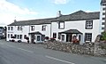
 Queens Head - geograph.org.uk - 1022085.jpg 640 × 482 ; 61 kio
-
 Road junction - geograph.org.uk - 3052544.jpg 640 × 423 ; 39 kio
-
 Roadside house to the east of Tirril village - geograph.org.uk - 6120491.jpg 640 × 480 ; 245 kio
-
 Rocky outcrop near Highfield Farm - geograph.org.uk - 6120507.jpg 640 × 480 ; 299 kio
-
 Sheep grazing above the River Eamont - geograph.org.uk - 4682764.jpg 1 024 × 768 ; 171 kio
-
 Sheep pasture between Tirril and Yanwath - geograph.org.uk - 4682761.jpg 1 024 × 768 ; 144 kio
-
 Sockbridge - geograph.org.uk - 1718739.jpg 640 × 427 ; 276 kio
-
 Sockbridge Mill - geograph.org.uk - 1718730.jpg 640 × 427 ; 257 kio
-
 South Celleron Farm, Celleron - geograph.org.uk - 4692348.jpg 1 024 × 768 ; 157 kio
-
 Sunrise at Tirril Farm cottages - geograph.org.uk - 1848202.jpg 3 472 × 2 604 ; 1,86 Mio
-
 The B5320 between Tirril and Yanwath - geograph.org.uk - 4682754.jpg 1 024 × 768 ; 125 kio
-
 The B5320 in Tirril - geograph.org.uk - 6402730.jpg 2 700 × 2 015 ; 507 kio
-
 The B5320 near Tirril - geograph.org.uk - 6402726.jpg 2 700 × 2 025 ; 384 kio
-
 The B5320 passing houses near Tirril - geograph.org.uk - 6402725.jpg 2 700 × 1 997 ; 516 kio
-
 The B5320 passing new houses at Broad Ing - geograph.org.uk - 6402728.jpg 2 700 × 2 025 ; 375 kio
-
 The road south to Askham and Haweswater - geograph.org.uk - 4682742.jpg 1 024 × 768 ; 141 kio
-
 Thorpe Field, Sockbridge - geograph.org.uk - 1718722.jpg 640 × 427 ; 265 kio
-
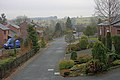
 Tirril main street - geograph.org.uk - 3052539.jpg 640 × 468 ; 48 kio
-
 Tirril Reading Room and Library, 1914 - geograph.org.uk - 4683771.jpg 1 024 × 768 ; 103 kio
-
 Tirril Village Green - geograph.org.uk - 6120487.jpg 640 × 480 ; 319 kio
-
 Trees along the B5320 - geograph.org.uk - 4682766.jpg 1 024 × 768 ; 136 kio
-
 Triangular village green, Tirril - geograph.org.uk - 4683766.jpg 1 024 × 768 ; 116 kio
-
 Two aged inhabitants - geograph.org.uk - 6120485.jpg 640 × 480 ; 366 kio


_-_geograph.org.uk_-_4683774.jpg)

_-_geograph.org.uk_-_4692371.jpg)
_-_geograph.org.uk_-_4692375.jpg)
_-_geograph.org.uk_-_4692379.jpg)


